Assisting A Location-Determining System Using Location Determined From A Communication System

a technology of communication system and location determination, applied in the direction of beacon system, measurement device, instruments, etc., can solve the problems of inertial navigation system generally, the amount of time the gps receiver requires, and the inability to find all available satellites

Inactive Publication Date: 2007-11-01
TEXAS INSTR INC
View PDF3 Cites 99 Cited by
  • Summary
  • Abstract
  • Description
  • Claims
  • Application Information

AI Technical Summary

Problems solved by technology

One problem with GPS arises if less than three satellites can be found by the receiver.
Such a situation may occur, for example, if the GPS receiver's view of the sky is obstructed (e.g. in or near a tall building).
If a signal from a satellite is lost, the receiver is forced to search for a new satellite.
Another problem with GPS relates to the amount of time the GPS receiver requires to scan the sky to locate all available satellites (a “cold start”).
GPS signals from satellites are nearly line-of-sight and inherently weak, and therefore finding all available satellites may take a substantial amount of time.
Inertial navigation systems generally suffer from “navigation drift” in which small errors in measurement aggregate into progressively larger errors in calculations of relative velocity and position.

Method used


Image

  • Assisting A Location-Determining System Using Location Determined From A Communication System
  • Assisting A Location-Determining System Using Location Determined From A Communication System

Examples


Embodiment Construction

[0017] The following discussion is directed to various embodiments of the invention. Although one or more of these embodiments may be preferred, the embodiments disclosed should not be interpreted, or otherwise used, as limiting the scope of the disclosure, including the claims, unless otherwise specified. In addition, one skilled in the art will understand that the following description has broad application, and the discussion of any embodiment is meant only to be exemplary of that embodiment, and not intended to intimate that the scope of the disclosure, including the claims, is limited to that embodiment.

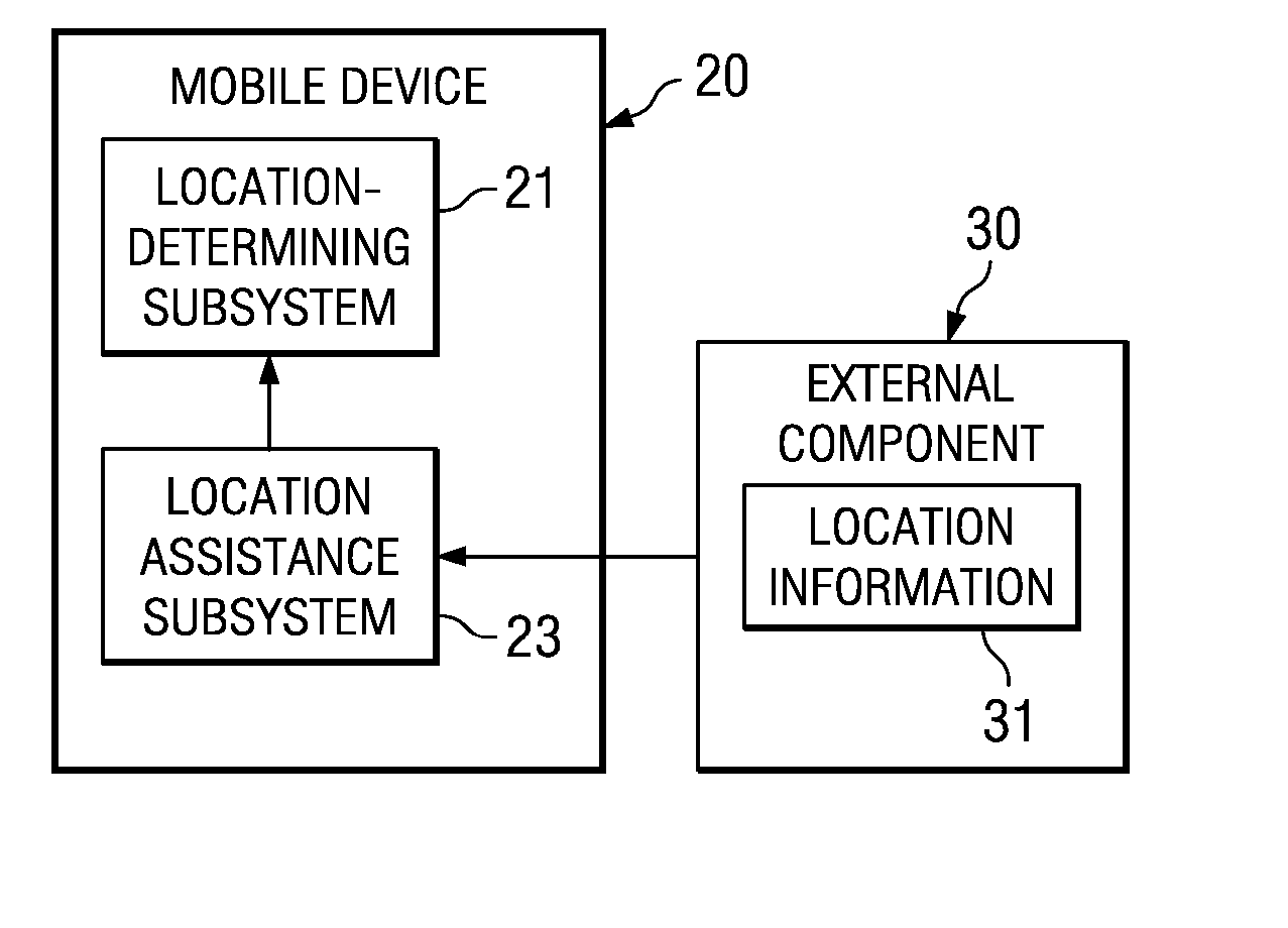
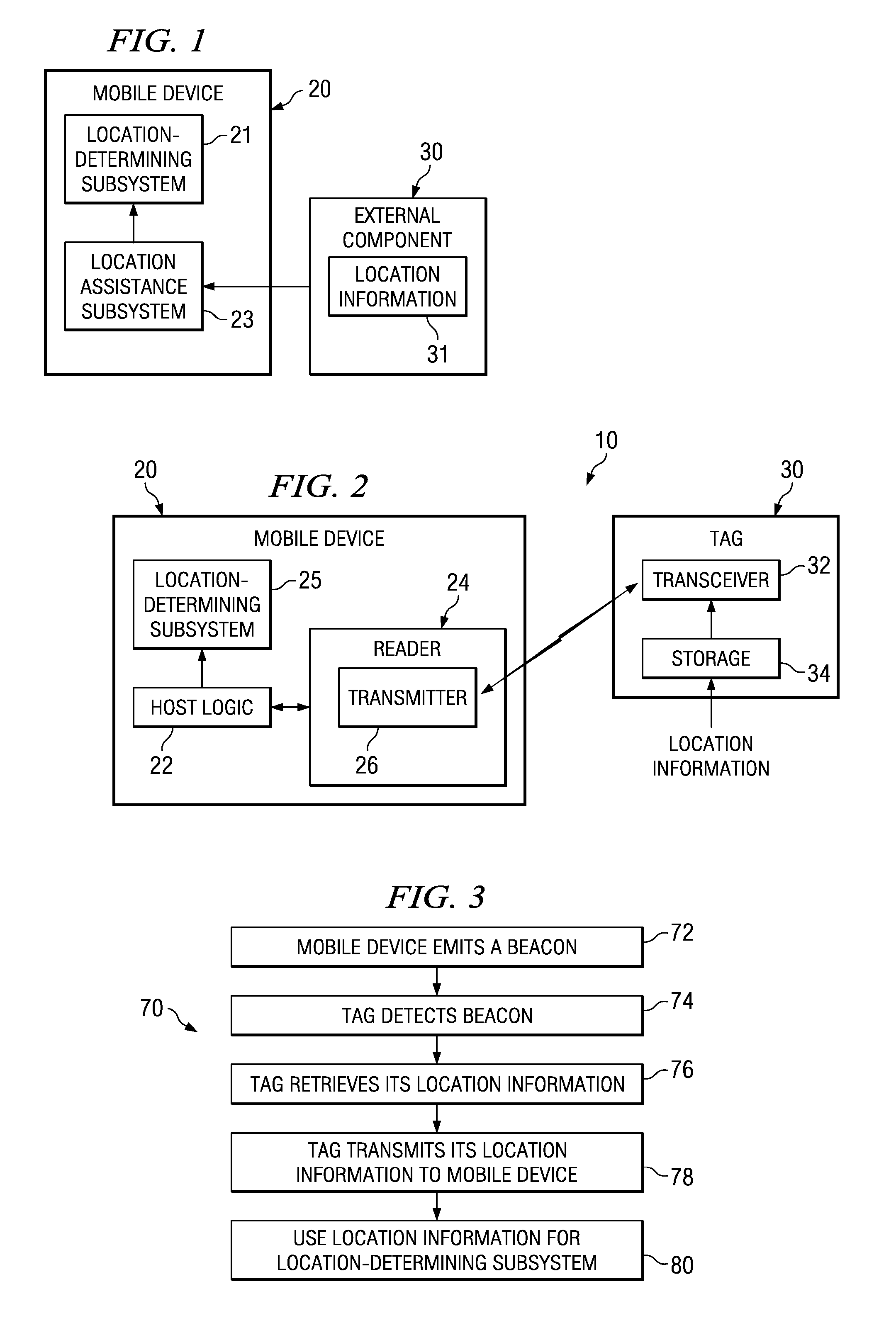
[0018] The disclosed embodiments are directed to the use of a relatively short-range (e.g., 200 feet or less) communication infrastructure, such as radio frequency identification (RFID), to estimate or infer an approximate or exact location of a mobile device and then to use that location as an input to another location-determining system. In some embodiments, such other locati...


PUM


Abstract

A mobile device comprises a location-determining subsystem and a location assistance subsystem operatively coupled to the location-determining subsystem. The second location assistance subsystem wirelessly communicates with a second transceiver that is external to said mobile device to receive location information of the second transceiver. The location information is used by the first location-determining subsystem.

Description

CROSS-REFERENCE TO RELATED APPLICATIONS [0001] This application relates to the following commonly assigned co-pending application entitled: “Location Determination With A Wireless System,” Ser. No. ______, filed ______, Attorney Docket No. TI-60799 (1962-30200); of which is incorporated by reference herein.BACKGROUND [0002] 1. Technical Field [0003] The present disclosure relates generally to assisting a location-determining system with location assistance determined from a communication system. More particularly, the present disclosure relates to using a short-range communication system, such as radio frequency identification (RFID), to, for example, streamline a satellite search for a global positioning system (GPS) receiver or to synchronize an inertial navigation system. [0004] 2. Background Information [0005] Various types of location-determining systems exist. A global positioning system (GPS), for example, uses a network of satellites in earth orbit that transmits signals at ...

Claims


Application Information

Patent Timeline
Patent Type & Authority Applications(United States)
IPC IPC(8): H04Q7/20
CPCG01S1/68G01S19/05G01S1/70G01S1/7034
Inventor PEDIGO, MADISONPANASIK, CARL
Owner TEXAS INSTR INC
Why Eureka
Try Eureka