Method of generating improved map data for use in navigation devices

a technology for navigation devices and map data, applied in traffic control systems, navigation instruments, instruments, etc., can solve problems such as the fact that the data for some geographic areas may be a year or more out of date, and that considerable effort must be expended in working out what the error really means

Active Publication Date: 2008-03-13
TOMTOM GLOBAL CONTENT
View PDF42 Cites 81 Cited by
  • Summary
  • Abstract
  • Description
  • Claims
  • Application Information

AI Technical Summary

Problems solved by technology

Despite the huge resources that go into updating and verifying these maps, the data for some geographic areas may be a year or more out of date.
These error reports are generally just in a free text format, so that considerable effort has to be expended in working out what the error really means and what exact location they relate to.

Method used


Image

  • Method of generating improved map data for use in navigation devices
  • Method of generating improved map data for use in navigation devices
  • Method of generating improved map data for use in navigation devices

Examples


Embodiment Construction

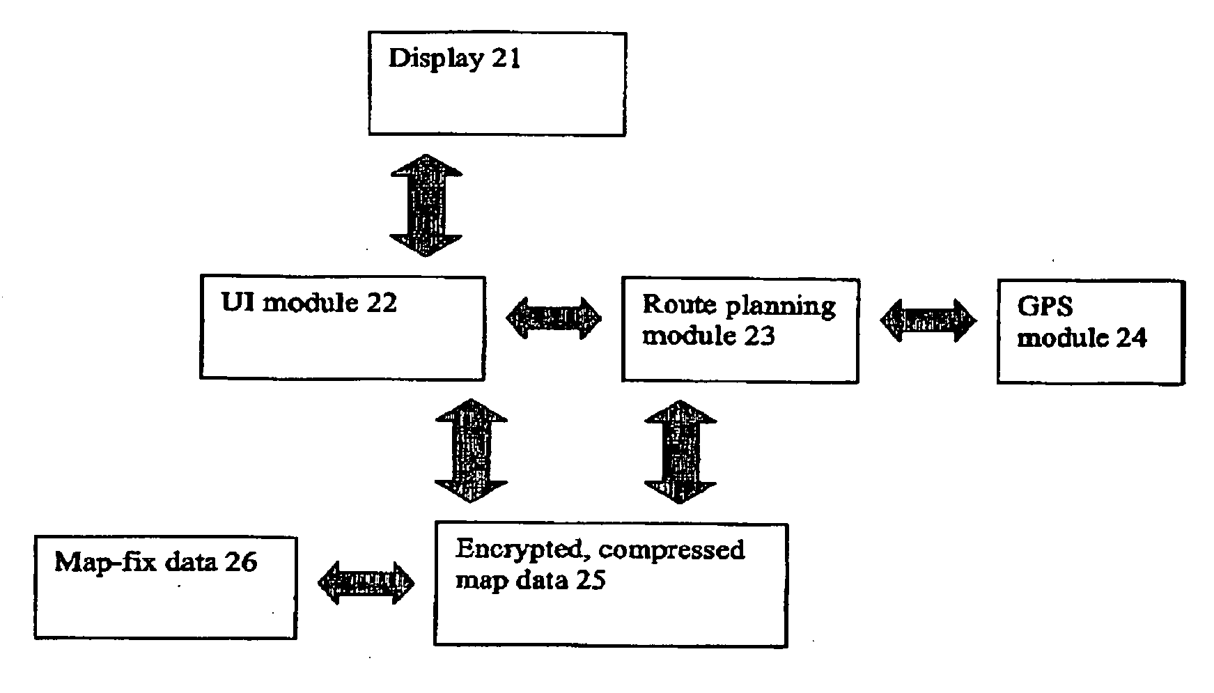
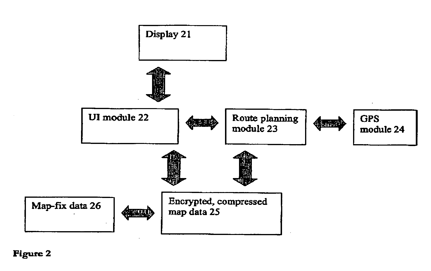
[0036] The present invention will be described with reference to an implementation called Map Share™. Map Share will allow users to fix and also to share and report map errors using GO personal navigation devices from TomTom International B.V. The user enters the correction (or map fix) into the navigation device. The map fix is then applied locally in the device to supplement the map data used by the device in routing and displaying roads, POIs etc. The map fix is immediately available. The map fix can be reported to a TomTom server by the device in a number of ways: the device may have an integral communications capability (e.g. wireless cellular system that can send data to the server), may be able to send data over a short range wireless link to a mobile telephone which in turn sends the data to the server, may be able to dock with an internet connected PC that can communicate with the server, or may itself be that internet connected PC. The server can then aggregate all correct...


PUM


Abstract

An end-user can input a correction to a map error, directly on the device. The device is then able to use the correction without external processing of the correction. Hence, it is no longer necessary for an end-user to simply report errors to the map vendor over a web link then wait for that map vendor to verify the error, update its maps and finally supply the end-user with updates—a cycle that can take months and sometimes years to complete. Instead, the navigation device can use the correction immediately. End-users can also share corrections with other end-users and also with a shared remote server that aggregates, validates and distributes corrections.

Description

FIELD OF THE INVENTION [0001] This invention relates to a method of generating improved map data for use in navigation devices. Navigation devices include GPS based electronic personal navigation devices. DESCRIPTION OF THE PRIOR ART [0002] Map data for electronic navigation devices, such as GPS based personal navigation devices like the GO™ from TomTom International BV, comes from specialist map vendors such as Tele Atlas NV. This map data is specially designed to be used by route guidance algorithms, typically using location data from the GPS system. For example, roads can be described as lines—i.e. vectors (e.g. start point, end point, direction for a road, with an entire road being made up of many hundreds of such sections, each uniquely defined by start point / end point direction parameters). A map is then a set of such road vectors, data associated with each vector (speed limit; travel direction etc.) plus points of interest (POIs), plus road names, plus other geographic featur...

Claims


Application Information

Patent Timeline
Patent Type & Authority Applications(United States)
IPC IPC(8): G01C21/32
CPCG06Q50/01G01C21/32G01C21/3856G01C21/26G01C21/36G01C21/3859G01C21/3837G01C21/3885G01C21/367G01C21/3415
Inventor GEELEN, PIETERJONES, RORY
Owner TOMTOM GLOBAL CONTENT
Why Eureka
Try Eureka