Computational Solution Of A Building Of Three Dimensional Virtual Models From Aerial Photographs

a three-dimensional virtual model and building technology, applied in the field of computation of the building of three-dimensional virtual models from aerial photographs, can solve the problems of difficult scaling of oblique photographs, insufficient topographical measurements or measurements of orthogonal photographs, and insufficient topographical measurements or measurements

Inactive Publication Date: 2008-11-13
OFEK AERIAL PHOTOGRAPHY INT
View PDF14 Cites 46 Cited by
  • Summary
  • Abstract
  • Description
  • Claims
  • Application Information

AI Technical Summary

Problems solved by technology

However, orthogonal photographs are not sufficient for topographical measurements or measurements of heights since sufficient elevation information is not available.
The challenge of photogrammetry arises from the fact that oblique photographs are not easily scaled.
Measurement capability in prior art photogrammetric solutions for oblique aerial photography is limited.
However, for other angles, prior art methods introduce errors.

Method used


Image

  • Computational Solution Of A Building  Of Three Dimensional Virtual Models From Aerial Photographs
  • Computational Solution Of A Building  Of Three Dimensional Virtual Models From Aerial Photographs
  • Computational Solution Of A Building  Of Three Dimensional Virtual Models From Aerial Photographs

Examples


Embodiment Construction

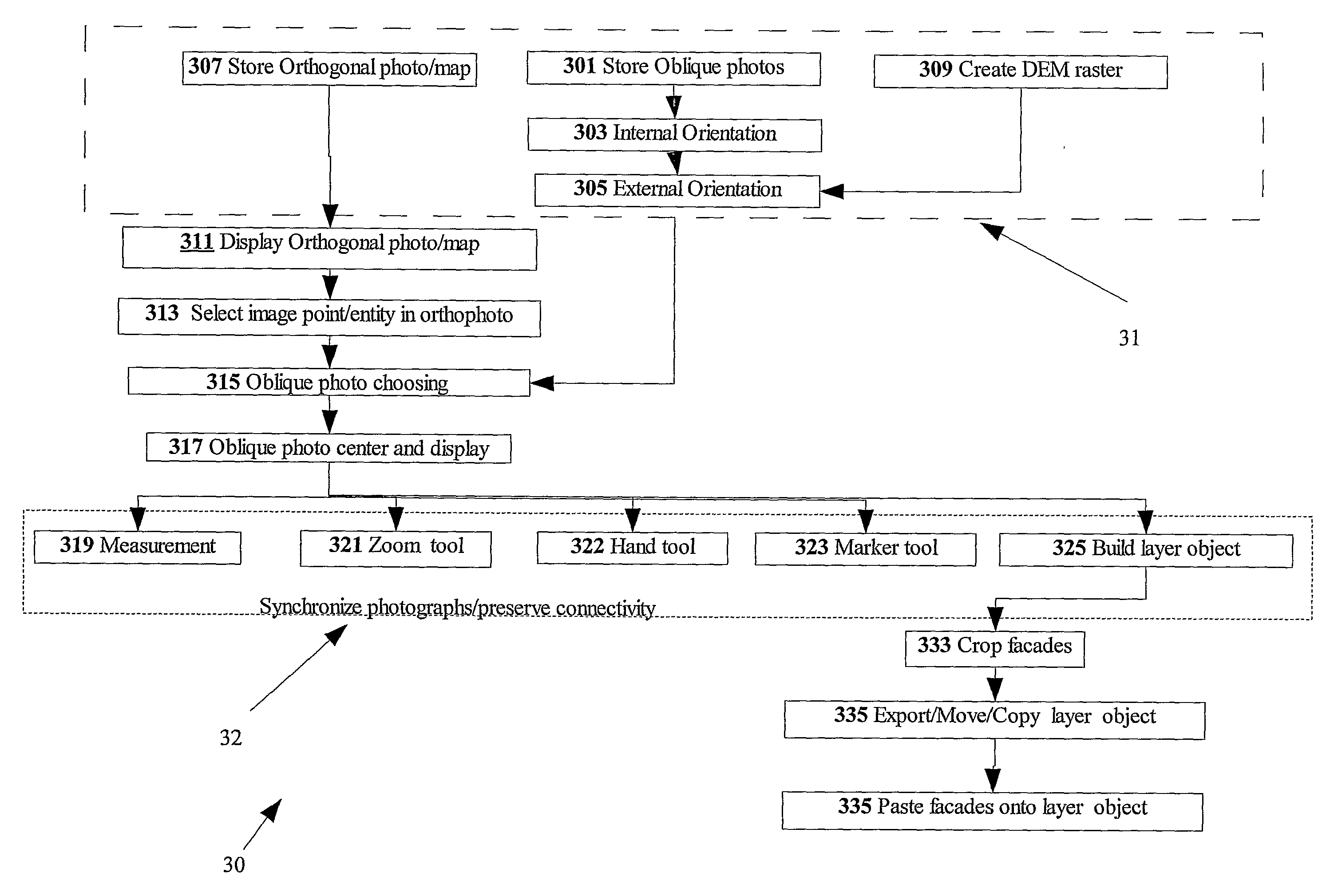
[0041]The present invention is of a system and method for providing measurements and three dimensional models based on two dimensional oblique photographs. Specifically, the system and method includes a photogrammetric computational solution combined preferably with a raster digital elevation model. The use of a raster digital elevation model as opposed to a TIN model, for instance, allows retrieving of elevation values rapidly without undue computational overhead making it possible to rapidly reference world coordinates from one oblique photograph to another of the same region. Once different views of the same region are registered together on the same display, the operator may build three dimensional virtual models of the entities visible in the oblique images.

[0042]It should be noted, that although the discussion herein relates to typically to photography of resolution of about 1 meter and digital terrain models of resolution of tens of meters, the present invention may, by non-l...


PUM


Abstract

A method for processing in a computer a plurality of digital images stored in the computer. The digital images are from respective photographs (301) of a geographic region. The photographs were taken from different directions. The method includes displaying the images (311) and upon selecting an image point in an oblique image, synchronizing a corresponding image point in the digital images so that the selected image point in the first image and the corresponding synchronized image point in other images have substantially identical world coordinates. The method is useful for performing a geographic measurement (319) on an oblique by selecting an image ground point below a first image point; calculating world coordinates in a vertical line segment which extends vertically from the image ground, and upon selecting the first image point on the vertical line segment, calculating world coordinates at the first image point based on the world coordinate in the vertical line segment.

Description

FIELD AND BACKGROUND OF THE INVENTION[0001]The present invention relates to using photogrammetric techniques for providing measurements on two dimensional oblique photographs and three dimensional models based on two dimensional oblique photographs.[0002]Conventionally, mapping of land is achieved with the use of orthogonal photography, with the camera pointing orthogonally downward towards the ground. Orthogonal photographs are easily scaled to provide horizontal distance measurements. However, orthogonal photographs are not sufficient for topographical measurements or measurements of heights since sufficient elevation information is not available. Additional methods are used for attaining elevation information such as radar, or surveying in combination with orthogonal photography. Height information is typically stored in a computer as a digital terrain model. The combination of a elevation measurements with orthogonal aerial photography is conventionally used to build a topograph...

Claims


Application Information

Patent Timeline
Patent Type & Authority Applications(United States)
IPC IPC(8): G06K9/00G06T17/05
CPCG01C11/06G06T17/00G06T2210/04G06T2207/30244G06T2207/10032G06T2207/30184G06T7/0018G06T7/80
Inventor FRIEDLANDER, ILANSHOHAM, HAIM
Owner OFEK AERIAL PHOTOGRAPHY INT
Why Eureka
Try Eureka