Data mining in a digital map database to identify insufficient superelevation along roads and enabling precautionary actions in a vehicle

a technology of digital map database and data mining, which is applied in the direction of process and machine control, navigation instruments, instruments, etc., can solve the problems of difficult to obtain consistent information about traffic accidents on roads in a large geographic region such as the entire united states or europe, and achieve the effect of increasing control authority and sensitivity

Active Publication Date: 2009-12-03
HERE GLOBAL BV
View PDF99 Cites 57 Cited by
  • Summary
  • Abstract
  • Description
  • Claims
  • Application Information

AI Technical Summary

Benefits of technology

[0008]According to further aspects, a precautionary action system installed in a vehicle uses this database, or a database derived therefrom, in combination with a positioning system, to determine when the vehicle is at a location that corresponds to the location where a precautionary action should be taken. When the vehicle is at such a location, the precautionary action is taken, such as providing a warning to the vehicle operator, as the vehicle is approaching a curve that is banked outward. Alternatively, the precautionary action may consist of an actual modification of the operation or control of th

Problems solved by technology

Accordingly, it is difficult to obtain consistent information about traffic accidents on roads in a large geographic region, such as the entire United States or Europe.
Mor

Method used


Image

  • Data mining in a digital map database to identify insufficient superelevation along roads and enabling  precautionary actions in a vehicle
  • Data mining in a digital map database to identify insufficient superelevation along roads and enabling  precautionary actions in a vehicle
  • Data mining in a digital map database to identify insufficient superelevation along roads and enabling  precautionary actions in a vehicle

Examples


Embodiment Construction

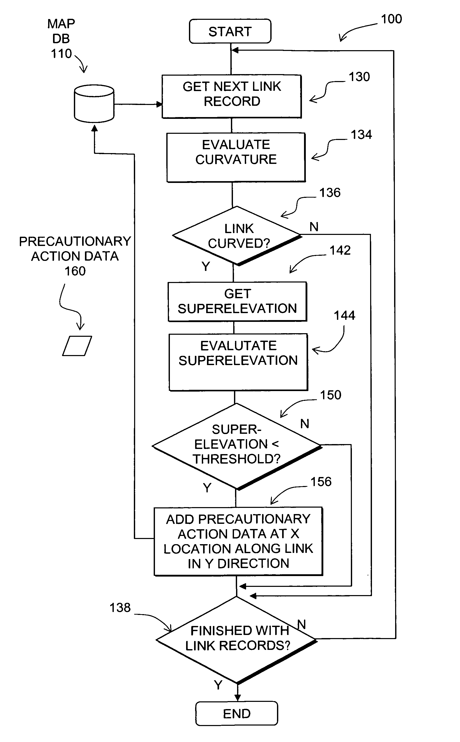
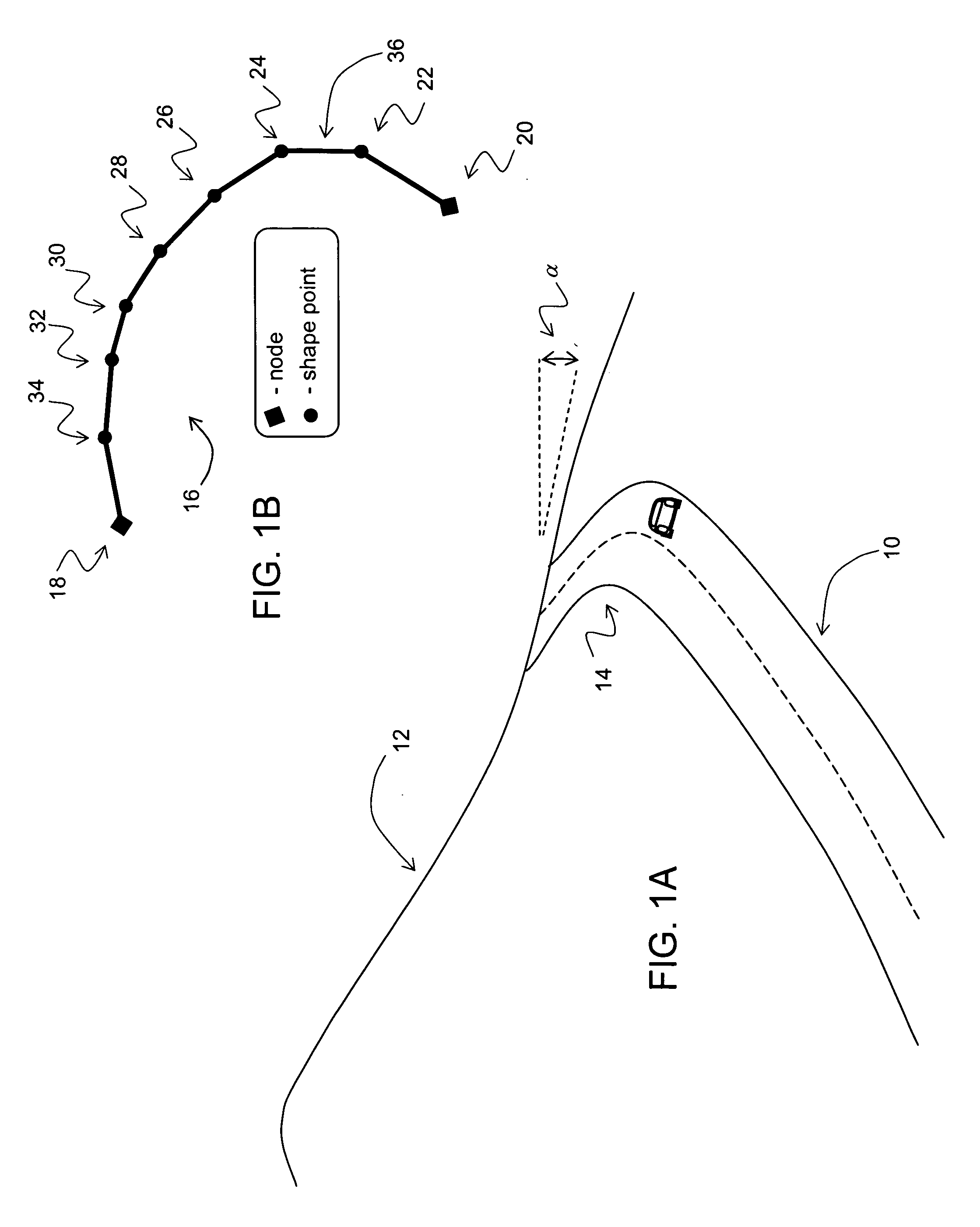
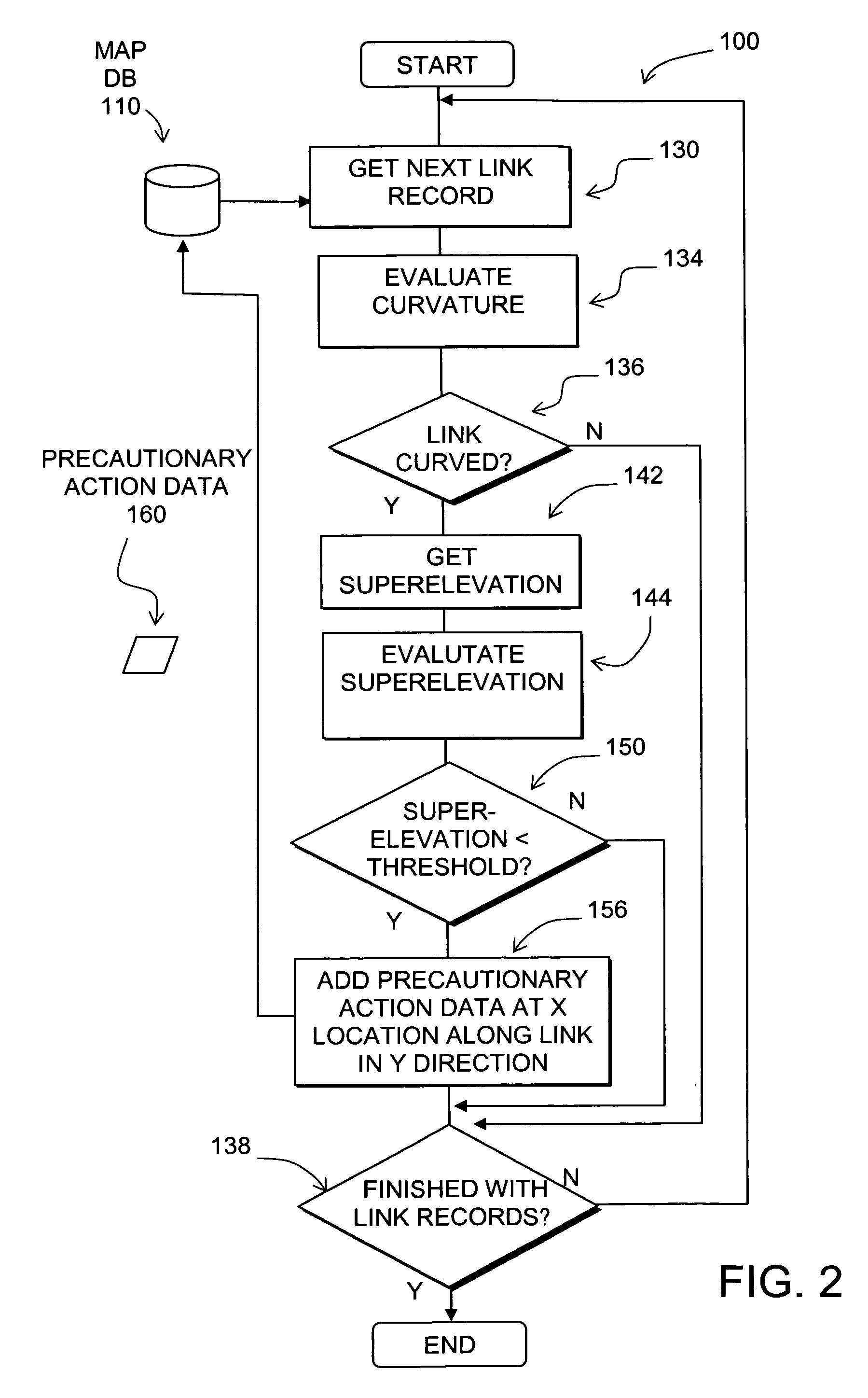
[0014]FIG. 1A depicts a road segment 10. The road segment 10 is located along a hill 12. The road segment 10 is curved along a portion 14 thereof.

[0015]Superelevation refers to a property of the road. Specifically, the superelevation of a road refers to the transverse inclination of the road surface in a curved portion of the road. Superelevation is also referred to as banking. A positive superelevation refers to a transverse inclination in which the outside edge of the road (i.e., the side farthest from the center of the curve radius) is at a higher elevation than the inside edge. A negative superelevation refers to a transverse inclination in which the outside edge of the road is at a lower elevation that the inside edge. A neutral superelevation refers to a road surface in a curve in which the outside and inside edges are at the same elevation. Roads are often constructed with a positive superelevation in curves to counter centrifugal forces that might cause slippage. A road with...


PUM


Abstract

Disclosed is a feature for a vehicle that enables taking precautionary actions in response to conditions on the road network around or ahead of the vehicle, in particular, a curved portion of a road with insufficient superelevation. A database that represents the road network is used to determine locations where curved sections of roads have insufficient superelevation (banking), i.e., where the superelevation is below a threshold. Then, precautionary action data is added to the database to indicate a location at which a precautionary action is to be taken about the location of insufficient superelevation. A precautionary action system installed in a vehicle uses this database, or a database derived therefrom, in combination with a positioning system to determine when the vehicle is at a location that corresponds to the location of a precautionary action. When the vehicle is at such a location, a precautionary action is taken by a vehicle system as the vehicle is approaching a location of insufficient superelevation.

Description

REFERENCE TO RELATED APPLICATION[0001]The present patent application is related to the copending patent application Ser. No. ______, filed on the same date, entitled “DATA MINING TO IDENTIFY LOCATIONS OF POTENTIALLY HAZARDOUS CONDITIONS FOR VEHICLE OPERATION AND USE THEREOF,” Attorney Docket No. N0260US, the entire disclosure of which is incorporated by reference herein.BACKGROUND OF THE INVENTION[0002]The present invention relates to a method and system that enables taking a precautionary action in a vehicle, such as providing a warning to a vehicle driver about a potentially difficult or hazardous driving condition on the road network.[0003]Advanced driver assistance systems (“ADAS”), including active safety and fuel economy systems, have been developed to improve the comfort, efficiency, safety, and overall satisfaction of driving. Examples of these advanced driver assistance systems include adaptive headlight aiming, adaptive cruise control, lane departure warning and control, c...

Claims


Application Information

Patent Timeline
IPC IPC(8): G01C21/00G06F19/00G06F17/30G06F7/06
CPCB60W10/06B60W10/184B60W30/18009G06F17/30241B60W2550/402G01C21/26B60W2550/14B60W30/18145B60W2552/00B60W2556/50G06F16/29
Inventor DENARO, ROBERT
Owner HERE GLOBAL BV
Why Eureka
Try Eureka