Data mining in a digital map database to identify intersections located at hill bottoms and enabling precautionary actions in a vehicle

a technology of digital map database and intersection, which is applied in the direction of pedestrian/occupant safety arrangement, navigation instruments, instruments, etc., can solve the problems of difficult to obtain consistent information about traffic accidents on roads in a large geographic region, such as the entire united states or europe, and achieve the effect of increasing control authority and sensitivity

Active Publication Date: 2009-12-03
HERE GLOBAL BV
View PDF31 Cites 56 Cited by
  • Summary
  • Abstract
  • Description
  • Claims
  • Application Information

AI Technical Summary

Benefits of technology

[0008]According to further aspects, a precautionary action system installed in a vehicle uses this database, or a database derived therefrom, in combination with a positioning system, to determine when the vehicle is at a location that corresponds to the location where a precautionary action should be taken. When the vehicle is at such a location, the precautionary action is taken, such as providing a warning to the vehicle operator, as the vehicle is approaching an intersection located at the bottom of a hill. Alternatively, the precautionary action may consist of an actual modification of the operation or cont

Problems solved by technology

Accordingly, it is difficult to obtain consistent information about traffic accidents on roads in a large geographic region, such as the entire United States or Europe.
Mor

Method used


Image

  • Data mining in a digital map database to identify intersections located at hill bottoms and enabling precautionary actions in a vehicle
  • Data mining in a digital map database to identify intersections located at hill bottoms and enabling precautionary actions in a vehicle
  • Data mining in a digital map database to identify intersections located at hill bottoms and enabling precautionary actions in a vehicle

Examples


Embodiment Construction

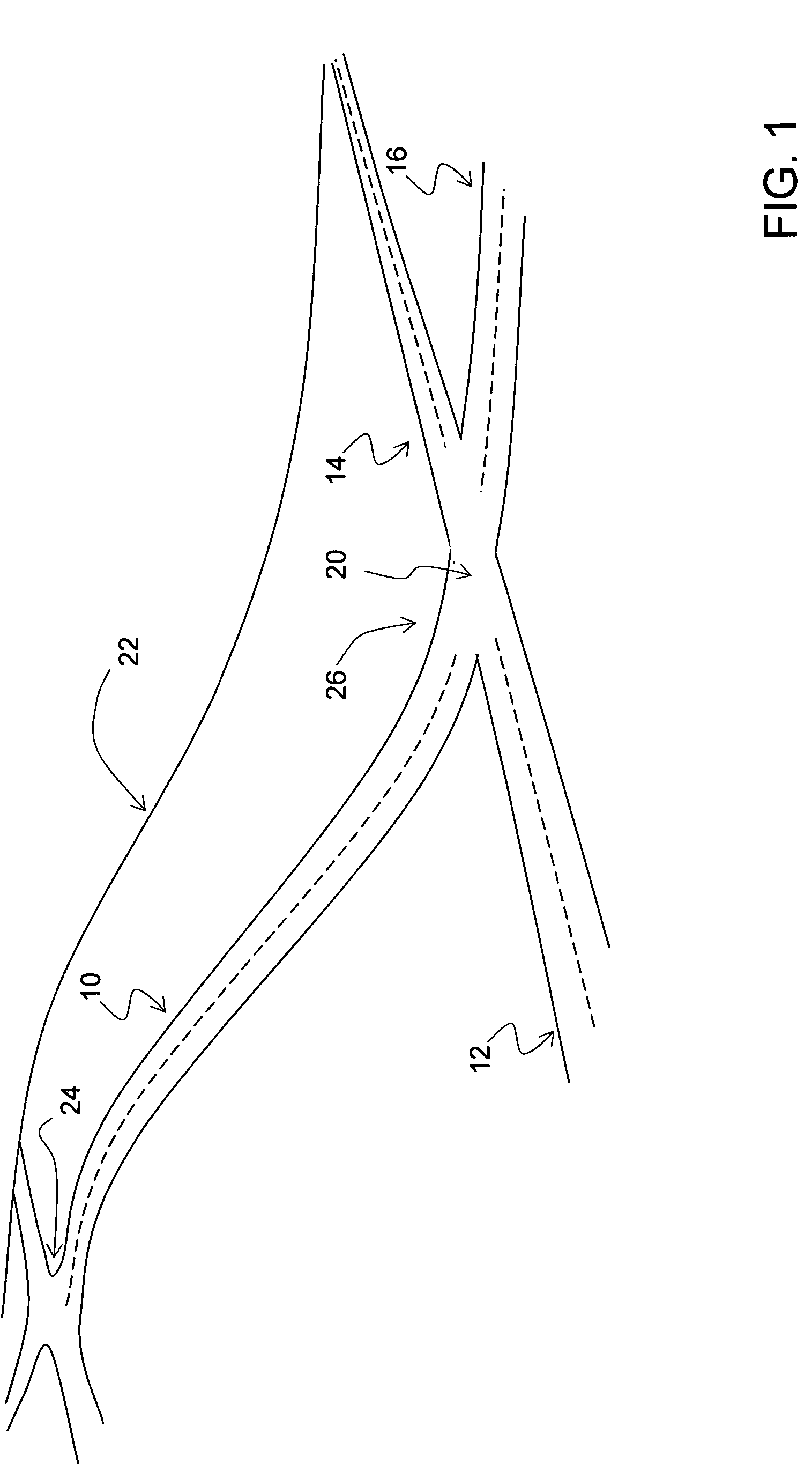
[0014]FIG. 1 depicts road segments 10, 12, 14 and 16. These road segments meet at an intersection 20. The road segment 10 is located on a hill 22, such that the altitude of one end 24 of the road segment 10 is greater than the altitude at the other end 26, which in this case is the end at the intersection 20.

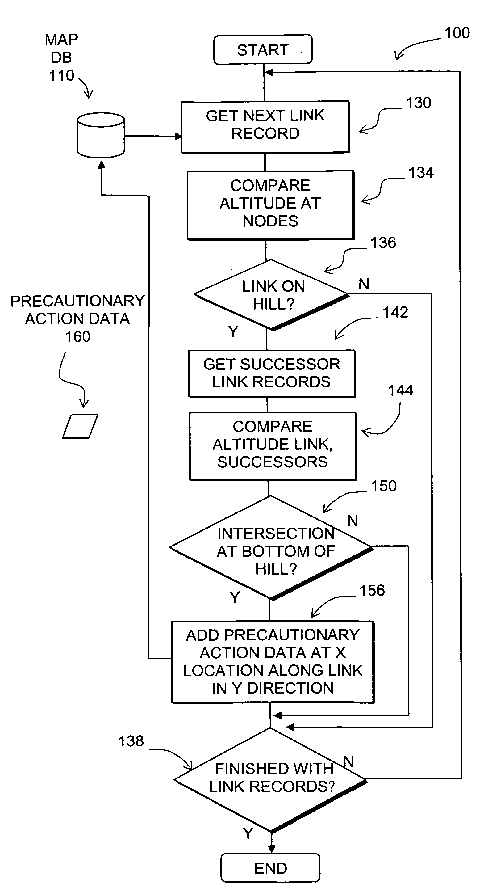
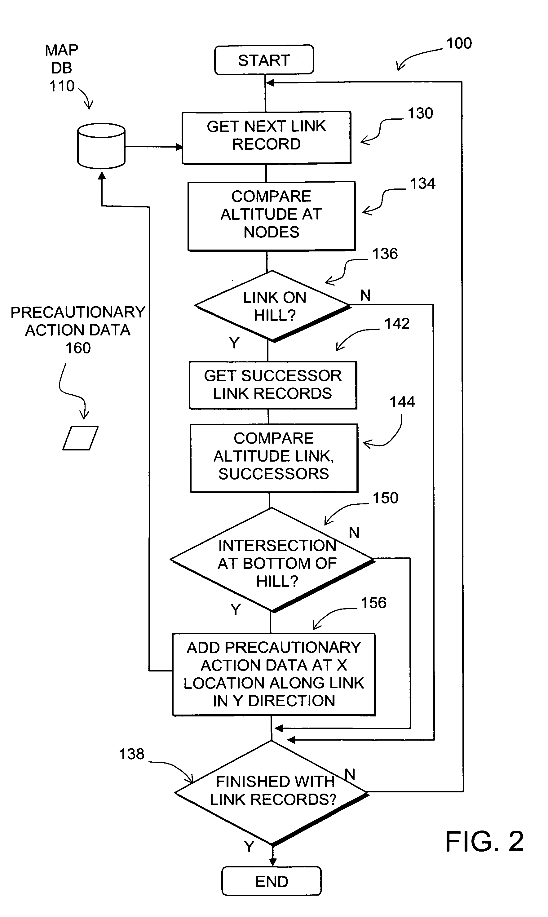
[0015]FIG. 2 is a flowchart of a process 100. The process 100 is performed by a software program or routine that is run on a suitable computing platform, such as a database server, PC or plurality of PCs coupled together for parallel computing applications.

[0016]The process 100 uses a database 110 that contains data that represents the road network in a region. The region may be a country, such as the United States, Germany, France or Korea. Alternatively, the region may include several countries or an entire continent. According to another alternative, the region may include only a portion of a country, such as a state or several states or metropolitan areas.

[0017]The process 1...


PUM


Abstract

Disclosed is a feature for a vehicle that enables taking precautionary actions in response to conditions on the road network around or ahead of the vehicle, in particular, an intersection located at the bottom of a hill. A database that represents the road network is used to determine locations where an intersection of roads is located at the bottom of a hill. Then, precautionary action data is added to the database to indicate a location at which a precautionary action is to be taken about the intersection of roads located at the bottom of a hill. A precautionary action system installed in a vehicle uses this database, or a database derived therefrom, in combination with a positioning system to determine when the vehicle is at a location that corresponds to the location of a precautionary action. When the vehicle is at such a location, a precautionary action is taken by a vehicle system as the vehicle is approaching an intersection located at the bottom of a hill.

Description

REFERENCE TO RELATED APPLICATION[0001]The present patent application is related to the copending patent application Ser. No. ______, filed on the same date, entitled “DATA MINING TO IDENTIFY LOCATIONS OF POTENTIALLY HAZARDOUS CONDITIONS FOR VEHICLE OPERATION AND USE THEREOF,” Attorney Docket No. N0260US, the entire disclosure of which is incorporated by reference herein.BACKGROUND OF THE INVENTION[0002]The present invention relates to a method and system that enables taking a precautionary action in a vehicle, such as providing a warning to a vehicle driver about a potentially difficult or hazardous driving condition on the road network.[0003]Advanced driver assistance systems (“ADAS”), including active safety and fuel economy systems, have been developed to improve the comfort, efficiency, safety, and overall satisfaction of driving. Examples of these advanced driver assistance systems include adaptive headlight aiming, adaptive cruise control, lane departure warning and control, c...

Claims


Application Information

Patent Timeline
IPC IPC(8): G06F17/30G01C21/26
CPCB60W10/06B60W10/10B60W10/184B60W40/072B60W40/076G06F17/00B60W2550/142B60W2550/402G01C21/26G01C21/3697G06F17/30241B60W2550/12G06F16/29B60W2555/20B60W2552/15B60W2556/50B60W50/0097B60W2552/00Y10S707/92B60R21/01B60R22/48B60R2021/01013B60W40/06G01C21/34
Inventor DENARO, ROBERT
Owner HERE GLOBAL BV
Why Eureka
Try Eureka