Apparatus and Method for Map Zooming

a technology applied in the field of applicator and map zooming, can solve the problems of user difficulty, user difficulty, user difficulty, etc., and achieve the effect of easy transition

Active Publication Date: 2010-08-05
RAYTHEON CO
View PDF41 Cites 69 Cited by
  • Summary
  • Abstract
  • Description
  • Claims
  • Application Information

AI Technical Summary

Benefits of technology

[0008]In general overview, the concepts, techniques, and systems described herein provide a zoom bar which adapts its world space coordinate system to reflect, control, and transform map data displayed in a geographic map. The zoom bar enables continuous map zooming of map data and smooth transitions from one map data set to another m

Problems solved by technology

A user may have difficultly operating such toggle buttons (e.g., a user may have difficultly touching toggle buttons on a touch screen to actuate the button), especially on a portable device with a relatively small display screen and, accordingly, even smaller graphical user interface components.
User difficulties may be exacerbated in certain operating environments, for example, those that require a user to wear gloves (as may be the case during inclement weather or to sa

Method used


Image

  • Apparatus and Method for Map Zooming
  • Apparatus and Method for Map Zooming
  • Apparatus and Method for Map Zooming

Examples


Embodiment Construction

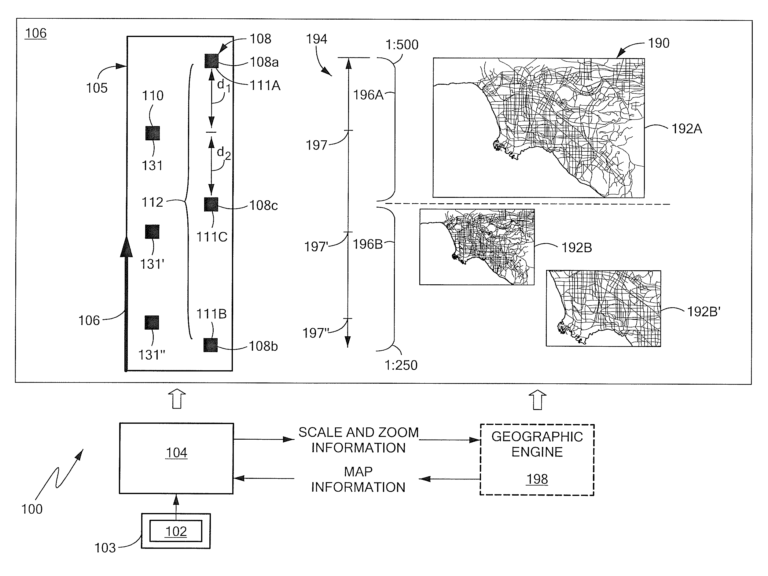
[0040]Before departing on a detailed description of embodiments of the inventive concepts, systems, and techniques described herein, it may be helpful to review certain mapping concepts related to map scale. Map scale generally refers to a ratio of a distance on a map (e.g., a distance between two cities represented on the map) to a corresponding real-world distance on the Earth's surface (i.e., the actual distance between the two cities on the Earth). For example, a map scale of 1:500 indicates that an arbitrary single unit of distance on a map is equivalent to 500 similar units of distance on the ground. If the map is defined in feet, for example, then the map scale 1:500 (which may be expressed in other ways such as 1 / 500) indicates that every map-foot represents 500 feet on the ground. Map scale may also be expressed as 1 inch equals 500 feet (i.e. different distance units) in which case 1 inch on the map corresponds to 500 feet of actual distance). Thus, if two locations on the...


PUM


Abstract

An apparatus for map zooming includes instructions stored in a memory that when executed by a processor render a zoom bar. The zoom bar includes a plurality of map scale hash marks arranged along an axis of the zoom bar and indicative of a map scale range of a geographic map. The plurality of map scale hash marks include a first map scale hash mark representative of a first map scale, a second map scale hash mark offset along the zoom bar axis from the first map scale hash mark and representative of a second map scale, and a map transformation hash mark located between the first and second map scale hash marks and representative of a transformation of the geographic map from a first map data set defined with reference to the first map scale to a second map data set defined with reference to the second map scale. The zoom bar further includes a map zoom bar indicator located relative to the first and second map scale hash marks and corresponding to a current map display scale and a zoom level of the geographic map.

Description

CROSS-REFERENCE TO RELATED APPLICATIONS[0001]This application claims priority under 35 U.S.C. §119(e) from U.S. Provisional Patent Application No. 61 / 149,772, filed Feb. 4, 2009, which application is hereby incorporated herein by reference in its entirety for all purposes.FIELD OF THE INVENTION[0002]The system and techniques described herein relate generally to map display and more particularly to an apparatus and method for map zooming.BACKGROUND[0003]As is known in the art, a map is a visual representation of a geographic. A map may include symbolic depictions highlighting relationships between elements of a space or a defined geographic region such as objects, regions within the defined geographic region, and themes. Some maps are static two-dimensional, geometrically accurate representations of a three-dimensional space, while others are dynamic or interactive, even three-dimensional. Although most commonly used to depict geographic regions, maps may also represent any space, re...

Claims


Application Information

Patent Timeline
IPC IPC(8): G06F3/048G09G5/00
CPCG06F3/0488G09G2354/00G09G2340/045
Inventor HOFF, CHRISTOPHER G.BATHRICK, III, ERWIN WARD
Owner RAYTHEON CO
Why Eureka
Try Eureka