Integrated GIS System with Interactive 3D Interface

a gis system and interactive technology, applied in the field of integrated gis systems, can solve problems such as inefficiency of the iterative process

Active Publication Date: 2011-09-15
INTERGRAH TECH CO
View PDF21 Cites 22 Cited by
  • Summary
  • Abstract
  • Description
  • Claims
  • Application Information

AI Technical Summary

Benefits of technology

[0007]Embodiments of the present invention integrate 2.5D GIS information maintained by a 2D GIS system with the 3D information and 3D rendering capabilities of the 3D rendering engine to provide an integrated GIS system having an interactive 3D interface. In essence, the system inserts GIS information into the 3D rendering in the 3D window and allows the user to manipulate the 3D graphic indicia and other information contained in the 3D window by intercepting user inputs and converting them for use by the 2D GIS system. The 2D GIS system can determine where in the 3D window the user is working and therefore can determine corresponding 2D geo-location coordinates for use in core 2D GIS functions performed through the 3D window.

Problems solved by technology

As can be imagined, such an iterative process is inefficient.

Method used


Image

  • Integrated GIS System with Interactive 3D Interface
  • Integrated GIS System with Interactive 3D Interface
  • Integrated GIS System with Interactive 3D Interface

Examples


Embodiment Construction

[0021]Definitions. As used in this description and the accompanying claims, the following terms shall have the meanings indicated, unless the context otherwise requires:

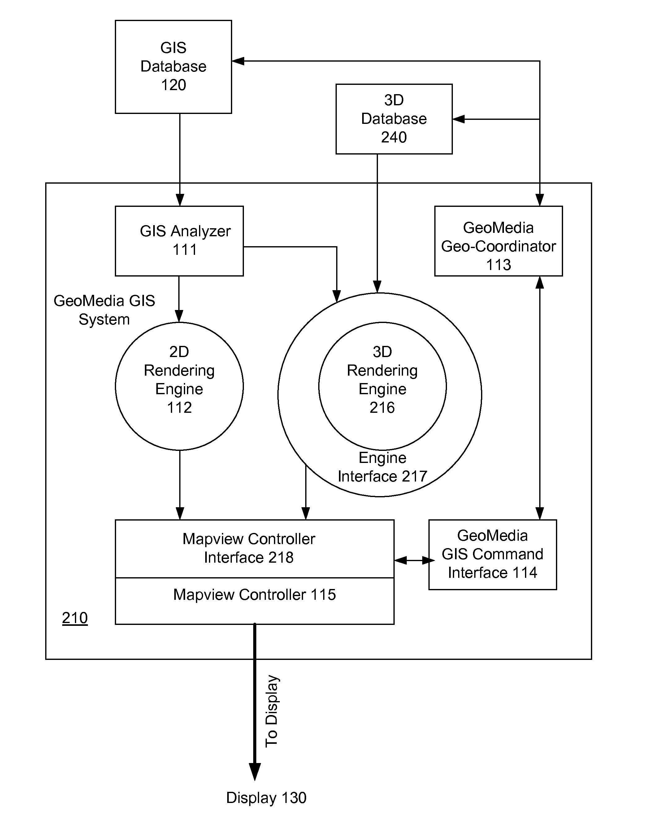
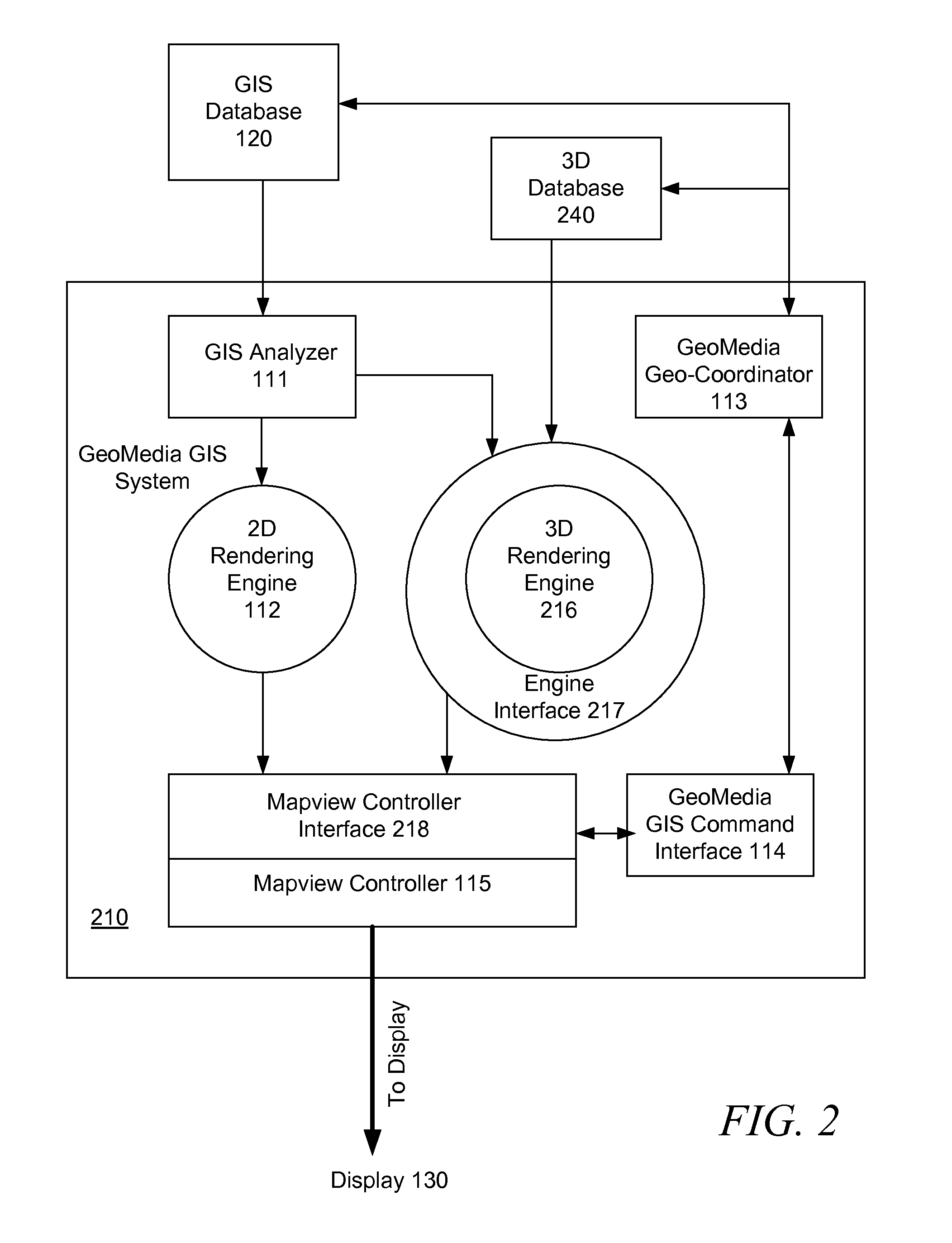
[0022]2.5D GIS data is geospatial data that is two-dimensional in nature (e.g., polyline, polygon, point, etc.) but each coordinate is represented by an X, Y, and Z value, where the Z value represents elevation / height. GIS data may include such things as location, elevation, precincts, districts, counties, roadways, building, water pressure readings, etc. Each element may have associated metadata. For example, a road might be associated with a road name, direction, starting / ending addresses, road type (e.g., dirt vs. paved), etc. 2.5D GIS data may include image data (e.g., raster data) that can be overlayed onto or draped over components of a geographical rendering.

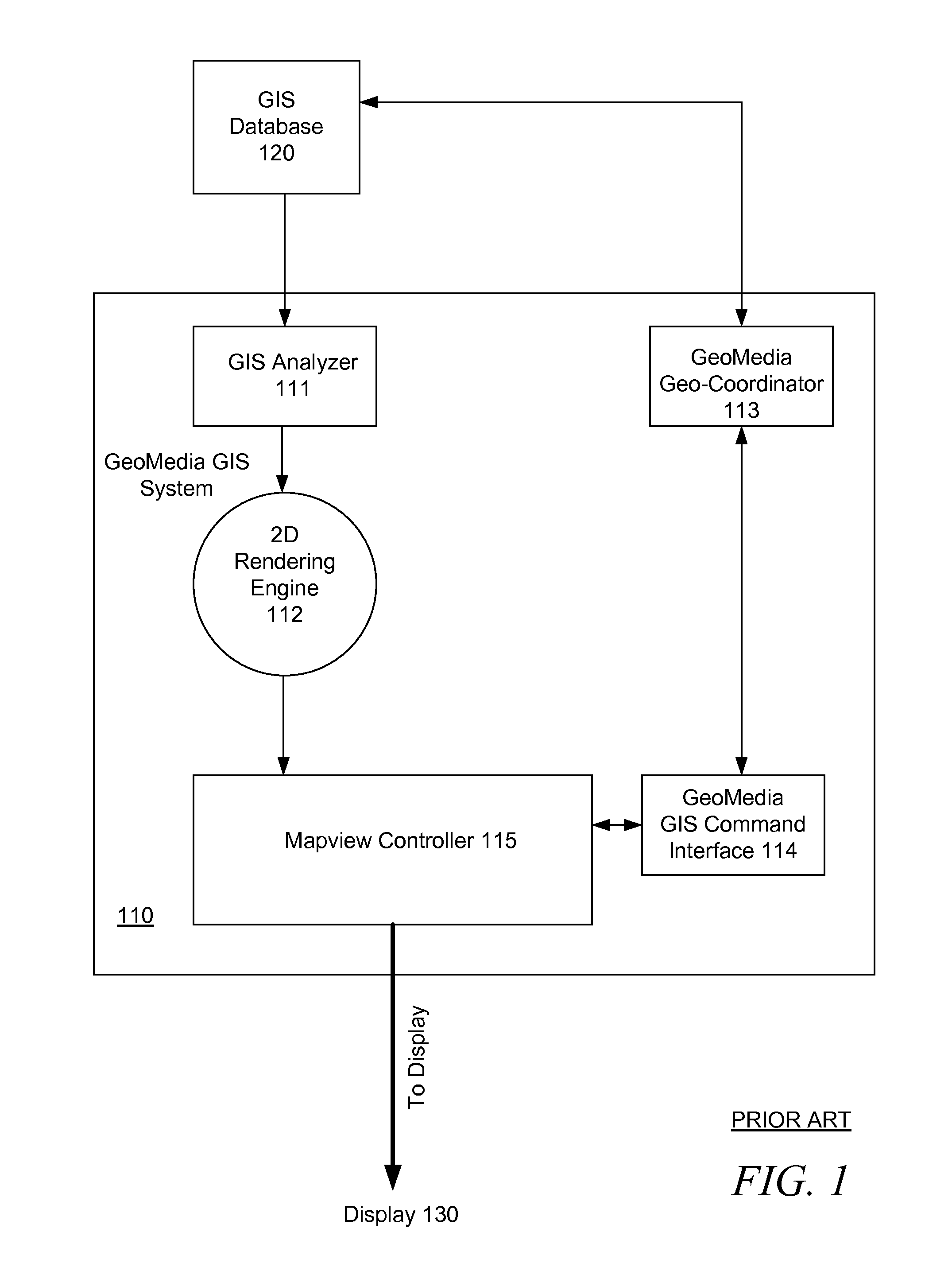
[0023]A 2D GIS system or visualization tool is a GIS system that processes 2.5D GIS data for visualization, placement, editing, and analysis using essenti...


PUM


Abstract

An integrated GIS system in which a 3D visualization system is integrated with a 2D GIS system using interfaces that map 2D components for 3D visualization and map 3D components for processing by the 2D GIS system. A 2D GIS system and a 3D visualization system are integrated through interfaces that provide for 3D visualization of 2.5D GIS data as well as interactive control of the 2D GIS system from 3D windows containing 3D renderings produced by the 3D visualization system. User selections made in a 3D window are mapped to 2D geo-location coordinates for to use by the 2D GIS system components. Changes made via the 3D window to 3D graphic indicia and/or metadata are used to modify GIS data in a GIS database, and the modified GIS data is used to update the 3D rendering to reflect the user changes.

Description

FIELD OF THE INVENTION[0001]The present invention relates generally to an integrated GIS system and more specifically to an integrated GIS system in which a 3D visualization system is integrated with a 2D GIS system using interfaces that map 2D components for 3D visualization and map 3D components for processing by the 2D GIS system.BACKGROUND OF THE INVENTION[0002]Generally speaking, a Geographic Information System (GIS) is a system that allows for the capture, storage, analysis, management, and presentation of location-based data for a variety of applications. Among other things, a GIS typically allows users to create interactive queries, analyze spatial information, edit data, and create maps. A good overview of GIS technology and products can be found in WIKIPEDIA™ at http: / / en.wikipedia.org / wiki / Geographic_information_system, the content of which is hereby incorporated herein by reference in its entirety.[0003]Many GIS products provide for two-dimensional (2D) visualization and...

Claims


Application Information

Patent Timeline
Patent Type & Authority Applications(United States)
IPC IPC(8): G06F3/048G06F17/30
CPCG06T17/05G06T15/00G06T19/00
Inventor BOERSMA, MICHAEL RODNEYSTEPHENS, JAMES RICHARDGLENN, DAVID MILTON
Owner INTERGRAH TECH CO
Why Eureka
Try Eureka