Road map feedback server for tightly coupled GPS and dead reckoning vehicle navigation

Inactive Publication Date: 2011-10-20
FURUNO ELECTRIC CO LTD
View PDF2 Cites 103 Cited by
  • Summary
  • Abstract
  • Description
  • Claims
  • Application Information

AI Technical Summary

Problems solved by technology

The typical GPS navigation receiver used in these vehicles is accurate to tens of meters in good environments but can degrade to even a hundred meters in dense urban environments.
But if GPS reception is lost, as commonly occurs in tunnels and parking garages, the user position on the map display screen will simply not update.
Drivers will not accept long start-up times or navigation failures that result simply from driving into tunnels or parking garages.
However, the inertial sensors imp

Method used


Image

  • Road map feedback server for tightly coupled GPS and dead reckoning vehicle navigation
  • Road map feedback server for tightly coupled GPS and dead reckoning vehicle navigation
  • Road map feedback server for tightly coupled GPS and dead reckoning vehicle navigation

Examples


Embodiment Construction

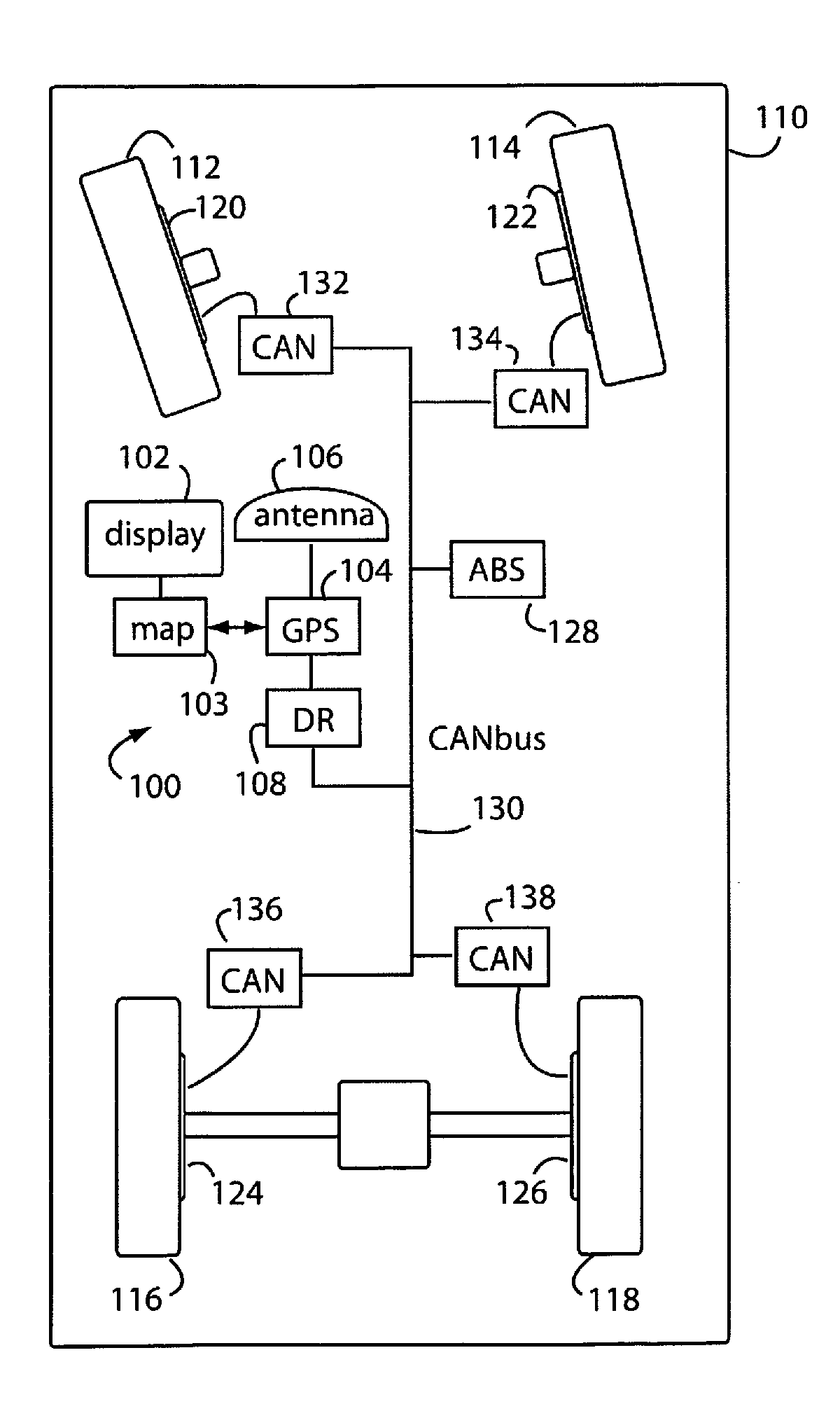
[0024]FIG. 1 represents a GPS and dead-reckoning (DR) combination embodiment of the present invention, referred to herein by the general reference numeral 100. The GPS and dead reckoning combination 100 provides navigation information on a display 102 to a user. A road map disk and player 103 display the current user position in relation to the local roads. A GPS receiver 104 tunes in and tracks microwave satellite transmissions through an antenna 106, and is tightly coupled with calibrated “delta-heading” and “delta-range” information calculated by a dead reckoning (DR) computer 108. The “delta” term signifies how the heading, or direction, of a vehicle 110 has changed over time, and how the range, or distance has changed over the same period.

[0025]Both GPS receiver 104 and road map disk and player 103 provide corrections and feedback to the DR computer 108. GPS receiver 104 provides absolute position and heading fixes, on which the DR computer 108 can add its calibrated delta-head...


PUM


Abstract

Road map feedback is used in a tightly coupled GPS and dead-reckoning system that collects wheel speed transducer data over a vehicle's CANbus network to compute vehicle range and direction. Road segment information provided by a network server provides a database of constraints that are templated on to current navigation solutions so that corrective feedback can be derived. The dead-reckoning bridges over gaps in navigation solutions that would otherwise occur when GPS signal transmission is lost in tunnels, parking garages, and other common situations. The road map fitting controls drift that would otherwise accumulate during long periods of dead reckoning only operation.

Description

BACKGROUND OF THE INVENTION[0001]1. Field of the Invention[0002]The present invention relates to vehicle navigation systems, and more particularly to road map correction feedback provided by wireless network servers for tightly coupled combinations of global position system (GPS) receivers and dead-reckoning in vehicles.[0003]2. Description of Related Art[0004]GPS navigation systems with street map displays are now widely available in most new vehicles throughout the world. New map updates are purchased and installed with DVD disks, and seem to come out every year on an annual basis. The typical GPS navigation receiver used in these vehicles is accurate to tens of meters in good environments but can degrade to even a hundred meters in dense urban environments. These vehicle navigation systems assume the vehicle is traveling on the mapped roads, and therefore use the map information to snap the vehicle position icon to the exact path of the nearest road. But if GPS reception is lost,...

Claims


Application Information

Patent Timeline
IPC IPC(8): G01C21/26G01S19/47
CPCG01C21/30G01S19/47G01S19/40
Inventor MCBURNEY, PAUL W.HIRSCH, ERIC
Owner FURUNO ELECTRIC CO LTD
Why Eureka
Try Eureka