Method and system for transmitting and/or receiving at least one location reference, enhanced by at least one focusing factor

a technology of location reference and focusing factor, applied in the direction of navigation, instruments, surveying and navigation, etc., can solve the problems of limiting the extent and currency of agreed upon location codes, affecting the decoding process, and affecting the speed of the location calculation at the end user mapping device, etc., to achieve the effect of improving the decoding process

Active Publication Date: 2011-11-24
TOMTOM GLOBAL CONTENT
View PDF19 Cites 84 Cited by
  • Summary
  • Abstract
  • Description
  • Claims
  • Application Information

AI Technical Summary

Benefits of technology

At least one embodiment of the present application is directed toward conveying location reference information in a more universally useable manner and / or conveying location reference information in a manner which improves the decoding process at the remote device.

Problems solved by technology

Further, if too much information is conveyed, the speed of the location calculation at the end user mapping device may undesirably slow down.
However, such an authority has to maintain the codes, and the vendors of each of the databases or mapping application vendors have to incorporate these codes for subsequent application in all devices utilizing mapping applications.
Such processes naturally limit the extent and currency of agreed upon location codes, which cover only a tiny fraction of map locations.
Yet there are still enough differences between data models, geometry and attributes and map data from different vendors and different versions of maps to make reliable road location referencing a non-trivial problem.
To reach an acceptable rate, some methods increase the amount of information provided regarding the location, which causes increased location encoding footprint, and requires inordinate encoding and decoding time.
Thus, as the information content or location footprint become too large, decoding becomes a problem, especially in smaller end-user mapping devices which may not have significant processing power (such as portable navigation devices, for example).
However, the method is enormously complex, encoding is computationally intensive, and a location encoding footprint is relatively large, which may cause poor performance of the decoding process on small end user mapping devices.
In such methods, the shortest path computation which takes place in both an encoder of information and a decoder of information, is driven by a cost of travel along the link, wherein the more important the road, the cheaper the cost of travel per unit of distance.
However, FRC attributes in map data are often results of a judgment call of a digital cartographer or field data collector, wherein mapmakers have no firm standard or agreements on FRCs.
Accordingly, FRCs are often a likely culprit in location dereferencing errors, noting that differences in cost induced by ambiguous FRC mapping between different maps may cause significant difference in path computation by a decoding device, such as an end user mapping device 200 for example.
Furthermore, introduction of massive amounts of probe data utilized for map data updating will subject mid-tier FRCs to a high rate of change, causing location referencing match rates to degrade even on data from different releases of the map databases from the same vendor.
While fast decoding speed is critical, a path reconstruction process on a decoding device often performs unnecessary work, exploring all potential routing nodes in a large area.

Method used


Image

  • Method and system for transmitting and/or receiving at least one location reference, enhanced by at least one focusing factor
  • Method and system for transmitting and/or receiving at least one location reference, enhanced by at least one focusing factor
  • Method and system for transmitting and/or receiving at least one location reference, enhanced by at least one focusing factor

Examples


Embodiment Construction

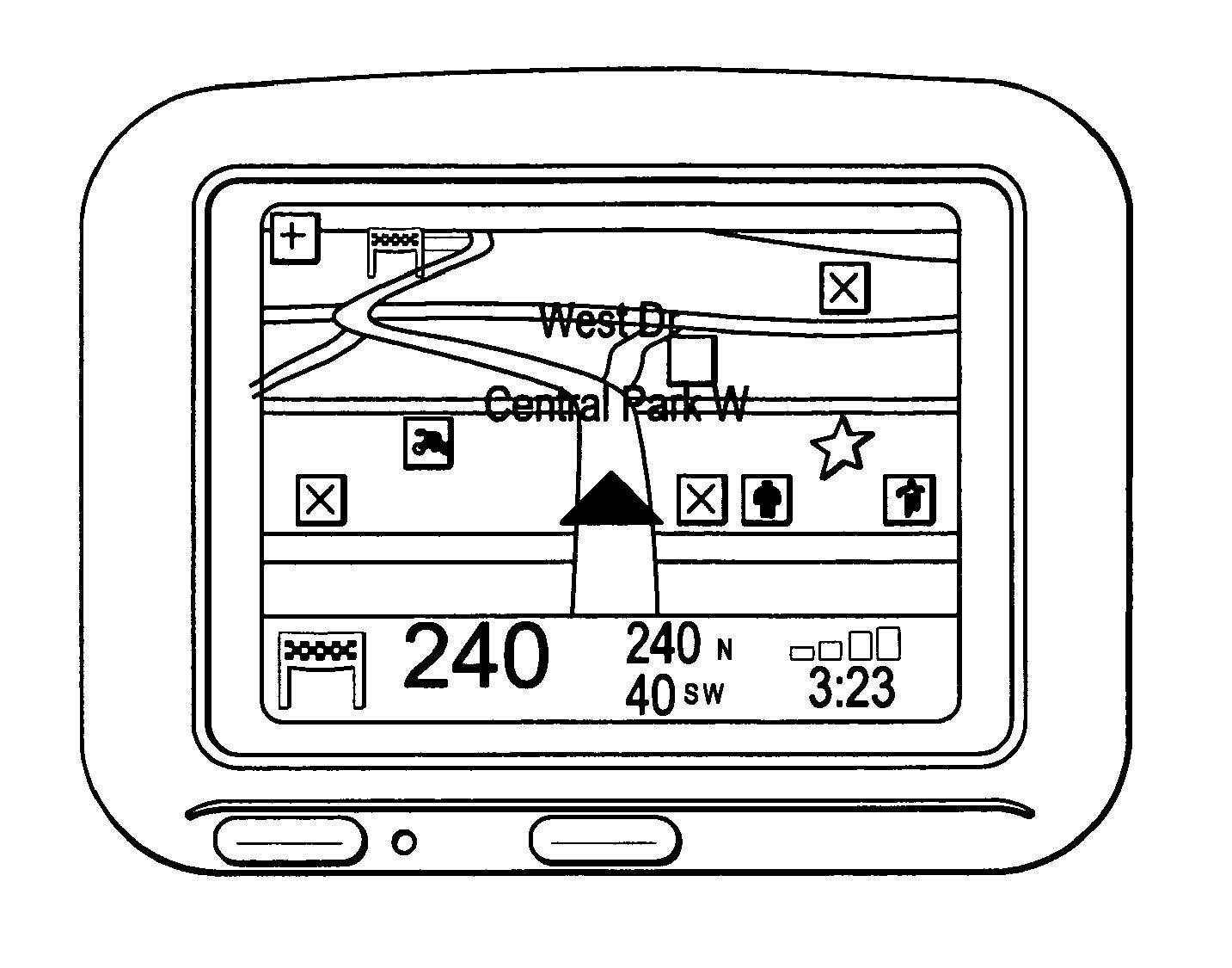
Example embodiments of the present invention will now be described with particular reference to end user mapping devices, including but not limited to a personal navigation device (PND). It should be remembered, however, that the teachings of the present invention are not limited to PNDs or even other navigation devices, but are instead universally applicable to any type of mapping devices including but not limited to processing devices that are configured to execute mapping software so as to provide route planning and / or navigation and / or other types of mapping services. These include but are not limited to hand-held devices such as personal digital assistants (“PDAs”), personal navigation devices (PNDs), and cell phones or other types of mobile devices that can perform mapping services; desktop applications, and Internet applications in which users can generate maps showing desired places, etc., collectively referenced herein as “end user mapping devices”.

Note that servers that ty...


PUM


Abstract

A method and system are disclosed. In at least one embodiment, the method includes at least one of obtaining and receiving information regarding at least one location reference at a server (302) for transmission to at least one remote device; determining at least one path of the at least one location reference corresponding to at least one pair of points within mapping information at the server (302); computing at least one focusing factor at the server (302) based upon encoded information corresponding to the determined at least one path of the at least one location reference, and enhancing the at least one location reference by the computed at least one focusing factor; and transmitting the at least one location reference enhanced by the computed at least one focusing factor from the server (302) to the at least one remote device.

Description

FIELD Embodiments of the present invention generally relate to methods and / or systems for transmitting information, for use in navigation for example, and / or method and systems for receiving and processing the transmitted information.BACKGROUND In recent years, consumers have been provided with a variety of devices and systems to enable them to locate places or destinations on a digital map. The terms “places” or “destinations” are general terms used throughout the description of embodiments of this invention. The term “places” or “destinations” includes street addresses, buildings located at street addresses such as businesses and landmarks, and facilities located at a number of street addresses such as shopping malls and business parks. The variety of devices and systems used by consumers or “users” are in the form of in-vehicle navigation systems that enable drivers to navigate over streets and roads; hand-held devices such as personal digital assistants (“PDAs”), personal naviga...

Claims


Application Information

Patent Timeline
Patent Type & Authority Applications(United States)
IPC IPC(8): G01C21/00
CPCG01C21/32G01C21/3446G01C21/3896
Inventor KUZNETSOV, TSIA
Owner TOMTOM GLOBAL CONTENT
Why Eureka
Try Eureka