Systems and methods for location positioning within radio access systems

a radio access system and location technology, applied in the field of mobile radio access systems, can solve the problems of difficult or impossible to determine in mountainous terrain or in the city around high buildings, difficult or impossible to achieve the effect of low cost, easy positioning, and good complement to or replacemen

Inactive Publication Date: 2011-12-22
TAIWAN SEMICON MFG CO LTD
View PDF7 Cites 48 Cited by
  • Summary
  • Abstract
  • Description
  • Claims
  • Application Information

AI Technical Summary

Benefits of technology

Another object of the invention is to provide methods and systems for determining the location of a mobile caller that are inexpensive and applicable over a wide area, without requiring a dedicated infrastructure.
Advantageously, the invention does not require to equip a mobile with GPS for automatic location identification, thus enabling low cost user equipment to readily locate itself. In addition, since adoption of the WiMax standard, the trend in the wireless networking is to adopt similar technologies in the next generations of wireless networks such as 3GPP LTE and UMB systems. As such, the invention can be also applied to 3GPP LTE and UMB systems.
Another advantage of the method and systems of the invention is that it allows implementation of E911 location based services within WiMax systems using WiMax equipment. The invention is a good complement to, or replacement for GPS in some environments, particularly indoor environments where supposedly 80% of WiMax and 911 services users are situated, particularly once small WiMax BT or access points and Femto BTSs will be installed.

Problems solved by technology

However, the current network based methods are not very accurate and may not work particularly well in an indoor environment.
However, the AOA, TOA and round trip delay methods are based on line of sight distance measurements (straight distance between the UE unit and the antennae), which can be difficult or impossible to determine in mountainous terrain or in the cities around high buildings and other obstacles.
Therefore, the results obtained with these methods are inaccurate.
In addition, the location of the caller is not very accurate, especially in the case of indoor calls.
However, the process of searching for and acquiring GPS signals, reading the ephemeris data for a multiplicity of satellites and computing the location of the receiver from this data is time consuming, often requiring several minutes.
In many cases, this lengthy processing time is unacceptable, particularly in emergency situations where location is being determined for a 911 dispatch centre.
In addition, in order to use GPS, the mobile device must be GPS-enabled, which is not always the case.
Equipping the mobiles with GPS units also increases the cost, which may become prohibitive for many.
Still further, a GSP receiver does not operate properly in some types of environment such as indoors or where satellite signals get blocked.
All the methods described above have not yet provided satisfactory solutions to the problem of wirelessly determining the location of callers using small, inexpensive and low power roaming devices.
Also, current methods and systems do not operate well over a wide area, without requiring a dedicated infrastructure.

Method used


Image

  • Systems and methods for location positioning within radio access systems
  • Systems and methods for location positioning within radio access systems
  • Systems and methods for location positioning within radio access systems

Examples


Embodiment Construction

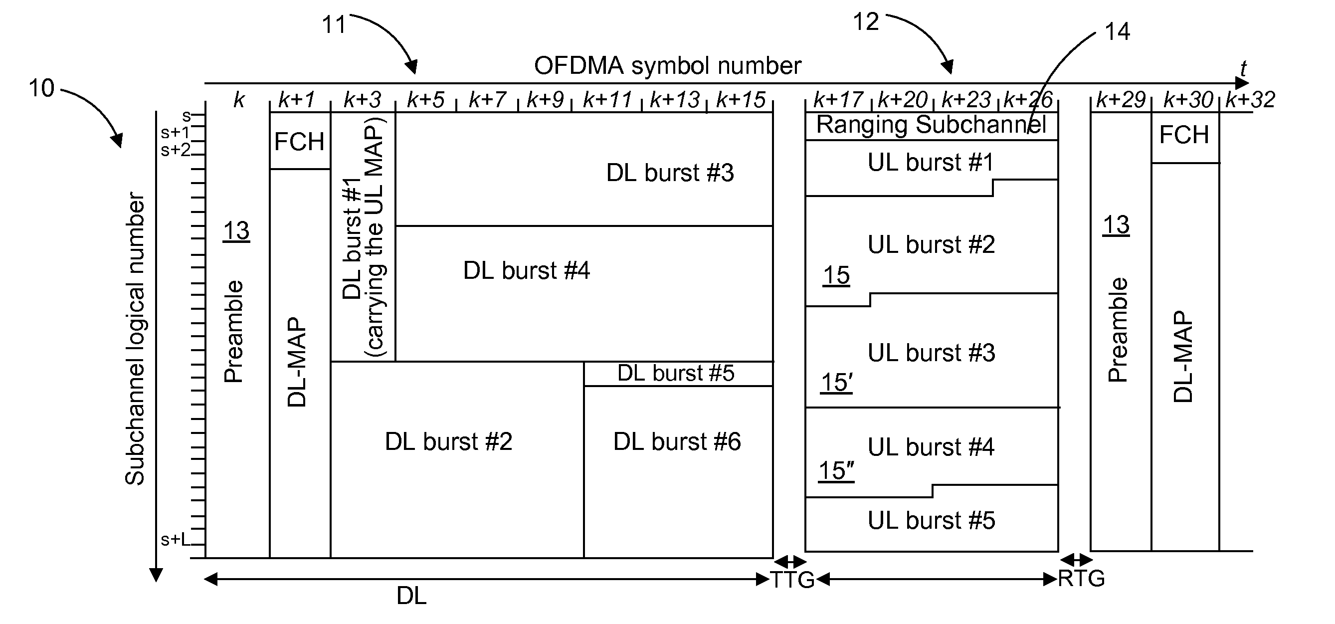
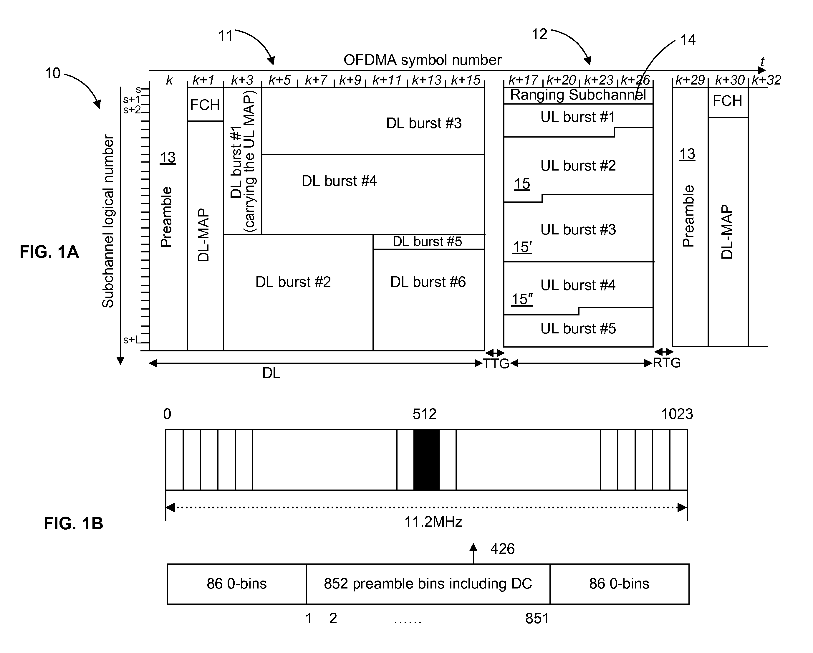
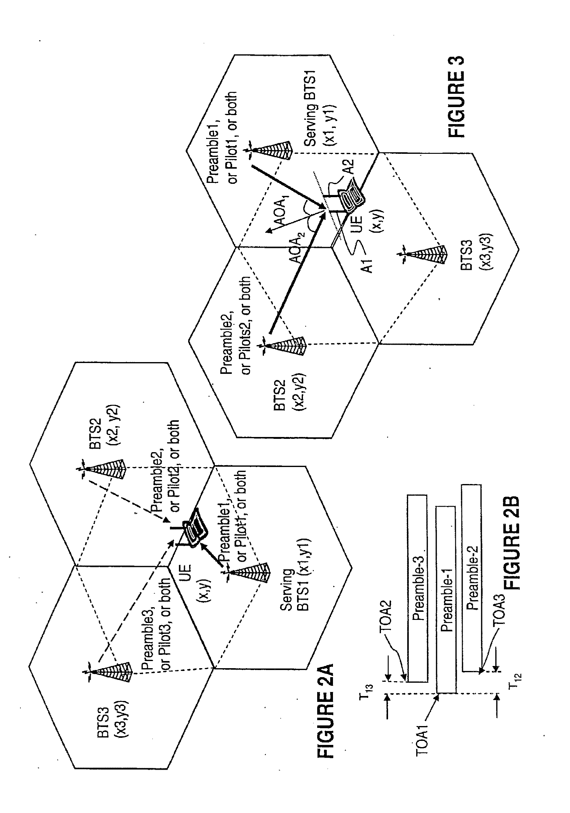
In this specification, the terms “mobile caller” or “caller” is used to designate a user who currently accesses the services offered by a wireless network / services provider. The term “user equipment (UE unit)”, “mobile devices (MD)”, or “mobile station (MS)”, is used to designate wireless-enabled devices such as handsets, phones, notebooks, and other wireless equipment used by subscribers to connect to a wireless or wireline network for exchange of digital or analog formatted information.

The term “base station (BS)” or “base transceiver station (BTS)” refers to the equipment in a wireless access network (WAN) which facilitates wireless access of mobile devices to a wireless or / and wireline communication network. The term “access point (AP)” refers to an indoor access point, which enables connection of indoors UE units to a wireless or a wireline network. BTSs and APs operate in a similar way from the point of view of the present invention, so that the term “BTS” also includes “AP”. ...


PUM


Abstract

A method for calculating the geographical position of a user equipment (UE) unit includes collecting position parameters conveying the relative position of the UE unit from two or more base stations using technologies mandated for the modern wireless networks. Particularly, know (predetermined) signals embedded in the downlink and uplink subframes, such as preambles, pilots, ranging codes are used for determining the coordinates of the UE unit. In addition, the methods and systems proposed here take advantage of the multiple antennas systems mandated at both the UE and BTS.

Description

FIELD OF THE INVENTIONThe invention is directed to mobile radio access systems and in particular to systems and methods for determining the geographical location of a caller operating a mobile (wireless) device over a mobile radio access system.BACKGROUNDWireless networks have significantly impacted the world in the last debacles and their uses continue to grow significantly. People and businesses use wireless networks to send and share data quickly whether it be in a small office building or across the world. Emergency services such as the police department utilize wireless networks to communicate important information quickly. Another important use for wireless networks is as an inexpensive and rapid way for connection to the Internet in countries and regions where the telecom infrastructure is poor or there is a lack of resources, like in many developing countries. One of the latest such wireless technologies is WiMax (Worldwide Interoperability for Microwave Access).A brief revi...

Claims


Application Information

Patent Timeline
Patent Type & Authority Applications(United States)
IPC IPC(8): H04W24/00G01S5/14H04W4/90
CPCG01S5/04H04W64/00G01S5/10
Inventor WU, SHIQUANYEE, JUNG
Owner TAIWAN SEMICON MFG CO LTD
Why Eureka
Try Eureka