Digital map projection

Inactive Publication Date: 2012-04-12
VERIZON PATENT & LICENSING INC
View PDF6 Cites 12 Cited by
  • Summary
  • Abstract
  • Description
  • Claims
  • Application Information

AI Technical Summary

Problems solved by technology

Unfortunately, present mechanisms for projecting Cart

Method used


Image

  • Digital map projection
  • Digital map projection
  • Digital map projection

Examples


Embodiment Construction

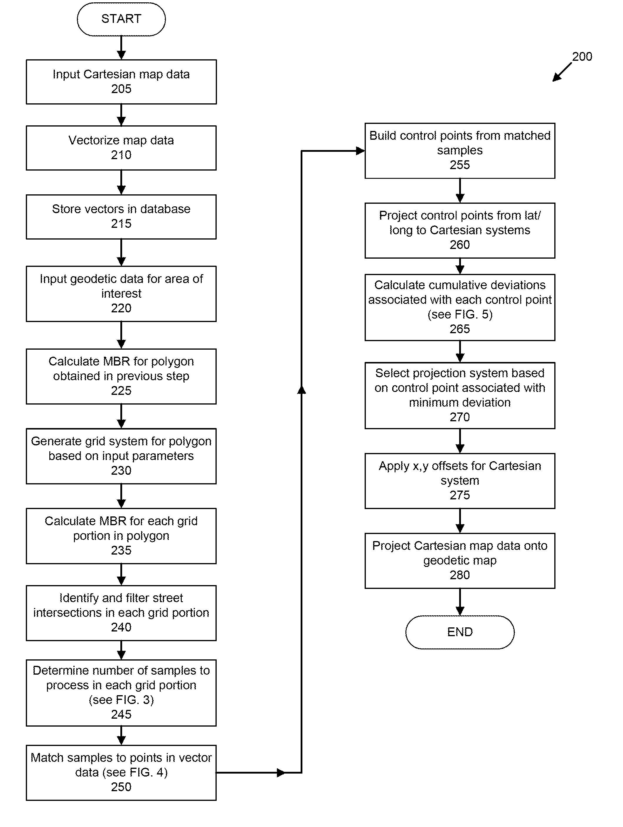
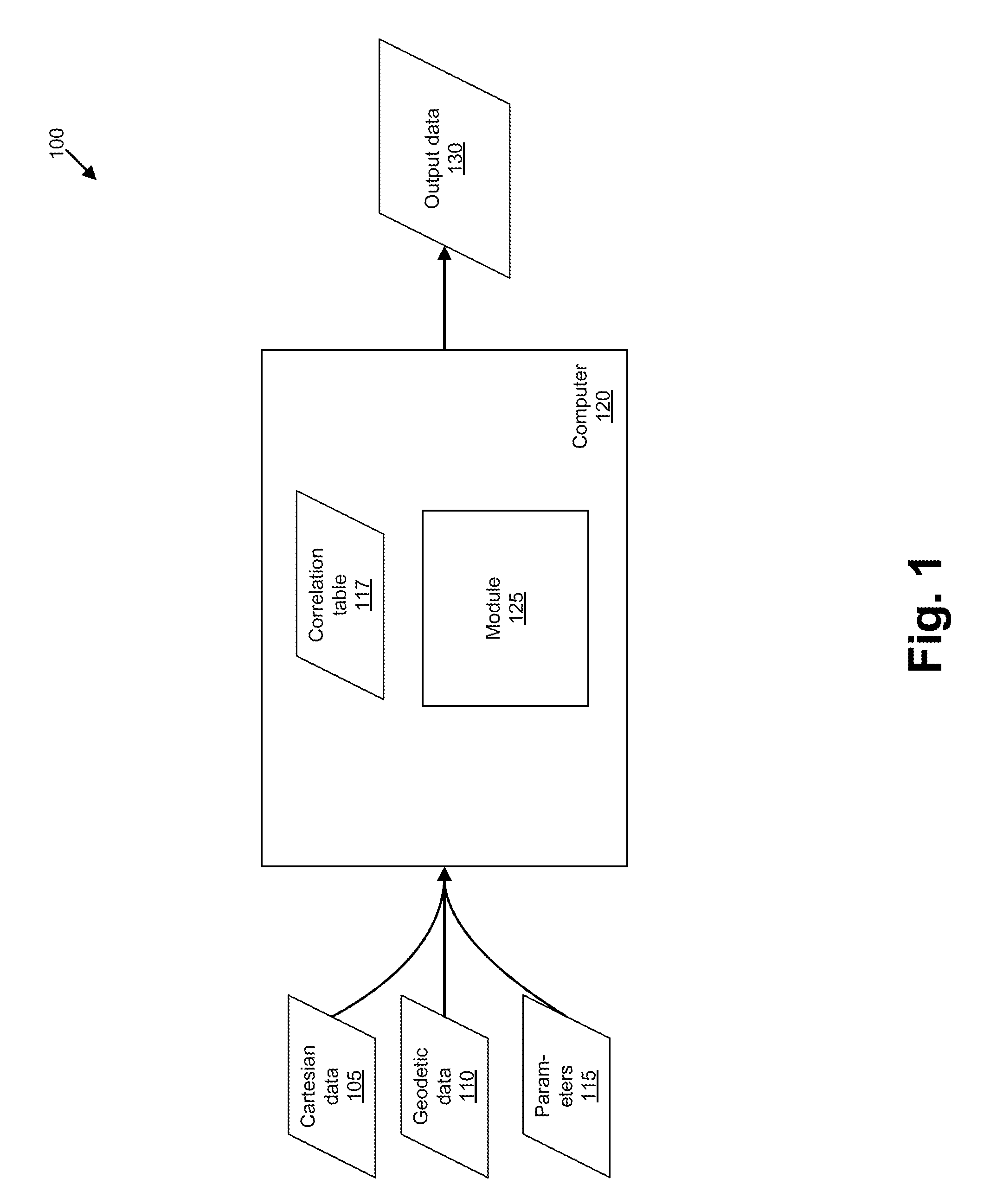
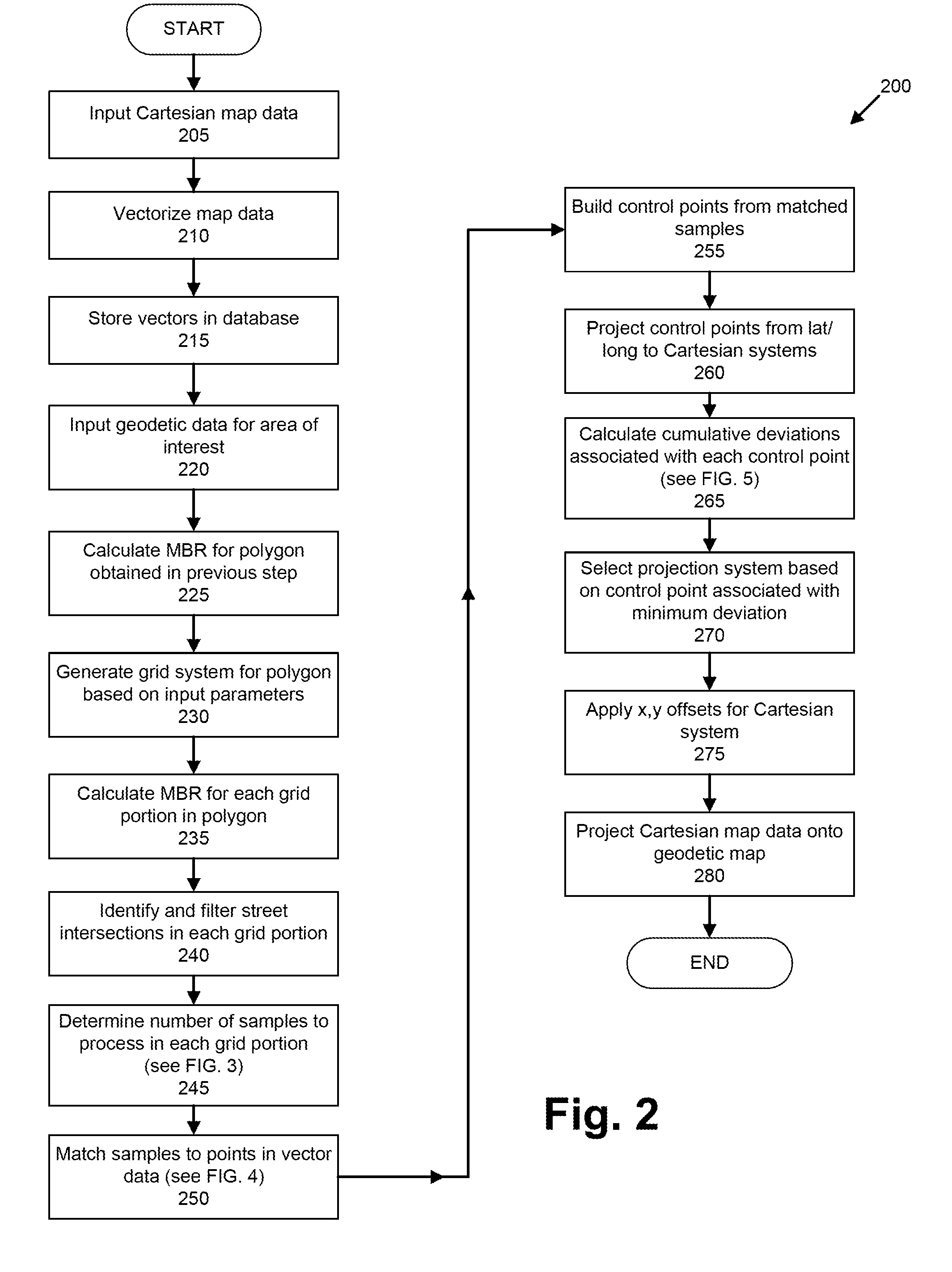
[0009]FIG. 1 illustrates an exemplary system 100 for projecting Cartesian mapping data into a geodetic system. The system 100 includes a computer 120 that generally includes and / or accesses, e.g., via a network, a peripheral cable, a wireless protocol, etc., one or more computer readable media. Cartesian data 105, geodetic data 110, and parameters 115 all may be provided as input to the computer 120 and / or may be stored on the one or more computer readable media included in or accessible by the computer 120. Correlation table 117, which associates UTM and SPC zones with geographic regions, e.g., states and / or counties, etc., is generally stored on a computer-readable medium associated with computer 120. A projection module 125 may include instructions executable by one or more processors included in computer 120, and the module 125 may also be stored on a computer readable medium. Processing by the module 125 may provide output data 130, which in turn may be stored on a computer rea...


PUM


Abstract

A computer receives a set of Cartesian data and a set of geodetic data relating to a geographic area. A set of control points is generated, each control point being associated with a coordinate expressed in terms of latitude and longitude, and with a corresponding point in the Cartesian data. A plurality of sets of Cartesian coordinates is determined for each of the control points, each of the sets of Cartesian coordinates for one of the control points corresponding to a Cartesian system. A deviation is determined for a combination that includes a control point and a Cartesian system, the deviation being a difference between coordinates for the point in the Cartesian data and the set of Cartesian coordinates for the control point. For each set of Cartesian coordinates associated with the Cartesian system that is included in the combination, but further associated with a control point not in the combination, the set of Cartesian coordinates is modified according to the deviation. A cumulative deviation is determined for the combination by determining a sum of distances of each set of modified Cartesian coordinates from the coordinates of the corresponding point in the Cartesian data. Cumulative deviations are thus determined for a plurality of combinations. A combination associated with a minimum cumulative deviation is identified.

Description

BACKGROUND INFORMATION[0001]Geodetic reference systems may be used by the Global Positioning System. Accordingly, mapping data according to a geodetic system may be very useful in a variety of applications. For example, systems using the North American Datum, e.g., the North American Datum of 1927 (NAD27) or the North American Datum of 1983 (NAD83), are geodetic systems. Similarly, the World Geodetic System, which presently uses data according to the WGS 84 and serves as the reference system for the Global Positioning System, is a geodetic system. In a geodetic system, a location is provided with respect to a reference ellipsoid according to latitude, longitude, and height coordinates.[0002]Mapping data may be provided in other formats, e.g., Cartesian formats such as the Universal Transverse Mercator (UTM) or State Plane Coordinate System (SPC or SPCS). In these Cartesian formats, the surface of the earth is divided into zones, and locations in each grid are identified according to...

Claims


Application Information

Patent Timeline
IPC IPC(8): G06F19/00
CPCG09B29/005G01C21/20
Inventor YEH, CHING-YUNANNAMRAJU, KUMARSINGH, ANURAG X.TANUKU, NAGESWARA R.
Owner VERIZON PATENT & LICENSING INC
Why Eureka
Try Eureka