Navigation method, navigation system and map data downloading method for navigation

Inactive Publication Date: 2013-11-14
WISTRON CORP
View PDF16 Cites 28 Cited by
  • Summary
  • Abstract
  • Description
  • Claims
  • Application Information

AI Technical Summary

Benefits of technology

[0020]As mentioned in the above, after the positioning module calculates a coordinate of a current position, the map loading module will take the coordinate to be the center of the predetermined range and calculate a map data within the predetermined range according to the zoom scale of the map scale and then downloads the map data from the map server through the communication module. After the position changes from one to another, the map loading module will take a new coordinate to be the center of the predetermined range and calculate a new map data within the predetermined range according to the zoom scale of the map scale again, downloads the new map data from the map server through the communication module, and replaces the old map data by the new map data. In other words, the invention only downloads partial map data f

Problems solved by technology

However, the aforesaid mobile devices with navigation function usually have some problems as follows: first, map data cannot be updated regularly so that out-of-date map data does not match real road condition; secondly, since map data, which is usually very huge, has to be sto

Method used


Image

  • Navigation method, navigation system and map data downloading method for navigation
  • Navigation method, navigation system and map data downloading method for navigation
  • Navigation method, navigation system and map data downloading method for navigation

Examples


Example

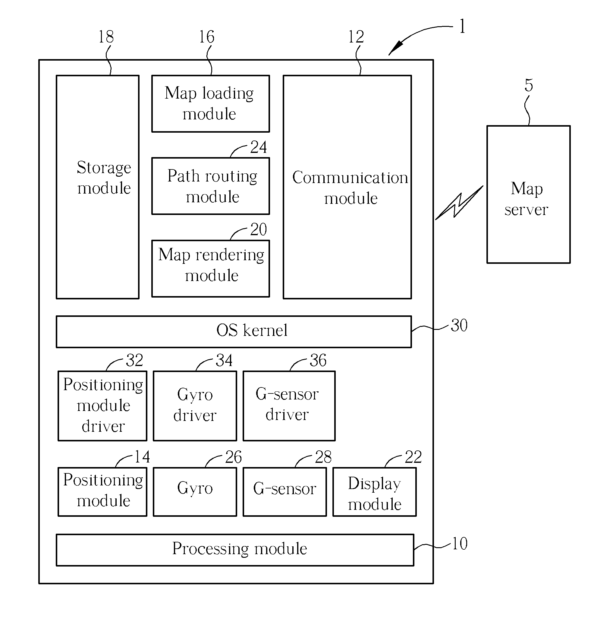
[0029]Referring to FIG. 1, FIG. 1 is a functional block diagram illustrating a navigation system 1 according to an embodiment of the invention. As shown in FIG. 1, the navigation system 1 comprises a processing module 10, a communication module 12, a positioning module 14, a map loading module 16, a storage module 18, a map rendering module 20, a display module 22, a path routing module 24, a gyro 26, a g-sensor 28, a operating system (OS) kernel 30, a positioning module driver 32, a gyro driver 34 and a g-sensor driver 36.

[0030]In practical applications, the navigation system 1 may be a smart phone, a navigation device or other electronic devices with satellite positioning function and communication function; the processing module 10 may be a central processing unit (CPU); the communication module 12 may be Bluetooth, WiFi, 3G or other wireless communication modules; the positioning module 14 may be a GPS module or other satellite positioning modules; the storage module 18 may be a...


PUM


Abstract

A navigation method includes steps of calculating a first coordinate of a first position; taking the first coordinate to be a center of a predetermined range and calculating a first map data within the predetermined range according to a zoom scale of a map scale; downloading the first map data from a map server; storing the first map data; using the first map data to render a first graphic user interface map corresponding to the first coordinate; and displaying the first graphic user interface map.

Description

BACKGROUND OF THE INVENTION[0001]1. Field of the Invention[0002]The invention relates to a navigation method and a navigation system and, more particularly, to a map data downloading method capable of reducing a capacity required for storing map data for navigation effectively.[0003]2. Description of the Prior Art[0004]As global position system (GPS) and various mobile devices (e.g. smart phone) advance and develop, navigation function performed on mobile devices has been improved and diversified accordingly. So far there have been lots of mobile devices with built-in navigation software, which uses a path routing software engine with built-in map data to calculate an optimal path so as to guide a user to a destination according to the optimal path. However, the aforesaid mobile devices with navigation function usually have some problems as follows: first, map data cannot be updated regularly so that out-of-date map data does not match real road condition; secondly, since map data, ...

Claims


Application Information

Patent Timeline
IPC IPC(8): G01C21/34G01C21/26
CPCG01C21/3889G01C21/3896
Inventor KUO, TSAI-YUANCHEN, LIAN-CHIHLIANG, CHIA-MINGHUANG, CHI-FA
Owner WISTRON CORP
Why Eureka
Try Eureka