Airborne satellite communications system

a satellite communications and airborne technology, applied in the field of satellite communications systems, can solve the problems of increasing complexity and no easy task of operationally maintaining the data path

Inactive Publication Date: 2013-11-21
COSO CLOUD LLC
View PDF1 Cites 2 Cited by
  • Summary
  • Abstract
  • Description
  • Claims
  • Application Information

AI Technical Summary

Benefits of technology

[0005]In accordance with the present invention, a system is provided for use in connecting a LAN into a satellite communications network. Specifically, the system is provided to establish a central management interface between the electronic components that interchange operational data. In particular, this interchange of data is accomplished by the system to control the components that establish and maintain a data path between the LAN and a satellite. As envisioned for the present invention the system will be mounted on a moving vehicle that may either be airborne, terrestrial or maritime.
[0006]Components for the system of the present invention include a services platform, an antenna assembly, an Antenna Control Unit (ACU), an Inertial Reference Unit (IRU) and a modem. For communication purposes, the antenna assembly is connected to the modem, and the modem is connected with the services platform. In turn, the services platform is connected to the LAN. Thus, the LAN is connected in communication with the antenna assembly. On the other hand, for control purposes, the antenna assembly is connected with the ACU, and the ACU is connected via the services platform with the IRU. Thus, the antenna assembly is operationally controlled by the ACU to establish and maintain a communication data path between the LAN and a satellite.
[0007]For operational control of the antenna assembly, the IRU generates parametric values that are transferred by the services platform for input to the ACU. More specifically, these parametric values are indicative of both a spatial attitude of the moving vehicle (e.g. pitch, roll and yaw), and a location of the moving vehicle (e.g. position, altitude and velocity). Typically, the location information can be provided by a GPS capability. In the event of a GPS failure, however, the system of the present invention can revert to inertial sensing techniques for its location information.
[0008]In operation, under control from the services platform, the ACU converts input from the IRU into antenna orientation parameters. More specifically, based on inputs from the IRU, the antenna assembly is dynamically oriented by the ACU in response to movements of the vehicle. Thus, movements of the antenna assembly are controlled with appropriate elevation, azimuth and polarization inputs to establish a data path between the antenna and the satellite. At the same time, also under control from the services platform, system signals will be converted between Ku-band (used on the data path between the moving vehicle and the satellite) and L-band (between the LAN and the modem and between the modem and the antenna). Further, the services platform and modem encode / decode and assemble / disassemble data. The services platform will also direct data transmissions in the LAN.

Problems solved by technology

Not surprisingly, this is no easy task.
Moreover, the ability to operationally maintain the data path becomes increasingly complex when the LAN is mounted on a moving vehicle.

Method used


Image

  • Airborne satellite communications system
  • Airborne satellite communications system

Examples


Embodiment Construction

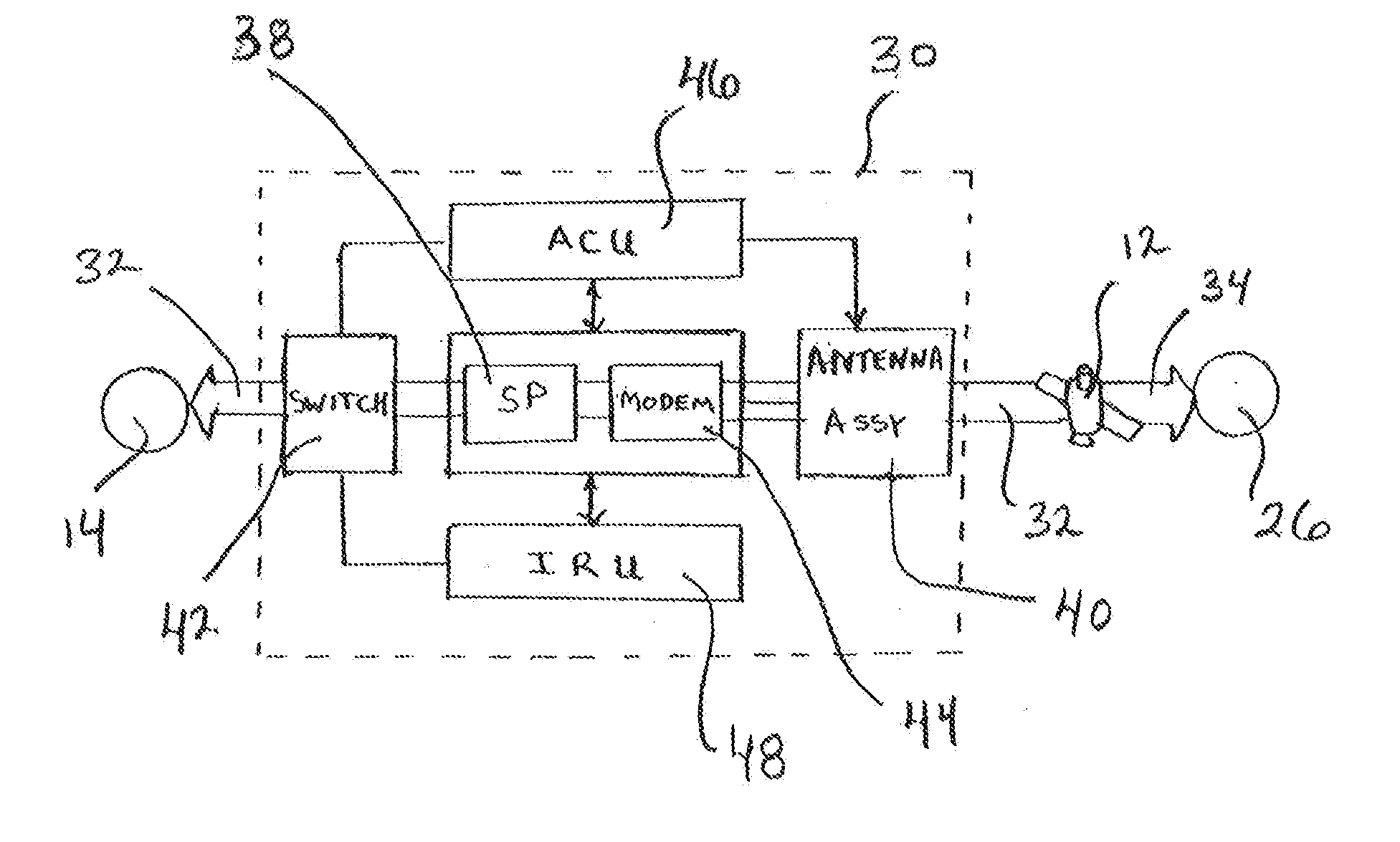
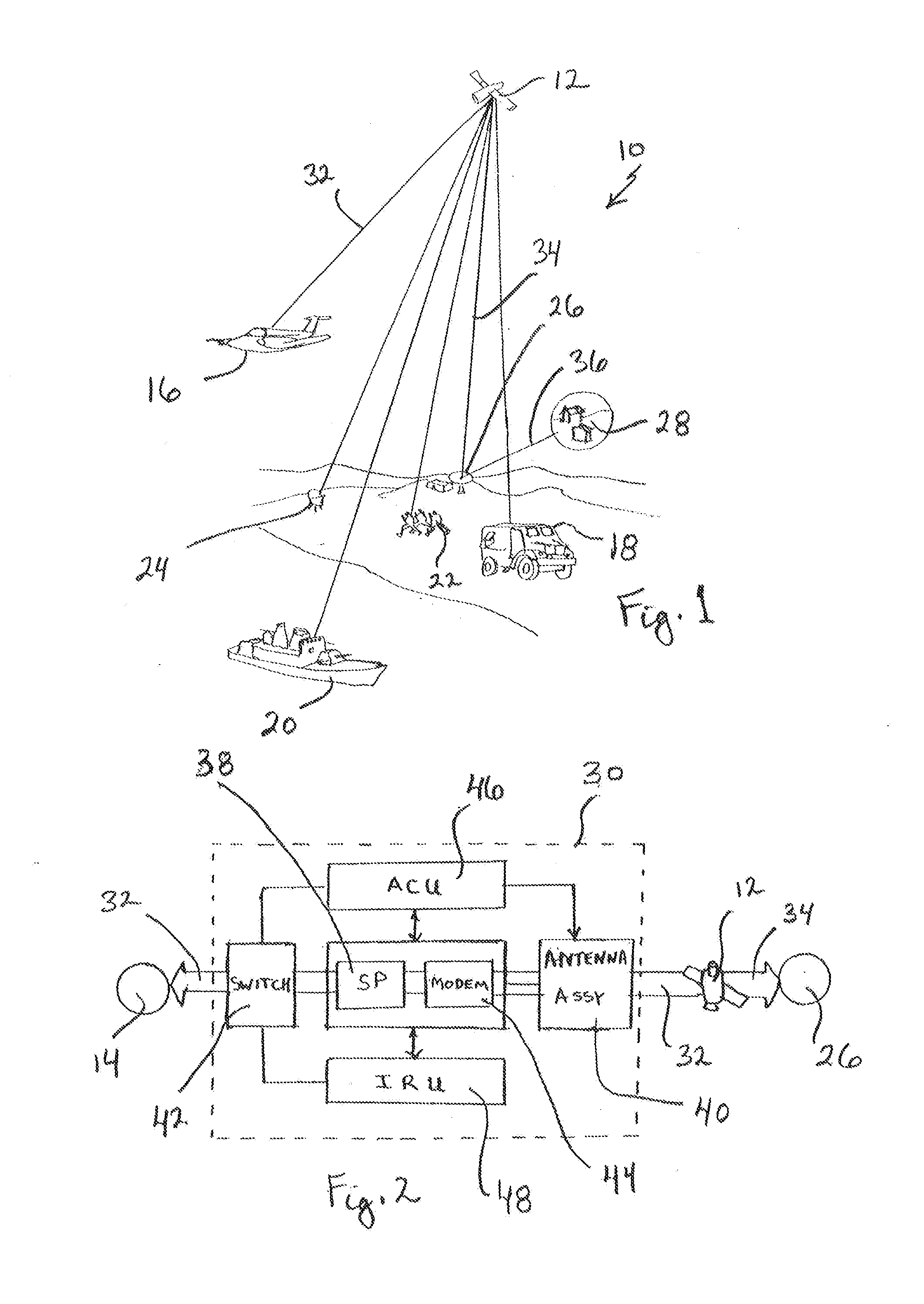
[0012]Referring initially to FIG. 1 an environment for implementing the present invention is shown and is generally designated 10. As shown, a satellite 12 is used to establish a communication link with a Local Area Network (LAN) 14 [see FIG. 2] which can be variously located on a moving vehicle in the environment 10. For instance, a LAN 14 can be carried on an airborne vehicle 16, a terrestrial vehicle 18 or a maritime vehicle 20. As envisioned for the present invention, the airborne vehicle 16 may be an airplane (as shown), or it may be a rocket, a balloon, a helicopter or a pilotless drone. Further, the terrestrial vehicle 18 may be a truck (as shown), or it may be any other form of land transportation. Additionally, the maritime vehicle 20 may be a ship (as shown), or any other form of seaborne transportation. Also, a LAN 14 may be carried by personnel 22 or connected with a mobile base 24. In each case there will be a communication link between a respective LAN 14 and the satel...


PUM


Abstract

A system is provided to establish and maintain a data path between a Local Area Network (LAN) that is mounted on a moving vehicle and a satellite. In combination, an antenna assembly, an Antenna Control Unit (ACU), an Inertial reference Unit (IRU), and a modem are mounted together on the moving vehicle, under the overall control of a services platform. Operationally, the IRU generates parametric values indicative of the spatial attitude and location of the moving vehicle. The ACU then uses the parametric values to aim the antenna in a direction toward the satellite. In this combination, the modem is connected with the antenna to transmit and receive data between the system and the satellite. Individually or collectively, operationally compatible components of the system (IRU, ACU, antenna and modem) can be appropriately substituted to thereby customize the system.

Description

FIELD OF THE INVENTION[0001]The present invention pertains generally to satellite communications systems. More particularly, the present invention pertains to satellite communications systems wherein a Local Area Network (LAN) is mounted on a moving vehicle. The present invention is particularly, but not exclusively, useful in a satellite communications system wherein the combination of components for communication and antenna control can be customized for operational compatibility, to thereby establish and maintain a data path between the moving vehicle and the satellite.BACKGROUND OF THE INVENTION[0002]Satellite communications systems rely on the ability of a LAN to establish and maintain a data path between the station and the satellite. Not surprisingly, this is no easy task. Moreover, the ability to operationally maintain the data path becomes increasingly complex when the LAN is mounted on a moving vehicle. Accordingly, the operational control of an antenna assembly that is su...

Claims


Application Information

Patent Timeline
Patent Type & Authority Applications(United States)
IPC IPC(8): H01Q3/00
CPCH01Q1/125H01Q1/32
Inventor MURI, MARK E.CARIDES, PETER ALEXANDERDICKHOVEN, SIMON H.JANOV, MARC S.ROBBINS, BARRY R.
Owner COSO CLOUD LLC
Why Eureka
Try Eureka