Positioning accuracy using 3D building models

a technology of building models and positioning accuracy, applied in the field of global positioning systems, can solve the problems of inaccurate time measurement, affecting the accuracy of mobile device's estimation of the distance of each satellite, and affecting the accuracy of mobile device's estimation of geographic coordinates,

Active Publication Date: 2015-11-05
APPLE INC
View PDF3 Cites 20 Cited by
  • Summary
  • Abstract
  • Description
  • Claims
  • Application Information

AI Technical Summary

Problems solved by technology

The term pseudoranges is used to refer to such distances because there the time measured might be inaccurate.
However, in an urban environment in which tall buildings surround a mobile device, the signals that the mobile device detects from various satellites might not be direct line-of

Method used


Image

  • Positioning accuracy using 3D building models
  • Positioning accuracy using 3D building models
  • Positioning accuracy using 3D building models

Examples


Embodiment Construction

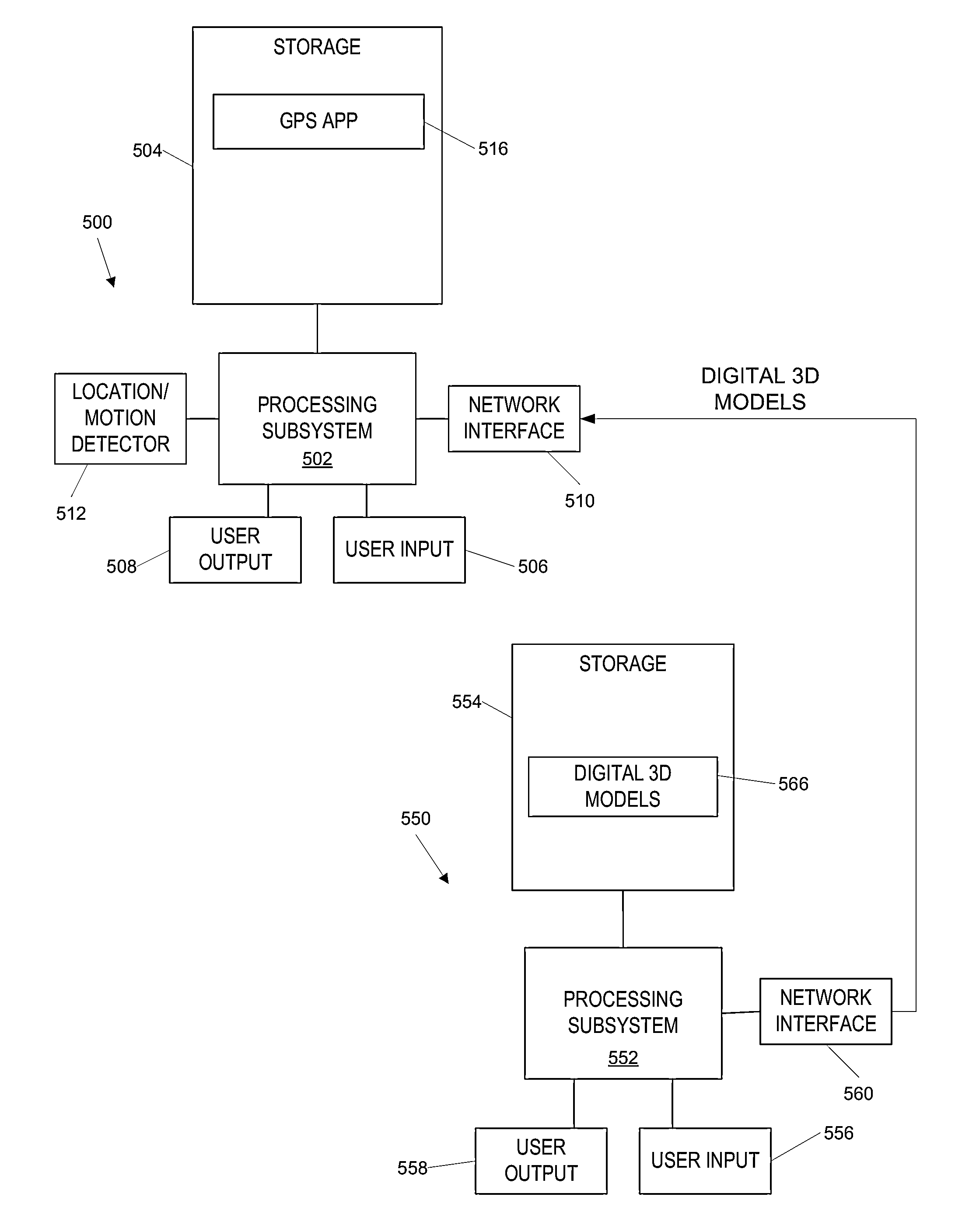
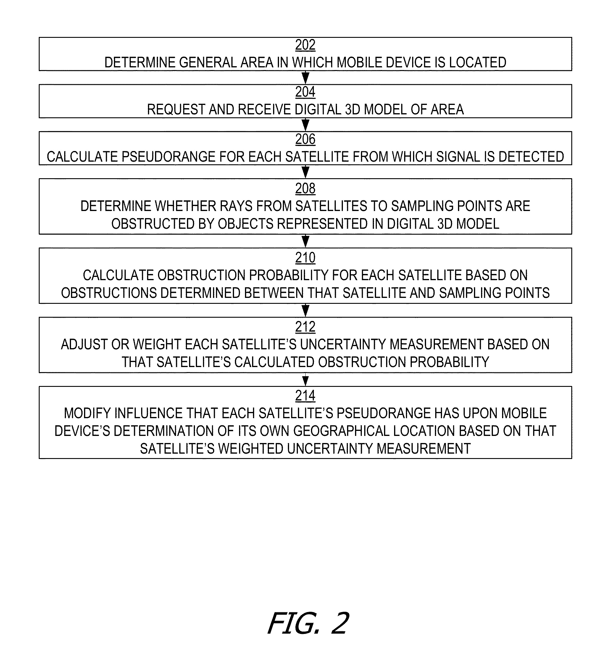
[0012]Using techniques disclosed herein, a mobile device such as a smart phone can use a digital 3D model of the environment in which the mobile device is generally predicted to be in order to determine which lines-of-sight from various satellites are likely to be obstructed by buildings or other objects in that environment.

Determining Occluded Signals Using a Digital 3D Model

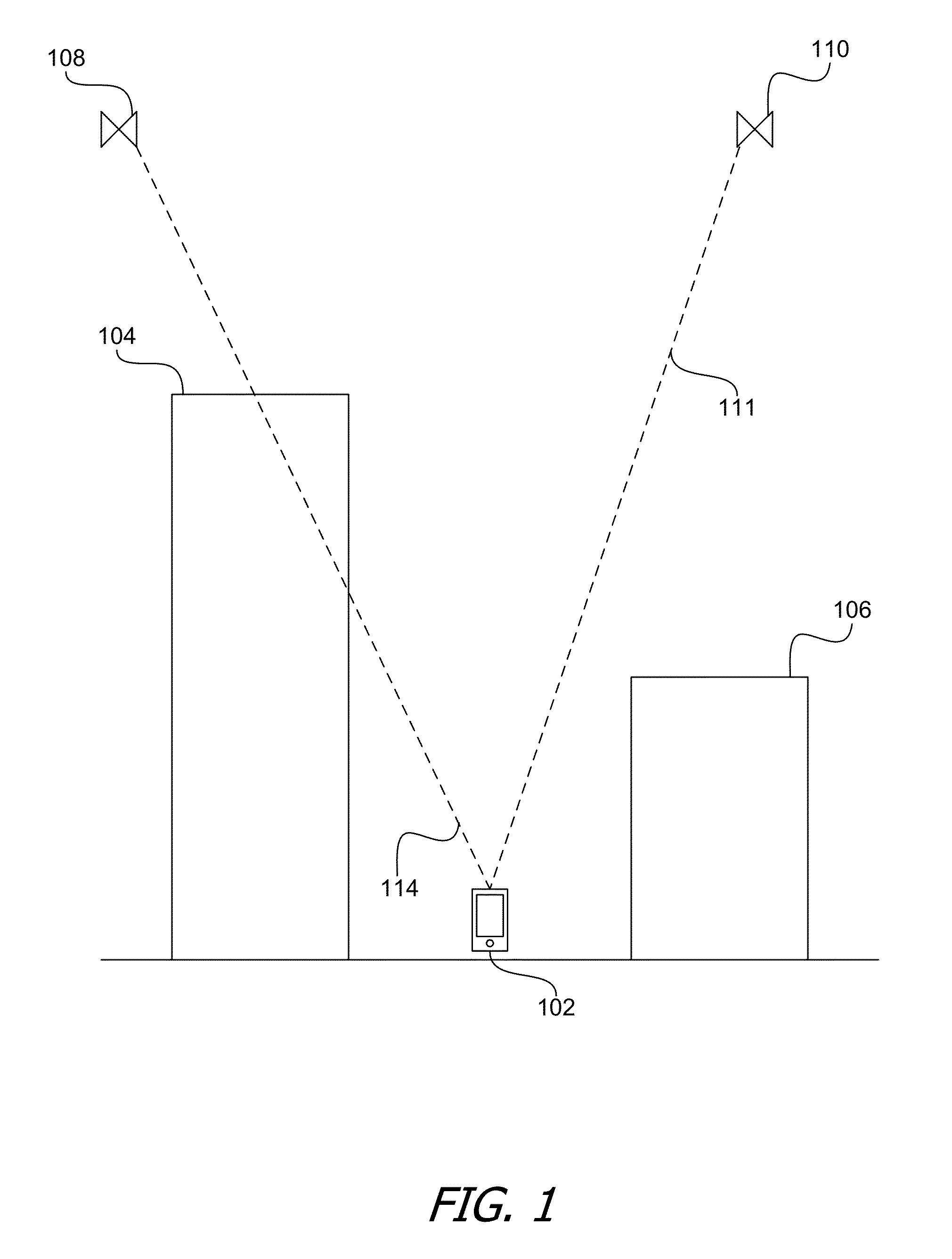
[0013]FIG. 1 is a diagram that illustrates a mobile device in an urban environment where some direct line-of-sight signals from some satellites may be obstructed by buildings or other objects. As shown in FIG. 1, a mobile device 102 is actually located at ground-level on a street in between two buildings 104 and 106. However, although mobile device 102 might possess information that places mobile device 102 somewhere in the vicinity of buildings 104 and 106, mobile device 102 might not be able to estimate its position with high accuracy without relying on signals that mobile device 102 receives from one or more...


PUM


Abstract

A mobile device adjusts the extents to which it depends on various satellites to estimate its global position based on the predicted probability for each such satellite that a ray extending from that satellite to the mobile device is obstructed by a building. The mobile device can predict the probabilities of building obstructions based on a digital model of the environment in which the mobile device is estimated to be. The mobile device weights the extent of uncertainty for each satellite's global positioning data based on the predicted probability of obstruction for that satellite. Using these weighted uncertainties, the mobile device selects the extents to which it relies on each satellite's global positioning data when estimating the mobile device's current global position.

Description

CLAIM OF PRIORITY[0001]The present application claims priority under 35 U.S.C. §119(e) to Provisional U.S. Patent Application Ser. No. 61 / 988,027, filed May 2, 2014, and titled “IMPROVED POSITIONING ACCURACY USING 3D BUILDING MODELS.” The contents of Provisional U.S. Patent Application Ser. No. 61 / 988,027 are incorporated by reference herein.BACKGROUND[0002]Techniques disclosed herein pertain generally to the field of global positioning systems, and more specifically to techniques for improving the accuracy of mobile device location estimation using satellite signals. Mobile devices, such as smart phones, typically come equipped with global positioning systems that enable those devices to estimate their geographical coordinates based on signals received from various satellites. A mobile device can compute the position of a Global Navigation Satellite System (GNSS) satellite using satellite ephemeris information and a time estimate. A mobile device also can compute an azimuth and ele...

Claims


Application Information

Patent Timeline
IPC IPC(8): H04W64/00H04W4/02H04B17/40H04W4/20
CPCH04W64/00H04W4/023H04B17/40G01S19/28H04B7/18519H04W4/025H04W4/20H04W4/02
Inventor MACGOUGAN, GLENN D.MAYOR, ROBERT W.CHHOKRA, KUMAR
Owner APPLE INC
Why Eureka
Try Eureka