Unlock instant, AI-driven research and patent intelligence for your innovation.

Electronic map with directional rendering method and system

Inactive Publication Date: 2016-02-04
ZB TECH CO LTD
View PDF0 Cites 0 Cited by
  • Summary
  • Abstract
  • Description
  • Claims
  • Application Information

AI Technical Summary

Benefits of technology

The present invention is a method and system for rendering electronic maps that only display service providers on driving routes or navigation directions to avoid unnecessary information. The system uses numbers or symbols to guide users to find the closest service provider. The invention includes an electronic map database with information about streets and service providers, as well as a planning module to generate driving routes based on user-defined starting and destination positions or directions. Overall, the invention provides a more efficient and effective way to display relevant service providers on electronic maps.

Problems solved by technology

However, the rapid development of cities has brought about the growing complexity of road connections.
Hence, the means to make full use of the roads to quickly reach a destination is an important issue.
However, as for devices that lack navigational functions, such as smart mobile phones that only provide an electronic map as the main service provider, when the user wants to inquire about gasoline stations, the electronic map service is only able to display the locations of all gas stations, causing the entire screen image to be extremely cluttered.
At best, such devices can limit the query to gas stations in the vicinity of a certain road, however, they do not provide services that integrate with route plans.

Method used


Image

  • Electronic map with directional rendering method and system
  • Electronic map with directional rendering method and system
  • Electronic map with directional rendering method and system

Examples


Embodiment Construction

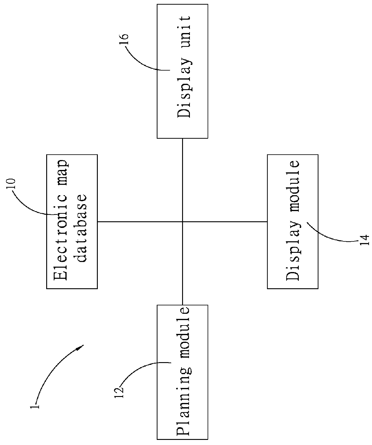
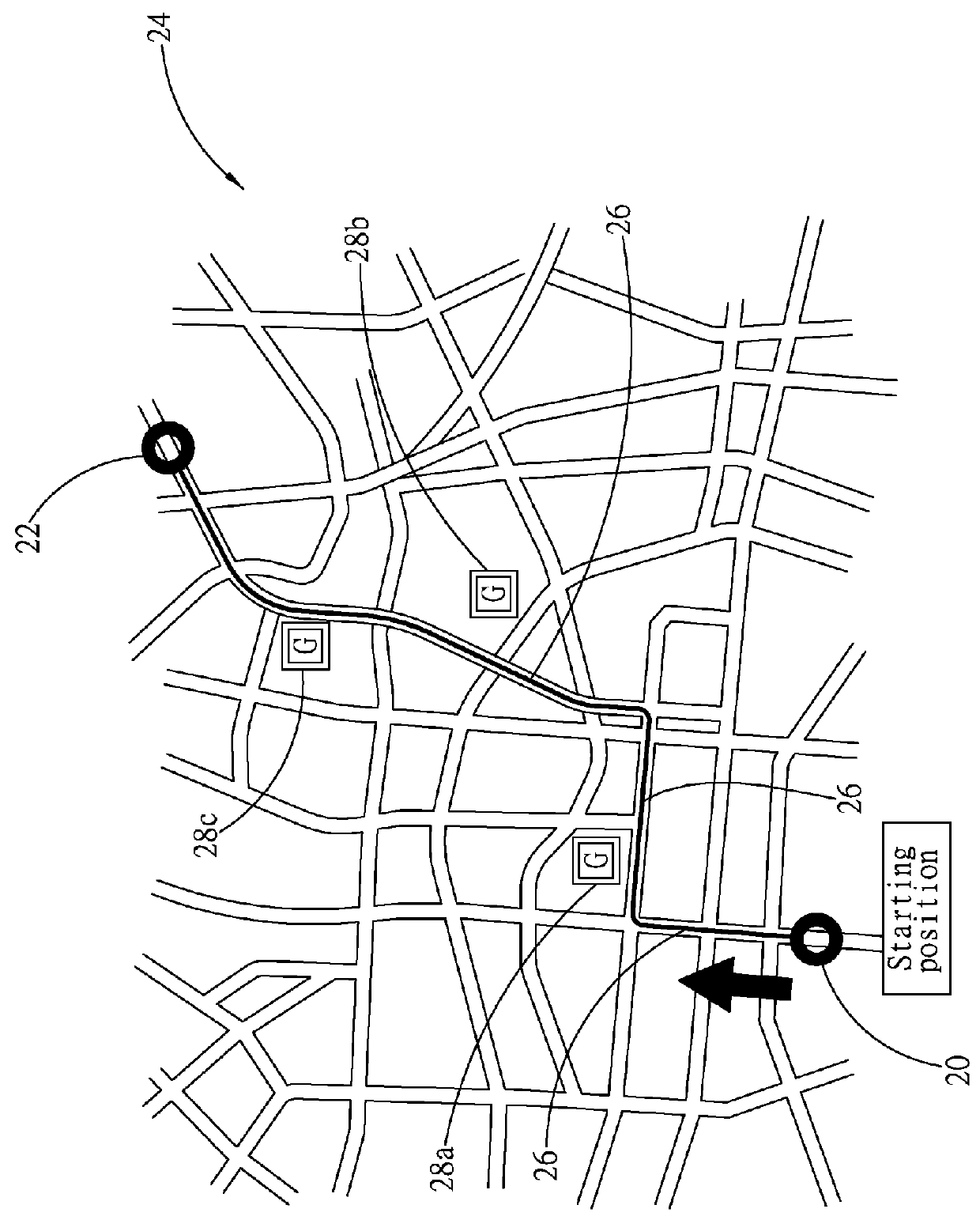
[0015]Referring to FIG. 1, which shows a schematic view of an electronic map rendering system of the present invention, wherein an electronic map rendering system 1 of the present invention primarily comprises an electronic map database 10, a planning module 12, and a display module 14. The electronic map database 10 primarily comprises a plurality of street data and position information of a plurality of service providers adjacent to the plurality of streets. After the user sets a starting position and a destination position through a touch display unit 16 or other input means, then the planning module 12 is able to plan a driving route (primarily from the plurality of streets passed through from the starting position to the destination position) according to the starting position and the destination position or direction based on the street data provided by the electronic map database 10. Then the display module 14 obtains position information of a plurality of service providers a...


PUM


Abstract

In an electronic map rendering method and system of the present invention, the electronic map rendering system includes an electronic map database, a planning module, and a display module. The electronic map database includes a plurality of street data, and position information of a plurality of service providers adjacent to a plurality of streets. After setting a starting position and a destination position or through detection of the traveling direction, the system is able to plan a driving route. After which, position information is then obtained of a plurality of service providers in the electronic map database closest to the driving route.

Description

BACKGROUND OF THE INVENTION[0001](a) Field of the Invention[0002]The present invention relates to a rendering method and system, and more particularly to an electronic map rendering method and system.[0003](b) Description of the Prior Art[0004]Following the prevalence of the automobile industry, means of transportation such as automobiles, and the like, have become one of the most important inventions in the progress of modern times. The ability of the automobile to quickly transport people is equivalent to shrinking the distance between people. However, the rapid development of cities has brought about the growing complexity of road connections. Hence, the means to make full use of the roads to quickly reach a destination is an important issue.[0005]The birth of the Global Positioning System (hereinafter referred to as GPS) has brought great convenience for a great number of people, relieving them, as long as they have a GPS navigation system, of the worry about getting lost or oth...

Claims


Application Information

Patent Timeline
IPC IPC(8): G01C21/36G01C21/34
CPCG01C21/3476G01C21/3644G01C21/3682
Inventor YEH, BRIAN
Owner ZB TECH CO LTD