Enhanced conversion between geohash codes and corresponding longitude/latitude coordinates

a technology of longitude/latitude coordinates and geohash codes, applied in the field of electrical, electronic and computer arts, can solve the problems of geohash codes not replacing latitude/longitude coordinates, data is increasing at an unprecedented rate, and the amount of available spatial data is small

Inactive Publication Date: 2016-09-29
IBM CORP
View PDF2 Cites 15 Cited by
  • Summary
  • Abstract
  • Description
  • Claims
  • Application Information

AI Technical Summary

Benefits of technology

[0005]Principles of the invention, in accordance with one or more embodiments thereof, provide techniques for high-speed and flexible conversion between geohash codes and corresponding latitude/longitude coordinates. In one aspect, an exemplary apparatus for converting between a geohash code and latitude/longitude coordinates includes a conversion module operative in one of at least first and second modes. In the first mode, the conversion module is adapted to receive a geohash code, a number of geohash code bits remaining to be processed and an initial input interval, and being configured to generate first and second output intervals that are updated after each geohas

Problems solved by technology

One significant challenge posed by processing spatial queries is the sheer amount of available spatial data; the volume of such data is increasing at an unprecedented rate, primarily attributable to the widespread use of GPS-enabled

Method used


Image

  • Enhanced conversion between geohash codes and corresponding longitude/latitude coordinates
  • Enhanced conversion between geohash codes and corresponding longitude/latitude coordinates
  • Enhanced conversion between geohash codes and corresponding longitude/latitude coordinates

Examples


Embodiment Construction

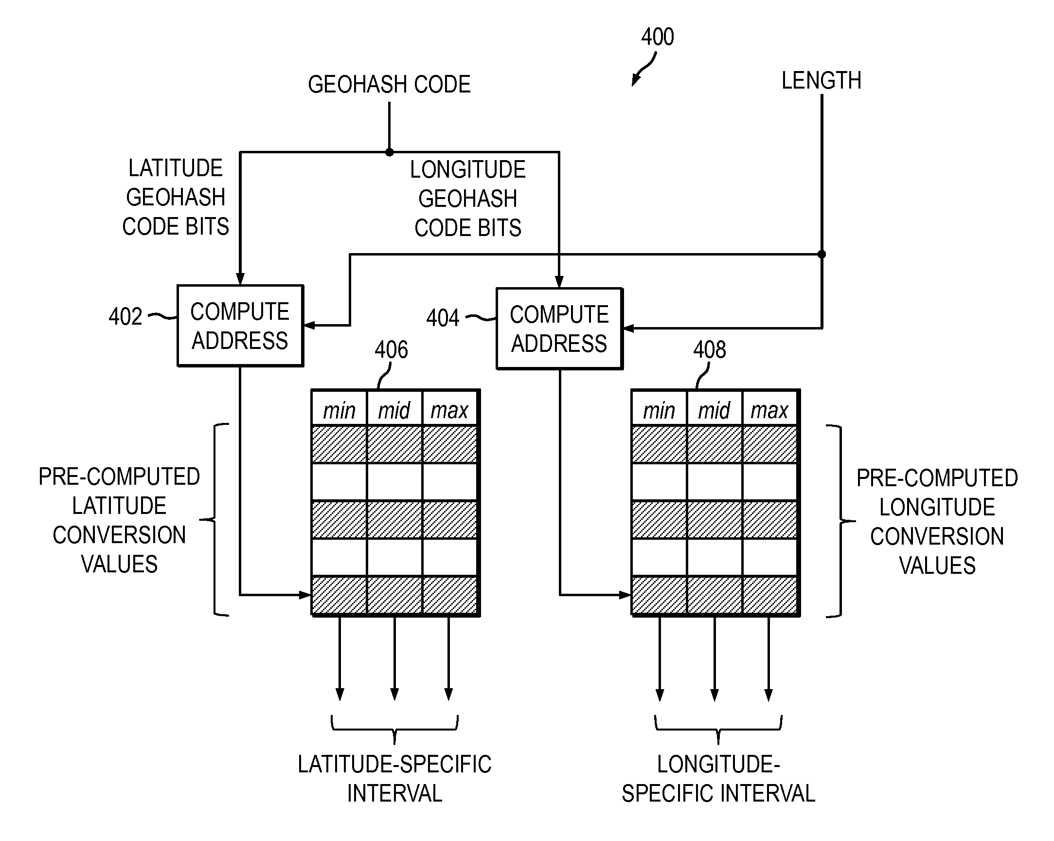
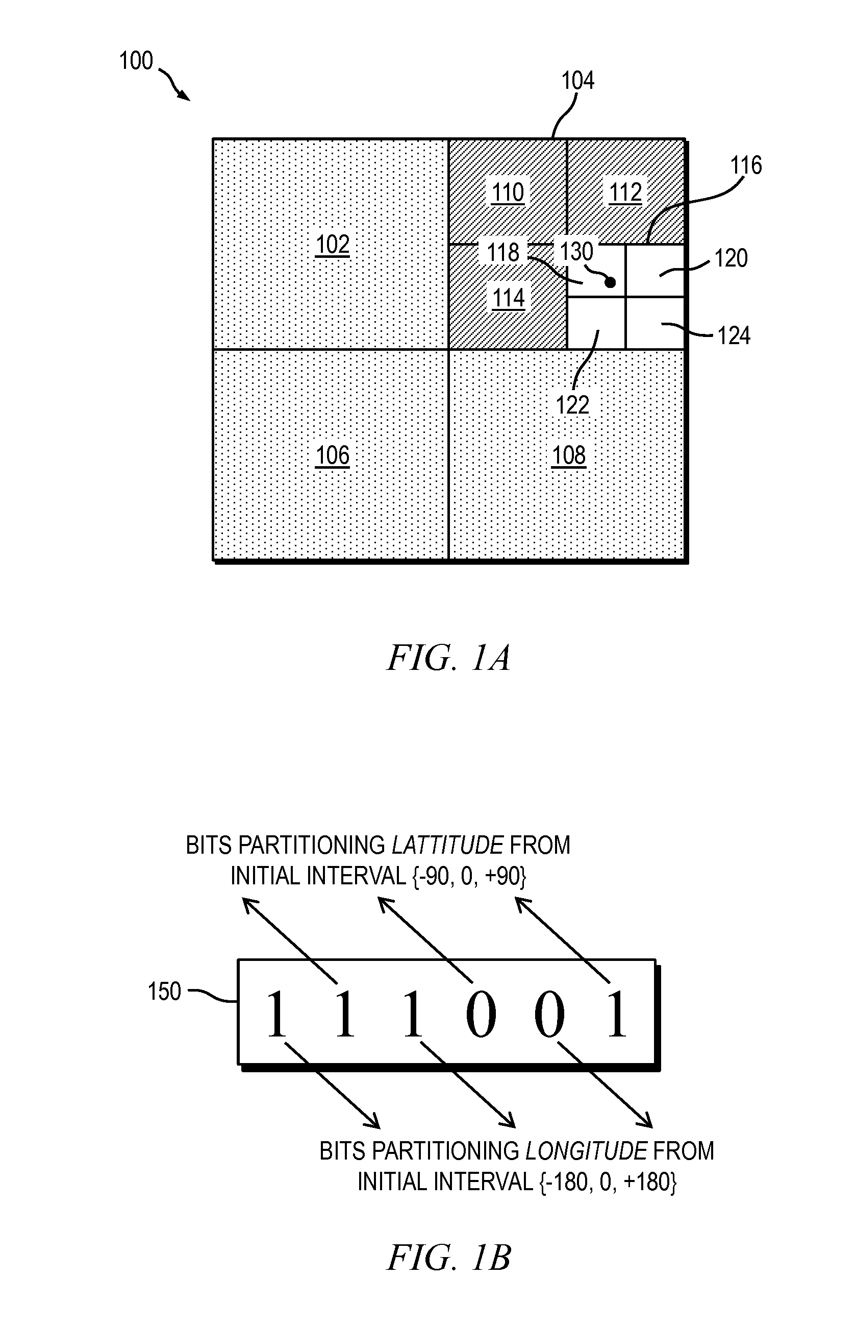
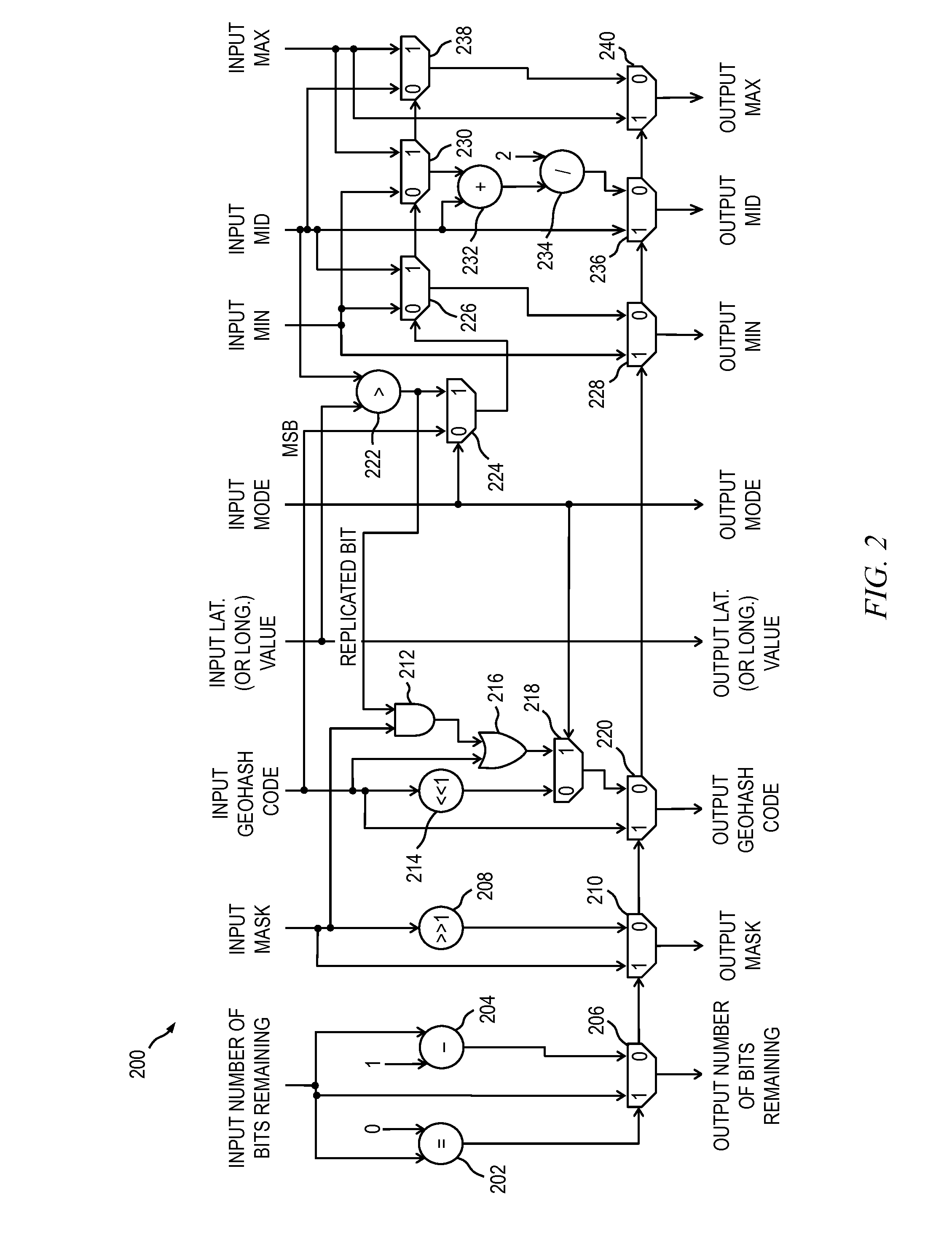
[0025]Principles of the present invention will be described herein in the context of an illustrative bidirectional geohash conversion engine for performing fast and flexible conversion of geohash codes to and from latitude / longitude coordinates. It is to be appreciated, however, that the invention is not limited to the specific apparatus and / or methods illustratively shown and described herein. Rather, aspects of the present disclosure relate more broadly to methods and apparatus for performing enhanced conversion between geohash codes and corresponding latitude / longitude coordinates. Moreover, it will become apparent to those skilled in the art given the teachings herein that numerous modifications can be made to the embodiments shown that are within the scope of the claimed invention. That is, no limitations with respect to the embodiments shown and described herein are intended or should be inferred.

[0026]As previously stated, with the growing use of embedded location-sensing dev...


PUM


Abstract

An apparatus for converting between a geohash code and latitude/longitude coordinates includes a conversion module operative in one of at least first and second modes. In the first mode, the conversion module receives a geohash code, a number of geohash code bits remaining to be processed and an initial input interval, and generates first and second output intervals that are updated after each geohash code bit processed. The latitude and longitude coordinates are generated based on the first and second output intervals, respectively. In the second mode, the conversion module receives a latitude or longitude value, the number of geohash code bits remaining to be processed and the initial input interval, and generates a given one of the first and second output intervals. The conversion module is configured to process data at a rate of one geohash code bit per hardware cycle.

Description

BACKGROUND OF THE INVENTION[0001]The present invention relates generally to the electrical, electronic and computer arts, and, more particularly, to geographical information management.[0002]The ubiquitous availability of location sensing devices embedded in smartphones, vehicles, and other devices, combined with the ability to collect data at scale, enables fine-grained monitoring and modeling of human movement, both at an individual level and at a group level. Using trajectory data harvested by global positioning systems (GPS), radio frequency identification (RFID) and mobile devices, complex pattern queries can be posed against objects moving in both time and space. Answering these queries introduces opportunities for business intelligence, where prediction regarding future patterns can be used to solve challenging problems such as, but not limited to, traffic congestion prediction, crime pattern analysis and prediction, epidemic spread characterization and alerting, insurance pr...

Claims


Application Information

Patent Timeline
IPC IPC(8): G06F17/30G01S19/42
CPCG06F17/30241G01S19/42G06F17/30424G01S19/13
Inventor MOUSSALLI, ROGERASAAD, SAMEH W.SRIVATSA, MUDHAKAR
Owner IBM CORP
Why Eureka
Try Eureka