Emergency Vehicle Locator

a technology for emergency vehicles and locators, applied in the direction of navigation instruments, instruments, wireless commuication services, etc., can solve the problems of inability to determine the location of vehicles in relation to their own, drivers cannot immediately determine the best course of action, etc., and achieve the effect of low cost and high reliability

Active Publication Date: 2017-09-21
BRETON MAXWELL JOSEPH
View PDF0 Cites 17 Cited by
  • Summary
  • Abstract
  • Description
  • Claims
  • Application Information

AI Technical Summary

Benefits of technology

[0008]A low-cost, GPS-based system for simultaneously displaying the location of one's vehicle and nearby emergency vehicles on a moving map display is described herein. This system is designed to be low enough in cost and highly reliable, making it deployable in large numbers in vehicles.

Problems solved by technology

Drivers of vehicles often hear emergency vehicles but cannot determine their locations in relation to their own vehicle.
Therefore drivers cannot immediately determine the best course of action for avoiding the path of approaching emergency vehicles.
This can create a delay or safety hazard for both vehicles and for drivers and passengers of nearby vehicles.
Resulting confusion and uncertainty also leads to less efficient traffic flow when emergency vehicles are heard by a driver but not yet seen by the driver.
Drivers of vehicles with built-in GPS receivers and drivers with mobile phone or other mobile based GPS receivers can see the locations of their vehicles on their moving map displays but they cannot see the locations of emergency vehicles on the same display, even when their presence is known because of their audible sirens and flashing lights.

Method used


Image

  • Emergency Vehicle Locator
  • Emergency Vehicle Locator
  • Emergency Vehicle Locator

Examples


Embodiment Construction

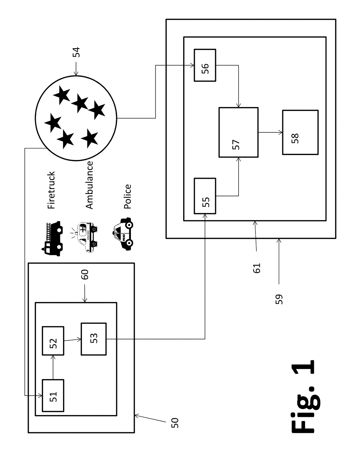
[0016]An exemplary embodiment of the invention is shown in FIG. 1. An emergency vehicle 50, e.g. a fire truck, an ambulance, or a police car has an on-board Location Broadcasting System (LBS) 60 comprised of a Global Positioning System (GPS) receiver 51, a Bluetooth beacon 53, and a communication means 52. The GPS receiver 51 receives broadcasts from the GPS constellation 54 satellites in the normal manner for this well-known technology and determines the geo-location of the host emergency vehicle 50.

[0017]The communication means 52 transfers the location data from the GPS receiver 51 to the Bluetooth beacon 53. The Bluetooth beacon 53 broadcasts a radio signal containing identifying information about the type of its host emergency vehicle, e.g. fire truck, ambulance, or police car, and the location data from the GPS receiver 51 throughout the local geographic area.

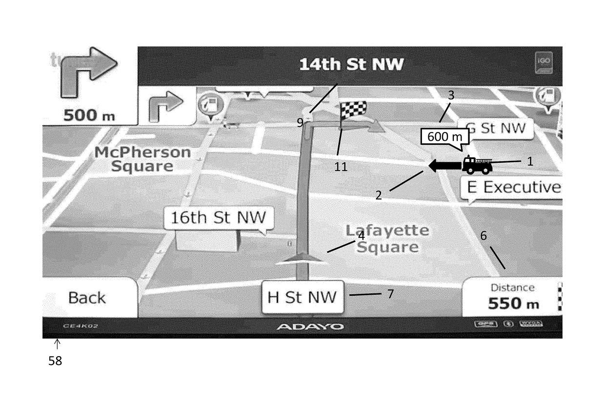
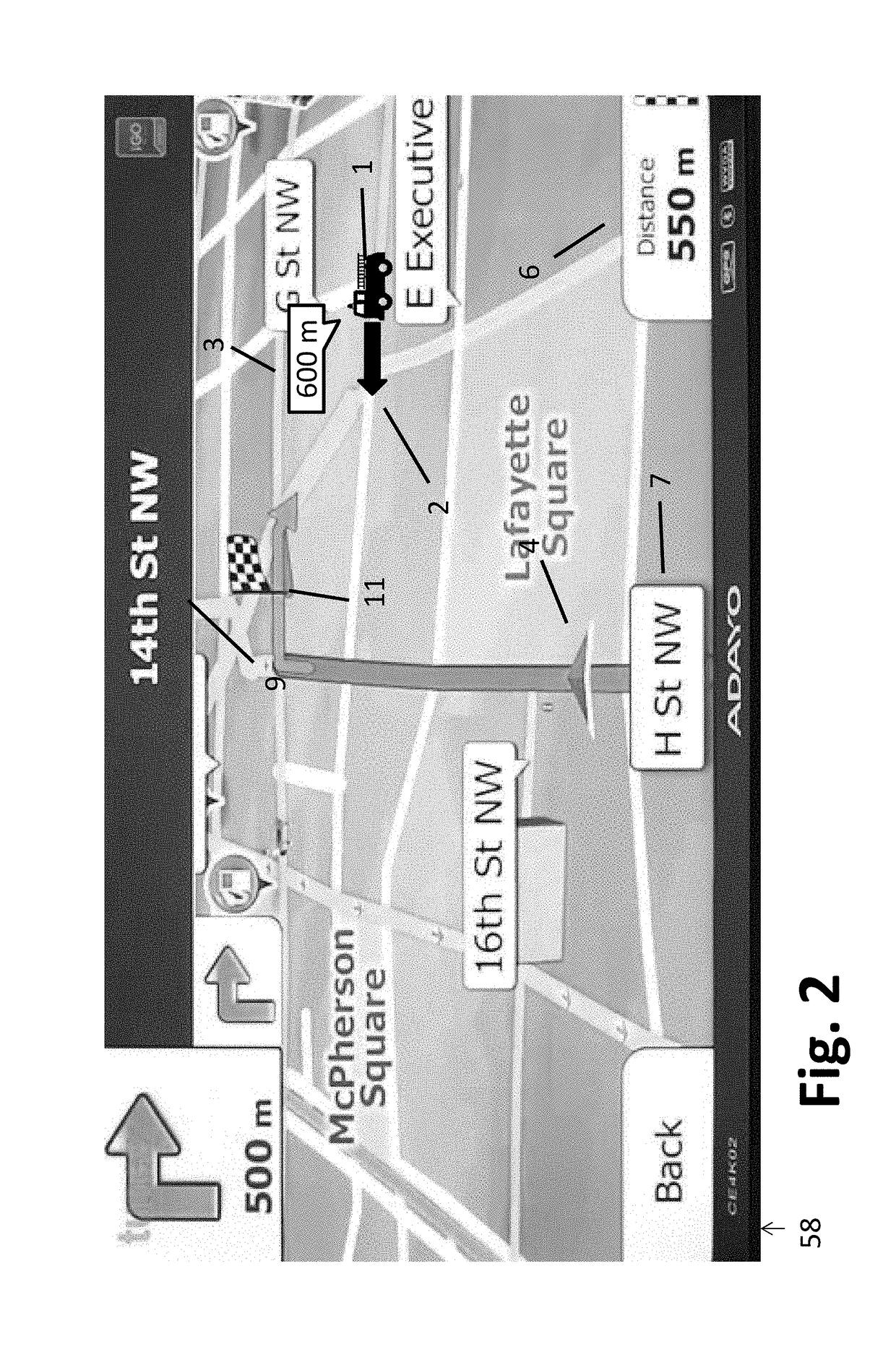
[0018]An arbitrary vehicle 59 employs a Dual Location Receiving and Display System (DLRDS) 61. The DLRDS 61 is comprise...


PUM


Abstract

A system for simultaneously displaying the locations of all nearby emergency vehicles onto the same moving map as the current location of another vehicle is described. Each emergency vehicle receives location data from a GPS receiver and broadcasts the location data using a Bluetooth or other transmitter. Other vehicles receive location data corresponding to their own locations using their own GPS receivers and each displays their own location onto their own moving map display in the usual manner. Additionally, the other vehicles also have Bluetooth or other receivers which receive the local broadcasts containing emergency vehicle locations and display the locations of all emergency vehicles simultaneously with their own location. The operator of the vehicle benefits by knowing the relative locations of the emergency vehicles when they cannot be seen. Some emergency vehicle operators may optionally choose to not broadcast their location data under certain circumstances.

Description

CROSS-REFERENCE TO RELATED APPLICATIONS[0001]Not ApplicableSTATEMENT REGARDING FEDERALLY SPONSORED RESEARCH OR DEVELOPMENT[0002]Not ApplicableREFERENCE TO SEQUENCE LISTING, A TABLE, OR A COMPUTER PROGRAM LISTING COMPACT DISK APPENDIX[0003]Not ApplicableBACKGROUND OF THE INVENTION[0004]The present invention relates to displaying the location of nearby emergency vehicles on GPS map displays in vehicles to improve the situational awareness of drivers.[0005]Drivers of vehicles often hear emergency vehicles but cannot determine their locations in relation to their own vehicle. Therefore drivers cannot immediately determine the best course of action for avoiding the path of approaching emergency vehicles. This can create a delay or safety hazard for both vehicles and for drivers and passengers of nearby vehicles. Resulting confusion and uncertainty also leads to less efficient traffic flow when emergency vehicles are heard by a driver but not yet seen by the driver.[0006]Most drivers alre...

Claims


Application Information

Patent Timeline
Patent Type & Authority Applications(United States)
IPC IPC(8): G08G1/137H04W4/04G01C21/36H04W4/00H04W4/80H04W4/029H04W4/46
CPCG08G1/137H04W4/008G01S19/13G01C21/3667G01C21/3626H04W4/046G08G1/0965G08G1/20G01S19/14G01S19/17G01S5/0072G01C21/3697H04W4/80H04W4/026H04W4/46H04W4/029
Inventor BRETON, MAXWELL JOSEPH
Owner BRETON MAXWELL JOSEPH
Why Eureka
Try Eureka