A method and system for automatically detecting and mapping points-of-interest and real-time navigation using the same

a technology of automatic mapping and real-time navigation, applied in the field of parking systems, can solve the problems of not being able to assign real-world coordinates to parking spaces, not realizing the problem of automatically mapping points, and limited to known parking spaces, so as to reduce the time it takes

Inactive Publication Date: 2018-10-18
PARKAM ISRAEL
View PDF14 Cites 51 Cited by
  • Summary
  • Abstract
  • Description
  • Claims
  • Application Information

AI Technical Summary

Benefits of technology

[0019]According to an embodiment of the invention, the method further comprises detecting crowded areas by using computer vision for understanding the captured images by analyzing data from the real world in order to produce real-time information that represents the level of crowdedness as appear in said captured images, and accordingly to provide data suitable to navigate a user, in real-time, away from those crowded areas to a parking space via a less crowded travelling route, in order to decrease the time it takes for the user to arrive at a destination parking space or to avoid undesired crowded areas.
[0020]According to an embodiment of the invention, the method further comprises providing an independent navigation system for detecting a vacant parking space in an underground / indoor parking lot and accordingly providing navigation data to said vacant parking space, by using processing of visual data provided by images captured with a plurality of cameras deployed in said parking lot, thereby eliminating the need to use traditional GPS-based navigation. According to an embodiment of the invention, the processing of visual data includes optical flow techniques to provide navigation data to the vacant parking space in the underground / indoor parking lot. The optical flow technique may utilize pattern of apparent motion of vehicles in a visual scene caused by the relative motion between a camera and the scene. According to another embodiment, the processing of visual data includes detecting and tracking the license plate of each vehicle that drives through said underground / indoor parking lot.
[0021]According to an embodiment of the invention, the method further comprises detecting Point-of-Interest (POI) located near the mapped parking spaces, and assigning real-world coordinates to said POI for mapping said POI, thereby enabling a navigation service to navigate a user directly to an available parking space that is located as close as currently possible to a desired POI. For example, the POI can be a specific location that someone may find useful or interesting, including a place of business or service such as point-of-sale, stores, shops, service providers, restaurants, theaters, hotels, campsites, and the like.

Problems solved by technology

In the prior-art, there is no real solution to the problem of automatically mapping points-of-interest such as parking space, shops located at a given shopping area, an entrance to a parking lot, etc., at almost any given location (e.g., navigation capabilities within a parking lot).
However, such method is limited to known parking spaces at a given garage and it lacks the ability to assign real-world coordinates to such parking spaces.
Moreover, such method lacks the ability to autonomously detect and map parking spaces or POI, neither in real-time or off-line.
Moreover, such solutions lack the ability to provide real-time navigation to a parking space that has the highest probability to remain free on arrival of the user, not to mention taking into consideration that the parking space should be as close as possible to a desired POI.

Method used


Image

  • A method and system for automatically detecting and mapping points-of-interest and real-time navigation using the same
  • A method and system for automatically detecting and mapping points-of-interest and real-time navigation using the same
  • A method and system for automatically detecting and mapping points-of-interest and real-time navigation using the same

Examples


Embodiment Construction

[0044]Reference will now be made to several embodiments of the present invention, examples of which are illustrated in the accompanying figures. Wherever practicable similar or like reference numbers may be used in the figures and may indicate similar or like functionality. The figures depict embodiments of the present invention for purposes of illustration only. One skilled in the art will readily recognize from the following description that alternative embodiments of the structures and methods illustrated herein may be employed without departing from the principles of the invention described herein.

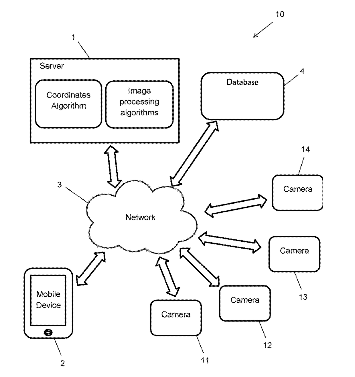
[0045]The present invention provides a system that automatically detects and maps points-of-interest (POI) such as parking spaces, and accordingly locates and directs drivers to available parking spaces as close as possible to desired POI and locations, including specific shop at a shopping center, airports, stadiums, hotels, parking lots, underground parking garages, inner-city parkin...


PUM


Abstract

The present invention relates to a system and method for automatically detecting and mapping points-of-interest (POI) such as parking spaces, and accordingly locating and directing drivers to available parking spaces as close as possible to desired POI and locations. The system is completely autonomous and independent and it uses a Parking Space Detection module that employs machine learning and computer vision techniques for learning the surface of the parking area, the unoccupied life span of a parking space, the occupancy life span of the parking space, detection of suspicious vehicles in terms of parking searcher to independently predict in which available parking space they may parked, and accordingly to navigate in real-time a user to a parking space that has the highest probability to remain free on arrival of that user.

Description

FIELD OF THE INVENTION[0001]The present invention relates to the field of parking systems. More particularly, the invention relates to a method and system of real-time detecting and mapping of points-of-interest (POI) such as parking spaces and nearby shops based on data captured by visual means such as cameras, and implementing such detections with real-time navigation services, in particular providing innovative navigation capabilities within a parking lot or other parking facilities. Moreover, the present invention provides an intelligent computer vision solution that enables to navigate a user in real-time to a parking space that has the highest probability to remain free on arrival and that is close as possible to a desired POI, by independently and autonomously learning the availability life span of the parking spaces.BACKGROUND OF THE INVENTION[0002]In the prior-art, there is no real solution to the problem of automatically mapping points-of-interest such as parking space, sh...

Claims


Application Information

Patent Timeline
Patent Type & Authority Applications(United States)
IPC IPC(8): G08G1/14G06K9/00G06T7/80G06K9/46G06T7/60G01C21/36G05D1/02
CPCG08G1/148G06K9/00798G06T7/80G06K9/4604G06K9/00812G06K9/00778G06T7/60G01C21/3685G01C21/3682G05D1/0212G08G1/141G08G1/144G06T2207/30264G06T2207/20081G06T2207/20076G06K2209/23G06K2209/15G05D2201/0213G08G1/096725G08G1/096741G08G1/096775G08G1/096816G08G1/096838G08G1/096861G08G1/096866G08G1/096883G08G1/0969G08G1/147G08G1/0129G06V20/52G06V20/53G06V20/586G06V20/588G06V20/625G06V2201/08
Inventor NAAMANI, ASAFATTAR, ORI
Owner PARKAM ISRAEL
Why Eureka
Try Eureka