System of vehicles equipped with imaging equipment for high-definition near real-time map generation

a technology of imaging equipment and vehicles, applied in the field of vehicles equipped with imaging equipment for high-definition near real-time map generation, can solve the problems of system like view, high cost, and ineffective prior methods for capturing street level intelligence at city scal

Pending Publication Date: 2018-12-06
WOVEN BY TOYOTA U S INC
View PDF10 Cites 18 Cited by
  • Summary
  • Abstract
  • Description
  • Claims
  • Application Information

AI Technical Summary

Problems solved by technology

Prior methods for capturing street level intelligence at city scale are either expensive or ineffective.
Systems like Google Street View involve expensive equipment mounted on modified vehicles, which are driven for the express purpose of collecting data for creating maps and a visual database.
Solutions that use volunteers to “crowd source” the data never reach useful scale.
In both cases, the data collected becomes stale quickly.

Method used


Image

  • System of vehicles equipped with imaging equipment for high-definition near real-time map generation
  • System of vehicles equipped with imaging equipment for high-definition near real-time map generation
  • System of vehicles equipped with imaging equipment for high-definition near real-time map generation

Examples


Embodiment Construction

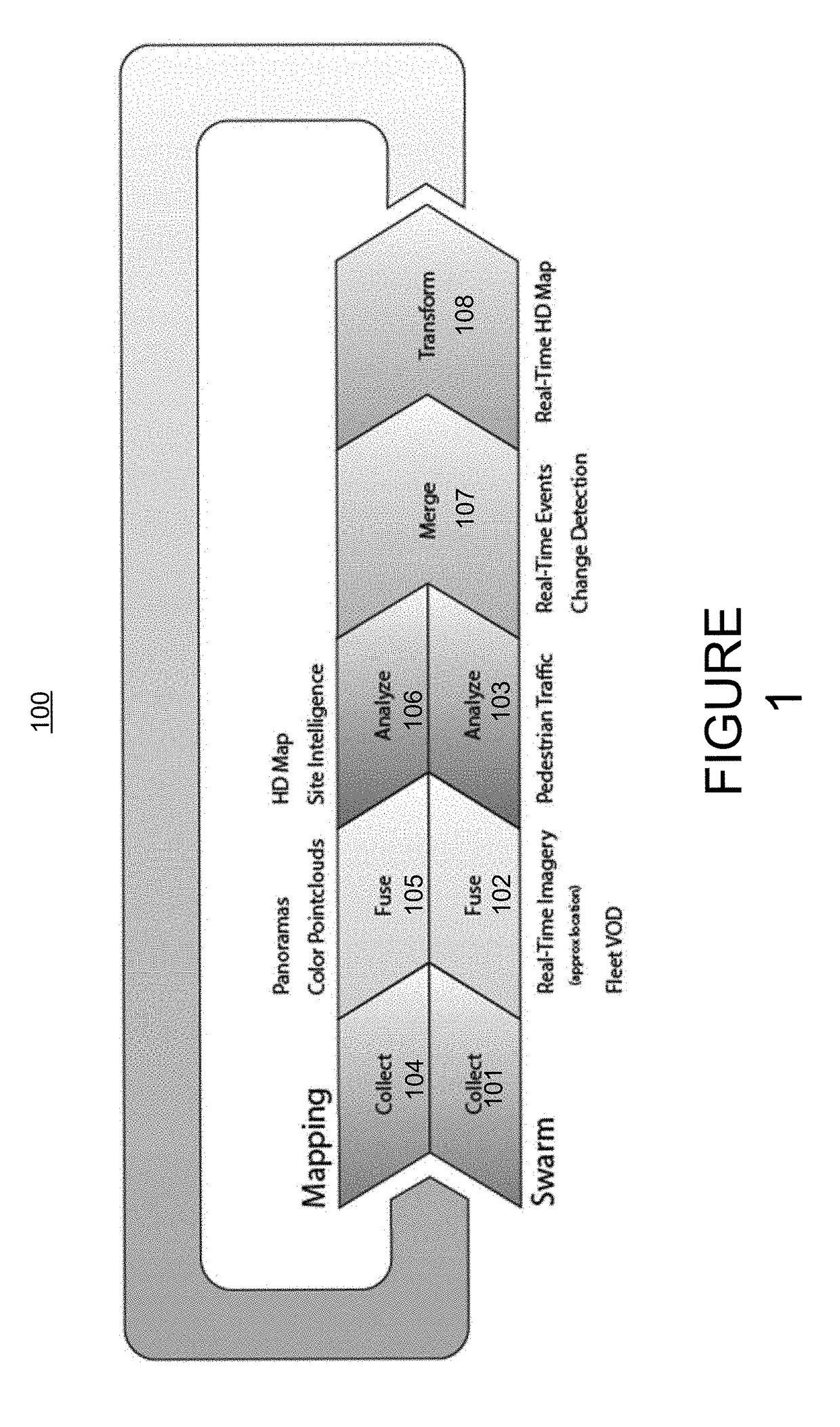
[0025]Described herein, in certain embodiments, are street level intelligence platforms comprising: at least one mapper vehicle, each mapper vehicle comprising an active data capture system comprising a location determination device, a LiDAR device, and at least one imaging device configured to actively capture data pertaining to an environment surrounding the mapper vehicle within a territory; a fleet of swarm vehicles, each swarm vehicle comprising a passive data capture system comprising a location determination device and a plurality of imaging devices configured to passively capture images of an environment surrounding the swarm vehicle within the territory; and a computing system comprising at least one processor and instructions that when executed by the at least one processor cause the at least one processor to create a street level intelligence application comprising: a data processing pipeline configured to: receive data from the active data capture system, combine data fr...


PUM


Abstract

Described are street level intelligence platforms, systems, and methods that can include a fleet of swarm vehicles having imaging devices. Images captured by the imaging devices can be used to produce and / or be integrated into maps of the area to produce high-definition maps in near real-time. Such maps may provide enhanced street level intelligence useful for fleet management, navigation, traffic monitoring, and / or so forth.

Description

CROSS REFERENCE TO RELATED APPLICATIONS[0001]This application is a non-provisional of, and claims the benefit of priority of U.S. Provisional Patent Application No. 62 / 513,056, filed May 31, 2017, entitled “Near Real-Time Street Level Intelligence Platform,” the disclosure of each of which is hereby incorporated by reference in its entiretyBACKGROUND OF THE INVENTION[0002]Street level intelligence has applications in a wide variety of fields including autonomous driving, architecture, construction, engineering, real estate, advertising, city planning, research and others. A fleet of vehicles equipped with imaging equipment can produce and / or supplement a map with high-definition and / or near-real time data to provide enhanced street level intelligence. In general, the street level intelligence may comprise telematics systems on which commercial fleet managers may rely to keep track of vehicles and drivers when they are out in the field. Some fleets may incorporate cameras to provide ...

Claims


Application Information

Patent Timeline
Patent Type & Authority Applications(United States)
IPC IPC(8): G06K9/00G01C21/32G06T7/11G01S17/89G01S17/86
CPCG06K9/00805G01C21/32G06T7/11G06K9/00825G01S17/89G06T2207/30236G01S17/42G01S17/88B60R1/00B60R2300/207B60R2300/301B60R2300/302B60R2300/406B60R2300/50G08G1/0112G08G1/0129G08G1/0133G08G1/0141G08G1/20G01S17/86G06V20/58G06V10/17G01C21/3841B60W60/001B60W40/02B60W50/14B60R11/04B60W2050/146B60W2420/42B60W2050/009B60W2555/60B60W2420/52B60W2556/50B60W2050/0005B60R1/20G06V20/584B60W2554/4029G01C21/3885G01C21/3893H04W4/44
Inventor GUPTA, RODAY, JUSTINNICHOLL, CHASEHENSTELL, MAXSTAMOS, IOANNISBOYLE, DAVIDSORRELGREEN, ETHANDINH, QUYNH
Owner WOVEN BY TOYOTA U S INC
Why Eureka
Try Eureka