Mapping chemostratigraphic signatures of a reservoir with rock physics and seismic inversion

a reservoir and seismic inversion technology, applied in seismology for waterlogging, well accessories, boreholes/well accessories, etc., can solve the problems of limiting the direct knowledge of rock facies and permeability at reservoir locations away from well boreholes, and limiting the direct knowledge of rock facies and permeability at reservoir locations

Active Publication Date: 2019-06-13
SAUDI ARABIAN OIL CO
View PDF0 Cites 9 Cited by
  • Summary
  • Abstract
  • Description
  • Claims
  • Application Information

AI Technical Summary

Benefits of technology

[0007]Briefly, the present invention provides a new and improved method of drilling a well in a subsurface geological structure to a location in a subsurface hydrocarbon reservoir indicated by rock physics modeling of chemostratigraphic signatures of formations of the subsurface hydrocarbon reservoir over its three-dimensional extent to indicate reservoir properties. Wireline well logging measures are obtained from wells in the reservoir representing properties of the subsurface reservoir for processing in a data processing system. The wireline well logging measures are analyzed to indicate properties of the reservoir as functions of well depth in the reservoir. A chemostratigraphic analysis of core and cutting samples from the wells in the reservoir is performed to indicate relative presence of chemical elements as functions of well depth in the reservoir. Indications of attributes of interest in the reservoir formations are formed with attribute templates. A seismic inversion of formation attributes is then performed to indicate chemostratigraphic properties for reservoir regions located between wells in the reservoir. A rock physics model map is then formed of chemostratigraphic properties of formations of the subsurface hydrocarbon reservoir over its three-dimensional extent to indicate reservoir regions located between wells in the reservoir as prospects for drilling of a well. A well is then drilled in the subsurface geological structure to a location in a subsurface hydrocarbon reservoir indicated by the mapped rock physics model.

Problems solved by technology

Further, conditions nearest the borehole can have significant effects on the measures of properties and facies of the rock.
Direct knowledge of rock facies and permeability at reservoir locations away from well boreholes can only be obtained directly by further and costly wells drilled at such locations.

Method used


Image

  • Mapping chemostratigraphic signatures of a reservoir with rock physics and seismic inversion
  • Mapping chemostratigraphic signatures of a reservoir with rock physics and seismic inversion
  • Mapping chemostratigraphic signatures of a reservoir with rock physics and seismic inversion

Examples


Embodiment Construction

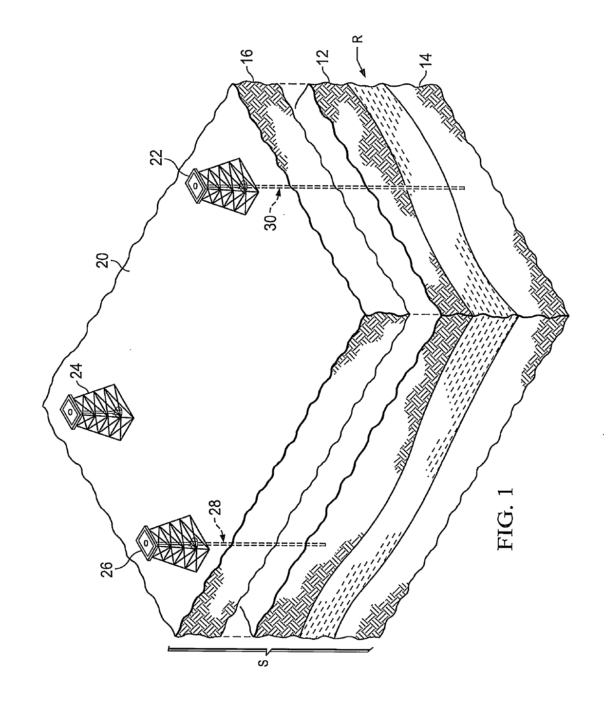
[0020]In the drawings, FIG. 1 is an isometric view in schematic form of a subsurface geological structure S or formations in the earth at a location where a subsurface hydrocarbon reservoir R in the form of a hydrocarbon producing formation rock layer is present. As shown in FIG. 1, the hydrocarbon producing formation rock layer is present beneath several other formation rock layers, such as indicated at 12 and 16 below the earth surface 20, and above a rock layer 14. As indicated at 22, 24 and 26, exploratory or production wells have been drilled to penetrate the earth formations through wellbores as indicated at 28 and 30.

[0021]As has been set forth, knowledge of facies and properties of formation rock in situ beneath the surface of the earth is available from core samples extracted from walls of the formations adjacent to well boreholes. Knowledge of facies and properties of formation rock is also available from measurements obtained with wireline well logging tools lowered throu...


PUM


Abstract

Mapping is performed of chemostratigraphic signatures of hydrocarbon reservoirs in three dimensions. Up-scaled chemostratigraphic data from well cuttings and well cores are tied with high-resolution elastic wireline data at well locations in the reservoir. The wireline data is used to determine suitable seismic attributes for mapping the desired chemostratigraphic property, and are obtained by performing pre- and/or post-stack inversions. A multi-attribute template, derived from the well data, is developed to characterize the reservoir in terms of its chemostratigraphic properties. The seismic data is then inverted to map the chemostratigraphic signatures of reservoir in three dimensions.

Description

BACKGROUND OF THE INVENTION1. Field of the Invention[0001]The present invention relates to rock physics modeling of subsurface formations, and more particularly to mapping chemostratigraphic signatures of the reservoir over its three-dimensional extent to indicate reservoir properties indicating the presence of hydrocarbons.2. Description of the Related Art[0002]In reservoir planning and engineering, an understanding of the nature and characteristics of subsurface rock of the formations of the reservoir, and the properties of such rock are important for hydrocarbon exploration and development. The nature and characteristics of the rock are known as its facies. The facies of a subsurface rock indicates its origin, and permit analysts to differentiate it from other adjacent rock formations.[0003]Among the properties of a subsurface rock is its permeability. Permeability is a measure indicative of the relative ease or difficulty of fluid flow through a rock at a given pressure. Higher ...

Claims


Application Information

Patent Timeline
Patent Type & Authority Applications(United States)
IPC IPC(8): G01V1/50E21B41/00E21B49/00E21B49/02
CPCG01V1/50E21B41/0092E21B49/00E21B49/005E21B49/02G01V2210/6246G01V2210/6222G01V2210/6224G01V1/306G01V1/345G01V11/00G01V2210/6242G01V2210/6169E21B41/00
Inventor LUBBE, RUDICRAIGIE, NEIL WILLIAMMICHAEL, NIKOLAOS ANDREAS
Owner SAUDI ARABIAN OIL CO
Why Eureka
Try Eureka