Systems And Methods For Determining A Location Of An Electronic Device Using Bilateration

a technology of electronic devices and location information, applied in the direction of location information based services, transmission monitoring, vehicle components, etc., can solve the problems of difficult to receive an accurate gps signal, slow or impossible to obtain gps location information, and degrade gps signals, so as to achieve consistent and precise locations and accurate location determinations

Active Publication Date: 2019-12-05
KENMAR CORP
View PDF0 Cites 4 Cited by
  • Summary
  • Abstract
  • Description
  • Claims
  • Application Information

AI Technical Summary

Benefits of technology

[0009]The systems and methods described herein address how to mitigate various problems associated with local-area-network-assisted location determination (e.g., Wi-Fi assisted location determination) and produce consistently accurate and precise locations. The subject invention can produce precise location determinations for the electronic device from 10 times to 100 times a second. Further, the location determinations performed according to the subject invention are able to be accurate within a few feet, even in environments such as urban canyons. Moreover, the subject invention provides accurate location determinations even if there are only two signals available.

Problems solved by technology

However, GPS systems require line-of-sight signals from GPS satellites, so in cities, the presence of tall buildings can make it difficult to receive an accurate GPS signal.
Reflections can also degrade GPS signals by causing multipath interference.
As a result, GPS location information can be slow or impossible to obtain.
Further, in situations such as those involving roads with branches, GPS systems in vehicles can have difficulties in accurately determining which branch of the road a vehicle is located on.
As a result, commercially available GPS solutions may not provide sufficient resolution to determine when a vehicle has exited a freeway.
In large cities such as San Francisco, New York, and Chicago, there are many locations in which GPS signals do not operate or may not provide sufficiently consistent location data for navigation.
For example, if a user takes the subway around the city, the current GPS systems may not be able to determine any locations within the tunnels, and this may lead a user to exit the train at the wrong train station.
However, such known systems require at three signals and can consume additional time if many signals are present.
Further, the known methodologies do not provide sufficiently consistent and accurate location data for the electronic device.

Method used


Image

  • Systems And Methods For Determining A Location Of An Electronic Device Using Bilateration
  • Systems And Methods For Determining A Location Of An Electronic Device Using Bilateration
  • Systems And Methods For Determining A Location Of An Electronic Device Using Bilateration

Examples


Embodiment Construction

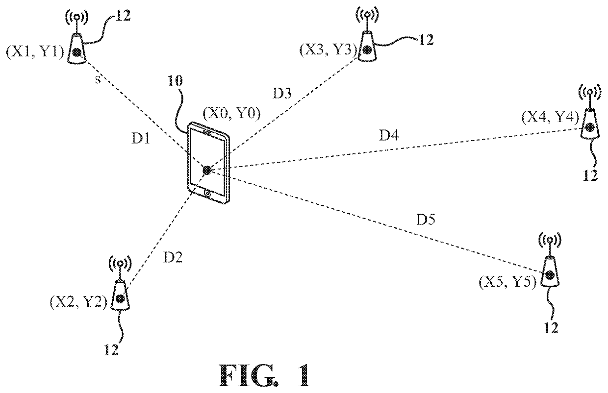
[0022]Referring to the Figures, wherein like numerals indicate like or corresponding parts or steps throughout the several views, FIG. 1 depicts an electronic device, shown generally at 10, spaced from transmitting devices, shown generally at 12, and a location of the electronic device 10 is determined using bilateration. The method is able to determine the location of the electronic device 10 via geolocation identification in mobile Heterogeneous Networks (HetNet) environments. In some embodiments, the electronic device 10 may have connectivity to a transmitting device 12. Here, “connectivity” does not necessarily require that a wireless session be initiated between the transmitting device 12 and the electronic device 10; instead, it may be sufficient that data (e.g., IP / WLAN packets) can be successfully transmitted from the electronic device 10 to the transmitting device 12, or from the transmitting device 12 to the electronic device 10. For example, if the electronic device 10 is...


PUM


Abstract

A method of determining a location, using bilateration, of an electronic device that is spaced from transmitting devices is disclosed. The electronic device receives first and second signals of the same or different signal type from first and second transmitting devices, respectively, with a tunable antenna. The electronic device determines a signal quality of each signal based on: 1) a received signal strength indicator (RSSI) or a received signal power and a received signal gain, and 2) signal propagation characteristics specific for the transmitting devices. The signals with the two highest signal qualities are used for location determination and the antenna is tuned for each of the signal types received. The distance from the transmitting devices can be determined based on one or more of: a received signal power and signal gain for both signals, a transmitted power and signal gain of both signals, or location information associated with the transmitting devices. The method determines two points of intersection based on the distance, determine which intersection is reliable, generates new coordinates for the electronic device.

Description

BACKGROUND1. Field of the Invention[0001]The subject invention relates to a method for determining a location of an electronic device using bilateration.2. Description of Related Art[0002]As electronic devices, such as computers and cell phones, have become more prevalent, there is a growing desire to determine the location for such devices for a variety of applications. One of the most prevalent consumer applications has been in travel. The electronic device may reside in an unknown location, and it may be desirable to determine the location of the device. One common approach is to use a Global Positioning System (“GPS”) to determine location. GPS systems incorporate navigation systems which help the user find their desired destinations. Many of the systems provide navigation with visual and audio cues that aid the user in navigating through streets and highways which may be unfamiliar to the user.[0003]However, GPS systems require line-of-sight signals from GPS satellites, so in c...

Claims


Application Information

Patent Timeline
Patent Type & Authority Applications(United States)
IPC IPC(8): H04W4/029H04W4/40H04W4/80H04B17/318H04W4/02
CPCH04W4/40H04B17/318H04W4/80H04W4/029H04W4/027H04W4/46
Inventor FAIRBANKS, NEALNADER, FREDERICK R.RUSK, COLLIN M.
Owner KENMAR CORP
Why Eureka
Try Eureka