Method and system for geolocating a terminal of a wireless communication system

Pending Publication Date: 2021-08-26
SIGFOX
View PDF0 Cites 0 Cited by
  • Summary
  • Abstract
  • Description
  • Claims
  • Application Information

AI Technical Summary

Benefits of technology

[0011]The objective of the present invention is to remedy all or some of the drawbacks of the prior art, in particular those disclosed above, by proposing a solution that makes it possible to determine the

Problems solved by technology

Such a solution does however have the drawback that transmitting the information on the geographical position to the access network may be expensive in terms of data size (number of bits used for encoding this information).
These methods for estimating the geographical position of a terminal by

Method used


Image

  • Method and system for geolocating a terminal of a wireless communication system
  • Method and system for geolocating a terminal of a wireless communication system
  • Method and system for geolocating a terminal of a wireless communication system

Examples


Example

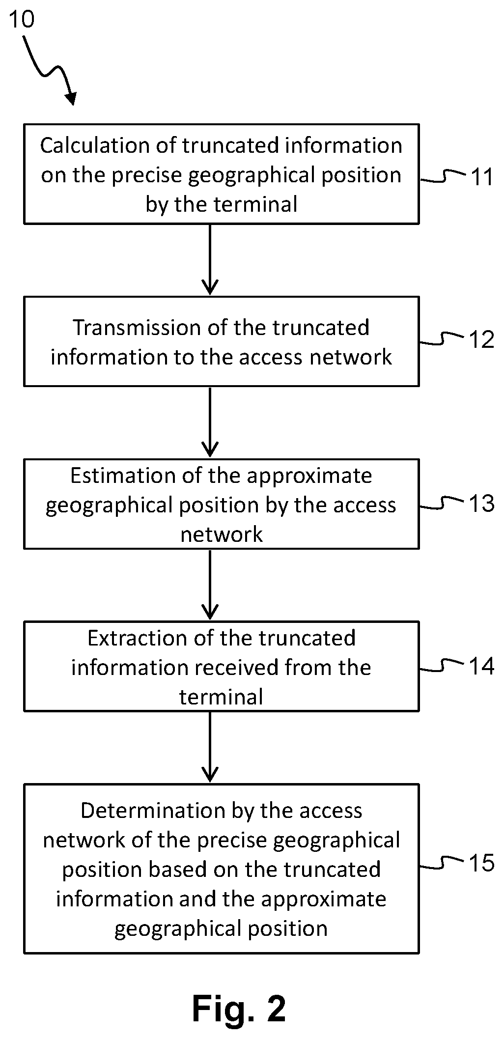
[0078]In a first embodiment, the geographical position of the terminal 70 comprises a latitude and a longitude as geographical coordinates.

[0079]By way of in no way limitative example, the latitude and the longitude of a geographical position are encoded in 24 bits (N=M=24). The most significant bit corresponds to a sign bit while the 23 least significant bits correspond to data bits encoding values lying between 0 and 223−1=8,388,607.

[0080]In order to pass to a standard latitude value lying in an interval [−90°; 90°], it should be noted that the 23 data bits make it possible to obtain a granularity of approximately 1.07×10⁻⁵ degrees of arc per unit. Knowing that the distance on the surface of the terrestrial globe corresponding to one degree of arc is approximately 110 km, the use of 24 bits for encoding a latitude value makes it possible to define a latitude with a precision of around 1.2 meters on the surface of the terrestrial globe.

[0081]Likewise, in order to pass to a standard...

Example

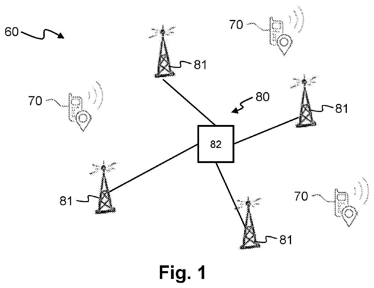
[0128]For example, in a second embodiment, the geographical position of the terminal 70 includes a region identifier and a zone identifier. FIG. 5 shows schematically a division of a geographical territory into a grid of various regions R1 to R4 and various zones Z1 to Z9. The territory is first of all divided into various regions R1 to R4 in square form. The various regions R1 to R4 all have the same dimensions. Each region is next divided into various zones Z1 to Z9. They are also in square form and all have identical dimensions. As illustrated in FIG. 5, the various zones Z1 to Z4 are numbered in an identical scheme in each region R1 to R4. In the example shown in FIG. 5, there are only four regions R1 to R4 and each region R1 to R4 includes nine zones Z1 to Z9. It will of course be possible to envisage using a larger number of regions and / or a larger number of zones and / or different forms of zone and / or region.

[0129]In this second embodiment, the terminal 70 has a positioning de...


PUM


Abstract

A method for geolocating a terminal of a wireless communication system. The terminal includes a positioning device for obtaining a precise geographical position of the terminal. An access network of the communication system estimates an approximate geographical position of the terminal. In order to limit the size of the messages exchanged between the terminal and the access network, only a truncated part of the information about the precise geographical position of the terminal is transmitted by the terminal to the access network. The access network determines the precise geographical position of the terminal by combining the truncated information received from the terminal with the approximate geographical position estimated by the access network.

Description

TECHNICAL FIELD[0001]The present invention relates to a method and a system for geolocating a terminal of a wireless communication system. The invention is particularly well suited to the context of the Internet of Things in applications requiring geolocation.BACKGROUND OF THE INVENTION[0002]There currently exist numerous solutions for determining the geographical position of a terminal of a wireless communication system.[0003]For example, the terminal may incorporate a positioning system enabling it to determine the geographical position thereof. The terminal may then send a message indicating this geographical position to an access network of the wireless communication system.[0004]Such a solution does however have the drawback that transmitting the information on the geographical position to the access network may be expensive in terms of data size (number of bits used for encoding this information). This is because, in wireless communication systems with a low bit rate and low e...

Claims


Application Information

Patent Timeline
IPC IPC(8): G01S5/00H04W64/00
CPCG01S5/0054H04W64/00G01S5/0036G01S19/42G01S5/018G01S5/0205
Inventor HUBERT, LOÏC
Owner SIGFOX
Why Eureka
Try Eureka