Georeferencing certification method and system for mobile devices

Active Publication Date: 2022-04-28
ETUITUS SRL
View PDF0 Cites 0 Cited by
  • Summary
  • Abstract
  • Description
  • Claims
  • Application Information

AI Technical Summary

Benefits of technology

The invention is a system that allows a user to certify their position using a mobile device with a GNSS sensor. The user's position is determined by a certification server that analyzes data from the GNSS sensor and compares it with data from the server's own GNSS sensors. The server also requests additional information from the user's device to verify the authenticity of the position. The system is designed to provide a secure and accurate means of georeferencing, which can be used in various applications such as navigation and sports equipment.

Problems solved by technology

Currently, the detection of the information is not very reliable from the point of view of security, as it can be easily manipulated on the common mobile devices.
These methods mostly offer mechanisms for identifying possible inconsistencies in the signal detected, which are only present in a signal reproduced artificially, but they cannot always be actuated on devices or are too complex to be implemented on common mobile devices, which are characterised by limited processing power and low availability in terms of memory and autonomy.

Method used


Image

  • Georeferencing certification method and system for mobile devices
  • Georeferencing certification method and system for mobile devices

Examples


Embodiment Construction

[0014]List of drawings

[0015]The invention is now described, by way of example and without limiting the scope of the invention, with reference to the accompanying drawings, in which:

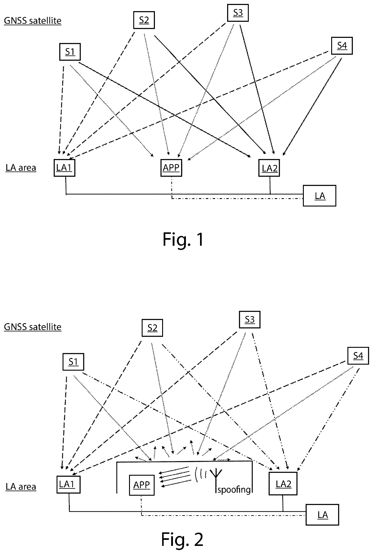
[0016]FIG. 1 shows GNSS signals, the certification server and the mobile device with the client application;

[0017]FIG. 2 shows a SCENARIO 1: spoofing of the GNSS signal with a single antenna simulator in an environment isolated from signals sent from the satellites;

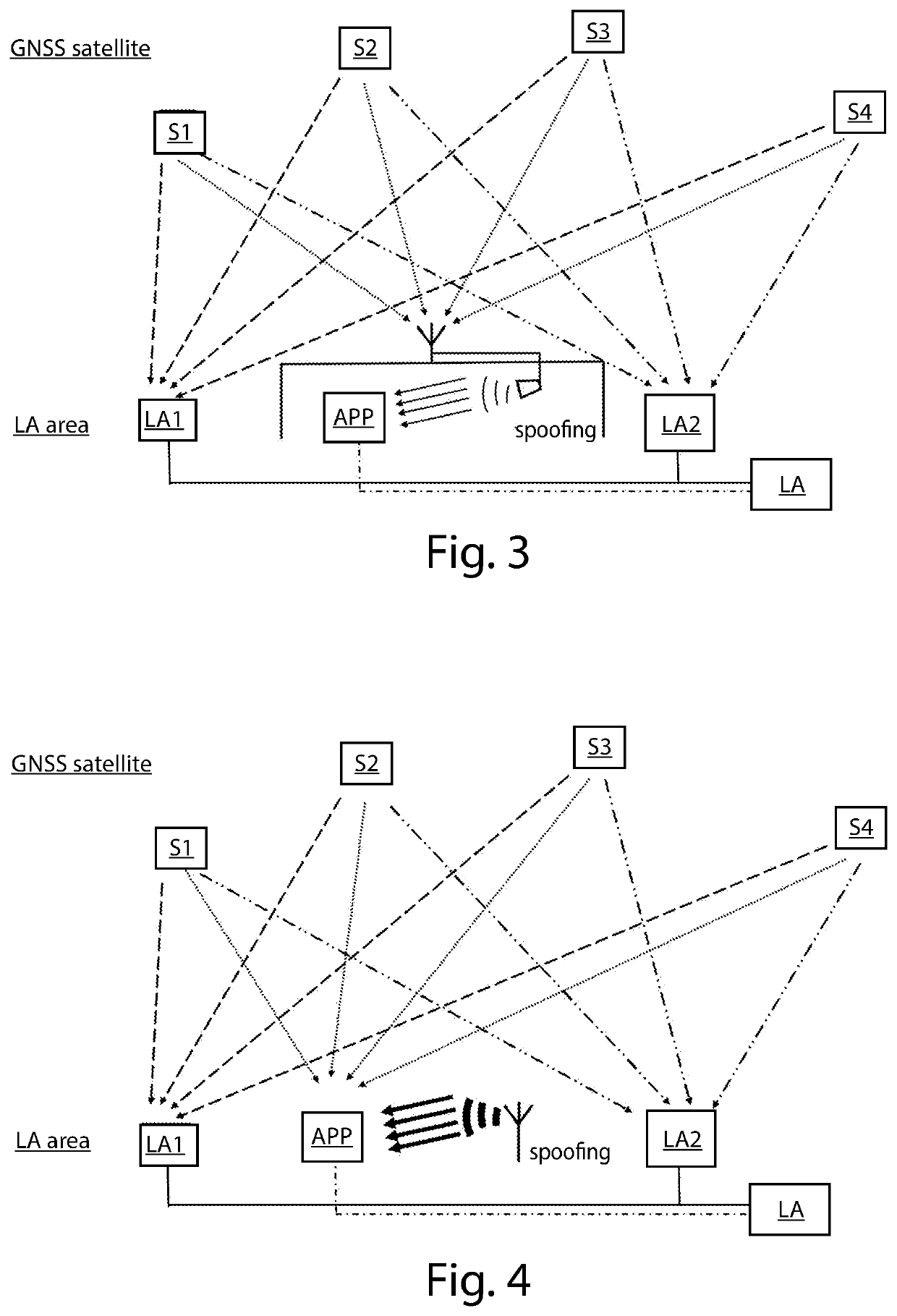
[0018]FIG. 3 shows a SCENARIO 2: spoofing of the GNSS signal with acquisition of the original signals using an antenna and retransmission of signals processed in an environment isolated from signals sent from the satellites; and

[0019]FIG. 4 shows a SCENARIO 3: spoofing of the GNSS signal with a single antenna simulator outdoors configured for generating a signal having a power greater than the power of the GNSS signal.

[0020]It should be noted that elements of different embodiments can be combined together to provide further embodiments without ...


PUM


Abstract

The present invention relates to a georeferencing certification method actuated by means of a central unit with one or more GNSS sensors and one or more mobile devices which request the georeferencing. The mobile device will collect the information monitored by the GNSS sensor installed on the mobile device and send it to the central unit, which will compare the information received with that which it has acquired through its relative GNSS sensors. The result of the comparison will authorise, or not, the unit to issue the georeferencing certification.

Description

[0001]This invention relates to a georeferencing certification method and system for mobile devices.[0002]More specifically, the invention relates to a georeferencing certification method actuated by means of a central unit with one or more GNSS sensors or receivers (Global Navigation Satellite System) and one or more mobile device which require the georeferencing. The mobile device will collect the information monitored by the GNSS sensor installed on the mobile device and send it to the central unit, which will compare the information received with that which it has acquired through its relative GNSS sensors. The result of the comparison will authorise, or not, the central unit to issue the georeferencing certification.Introductory Principles[0003]All satellite navigation systems are based on the same approach: a network of satellites orbiting around Earth which send radio signals for calculating position, speed and time (PVT). The receiving devices, knowing the positions of each ...

Claims


Application Information

Patent Timeline
IPC IPC(8): G01S19/21G01S19/30G01S19/25G01S19/29H04W12/30H04W12/104H04W12/63H04W12/069H04W4/029
CPCG01S19/215G01S19/30G01S19/256G01S19/29H04W4/029H04W12/104H04W12/63H04W12/069H04W12/30H04W12/10H04L63/107H04L63/1466H04W12/12H04W4/02G01S19/03
Inventor CATTANEO, GIUSEPPEFARUOLO, POMPEOMANNETTA, MARCO
Owner ETUITUS SRL
Why Eureka
Try Eureka