Method and apparatus for orienting a map display in a mobile or portable device

a map display and mobile or portable technology, applied in the field of electronic mapping technology, can solve the problems of limiting the orientation tradition, inability to reliably determine the movement of small objects, and inability to accurately calculate the orientation

Inactive Publication Date: 2002-04-02
QUALCOMM INC
View PDF3 Cites 192 Cited by
  • Summary
  • Abstract
  • Description
  • Claims
  • Application Information

AI Technical Summary

Problems solved by technology

However, since the resolution accuracy of the GPS system is limited, a small amount of movement cannot be reliably determined, and thus orientation cannot be accurately calculated.
As mapping technology has become more readily available and more responsive to a user's particular environment, this orientation tradition has become limiting.
While the foregoing reorientation of a map display can be accomplished with GPS based systems, the positioning accuracy limitations of the GPS system causes problems.
Also, when the device motion slows to the point where the movement between successive fixes is less than the resolution of the GPS system, then a degree of uncertainty arises as to what the current orientation, or heading is.

Method used


Image

  • Method and apparatus for orienting a map display in a mobile or portable device
  • Method and apparatus for orienting a map display in a mobile or portable device
  • Method and apparatus for orienting a map display in a mobile or portable device

Examples


Embodiment Construction

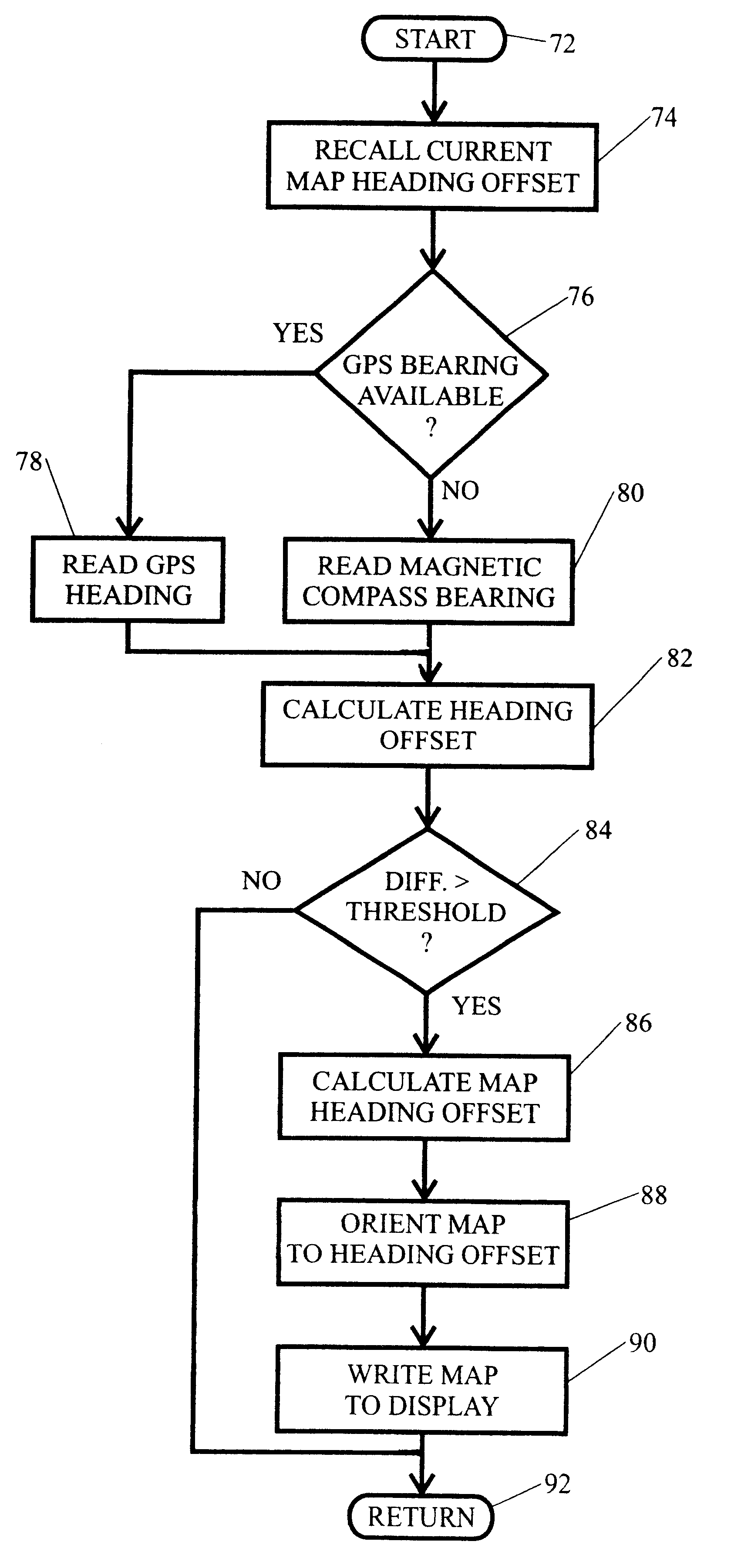
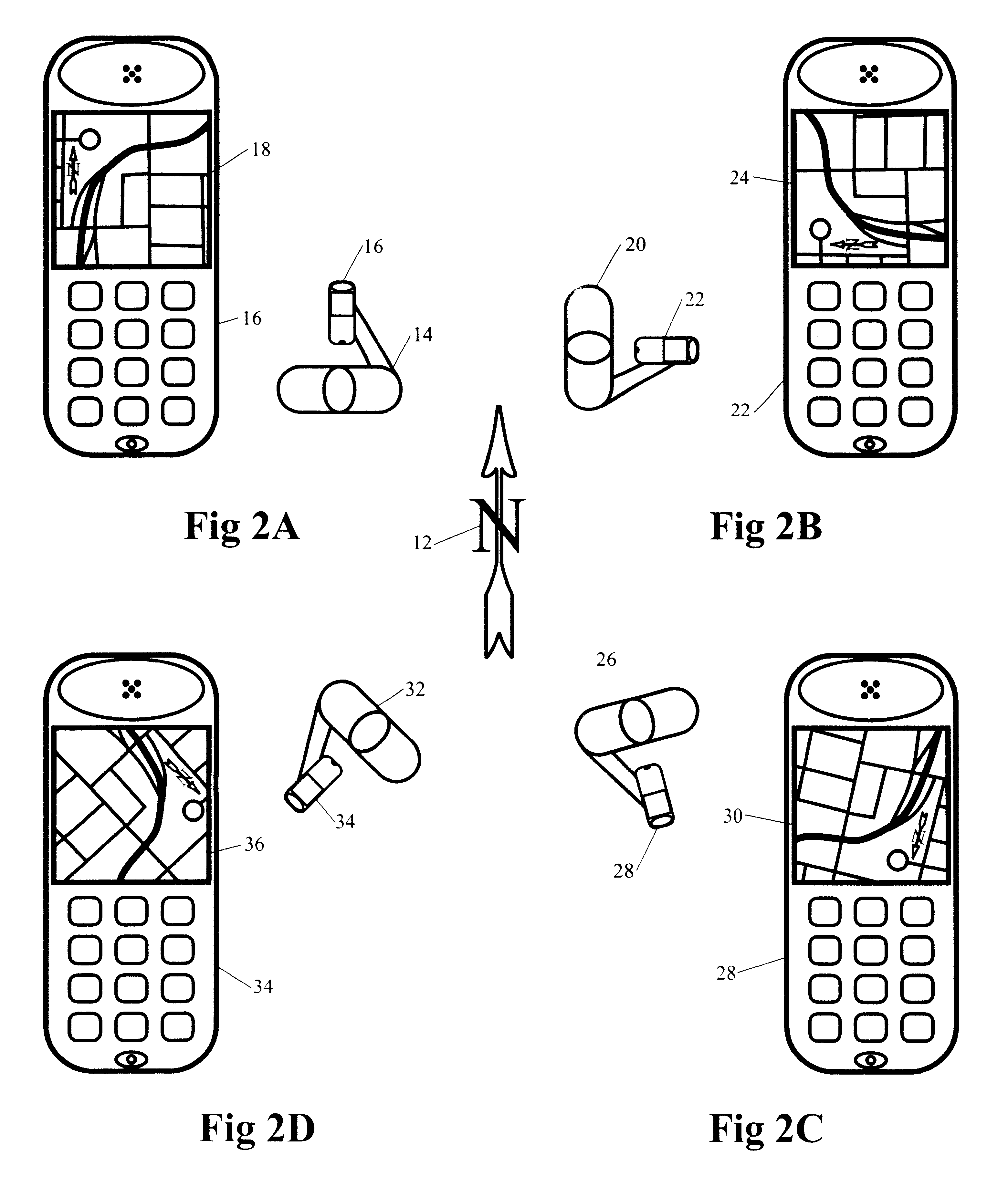
Illustrative embodiments and exemplary applications will now be described with reference to the accompanying drawings to disclose the advantageous teachings of the present invention. While the present invention is described herein with reference to illustrative embodiments for particular applications, it should be understood that the invention is not limited thereto. Those having ordinary skill in the art and access to the teachings provided herein will recognize additional modifications, applications, and embodiments within the scope thereof and additional fields in which the present invention would be of significant utility.

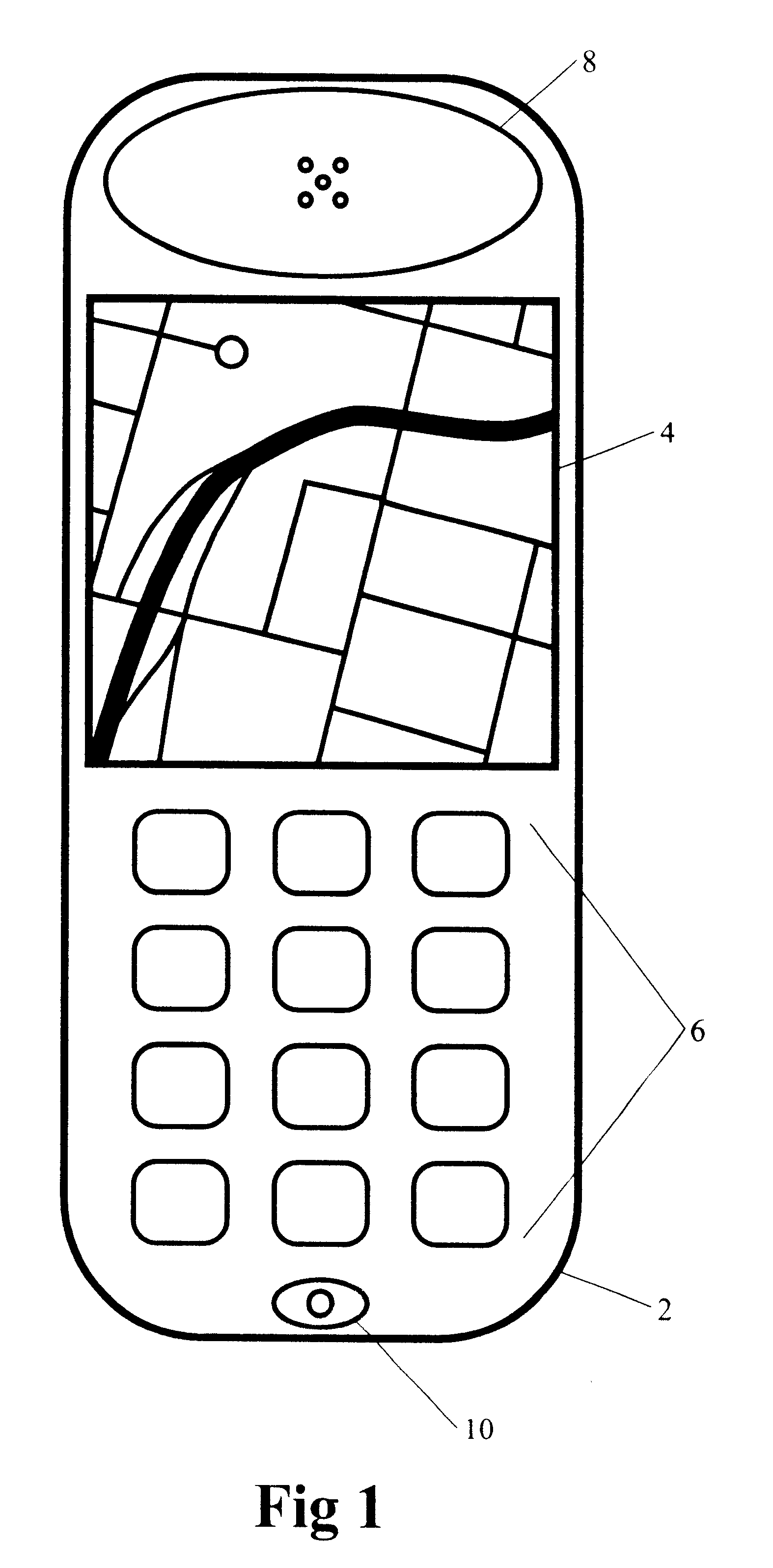
The illustrative embodiments of the present invention are generally implemented within hand-held portable or mobile-vehicular devices that provide map display guidance information. However, it is applicable to any device that is not fixed in position. Such devices may be preprogrammed with map data in a memory, or the map data may be placed into the memory whil...


PUM


Abstract

A method apparatus for orienting a map display in a mobile or portable device. An electronic compass is integrated with a hand-held portable or mobile mapping device and an electronic compass bearing is used to calculate an offset value with respect to the map default orientation. The map is thus reoriented in the display to the direction of the device. In an alternative embodiment, a GPS receiver is also integrated with the device. A heading fix is calculated from two or more GPS position fixes to determine orientation of the device. When a heading fix is unavailable, such as at initial start-up of the device, a compass heading is used in lieu of the GPS heading fix to orient the map on a display.

Description

1. Field of the InventionThe present invention relates to electronic mapping technology. More specifically, the present invention relates to systems and methods for utilizing an electronic compass or a GPS directional fix to orient a map in the display of an electronic device so as to be consistent with the orientation of the device with respect to Earth.2. Description of the Related ArtThe use of computer mapping technology has been growing dramatically in recent years. The widespread availability of accurate electronic maps and the low cost of processing and display technology have been driving forces behind this trend. Maps are available on fixed media, within memory, and over networks, such as the Internet. Mapping software systems with GPS based position determination are now deployed in motor vehicles such that localized maps are readily available to users. An example of this implementation is in rental cars where detailed maps and driving directions are provided to the user i...

Claims


Application Information

Patent Timeline
Patent Type & Authority Patents(United States)
IPC IPC(8): G01C21/20G01C17/28G01C17/00G01S5/14H04M1/72H04M1/725G09B29/00G01C21/00G01S19/48G08G1/0969G09B29/10H04M1/72403
CPCG01C17/28G01C21/20G01S19/53G01S19/49H04M2250/10H04M1/72522H04M1/72403G01S5/017
Inventor JOHNSON, PAUL
Owner QUALCOMM INC
Why Eureka
Try Eureka