Method of collecting road sign information using mobile mapping system

a technology of road sign information and mobile mapping system, which is applied in the field of collecting road sign information using a mobile mapping system, can solve the problems of requiring a lot of time and cost to manufacture hd-maps, and achieve the effects of improving recall and accuracy (accuracy) in recognizing, and improving the accuracy of recognizing road sign information

Active Publication Date: 2021-01-14
MOBILTECH
View PDF0 Cites 4 Cited by
  • Summary
  • Abstract
  • Description
  • Claims
  • Application Information

AI Technical Summary

Benefits of technology

[0014]Particularly, another object of the present invention is to provide a method of collecting road sign information using a mobile mapping system, which can collect correct road marking information in real-time by extracting objects and attributes from successive images on the basis of deep learning and map the road marking information to a high definition map, and remarkably improv...

Problems solved by technology

However, since most of the information like this is manually mapped to a HD-map, t...

Method used


Image

  • Method of collecting road sign information using mobile mapping system
  • Method of collecting road sign information using mobile mapping system
  • Method of collecting road sign information using mobile mapping system

Examples


Embodiment Construction

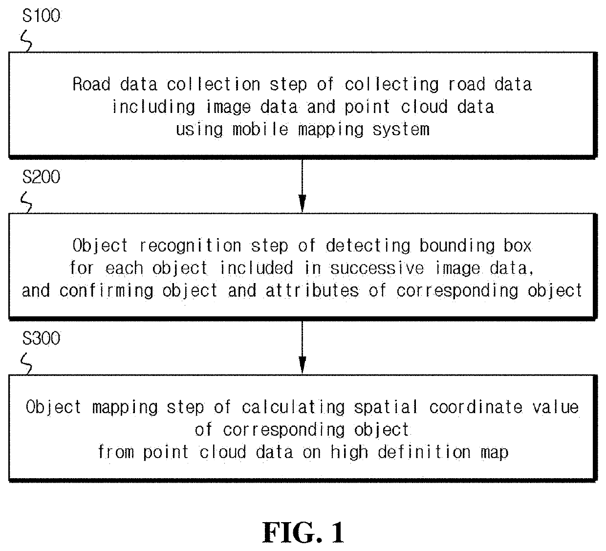
[0033]Examples of a method of collecting road sign information using a mobile mapping system according to the present invention may be diversely applied, and the most preferred embodiment will be described below with reference to the accompanying drawings.

[0034]FIG. 1 is a flowchart illustrating an embodiment of a method of collecting road sign information using a mobile mapping system according to the present invention.

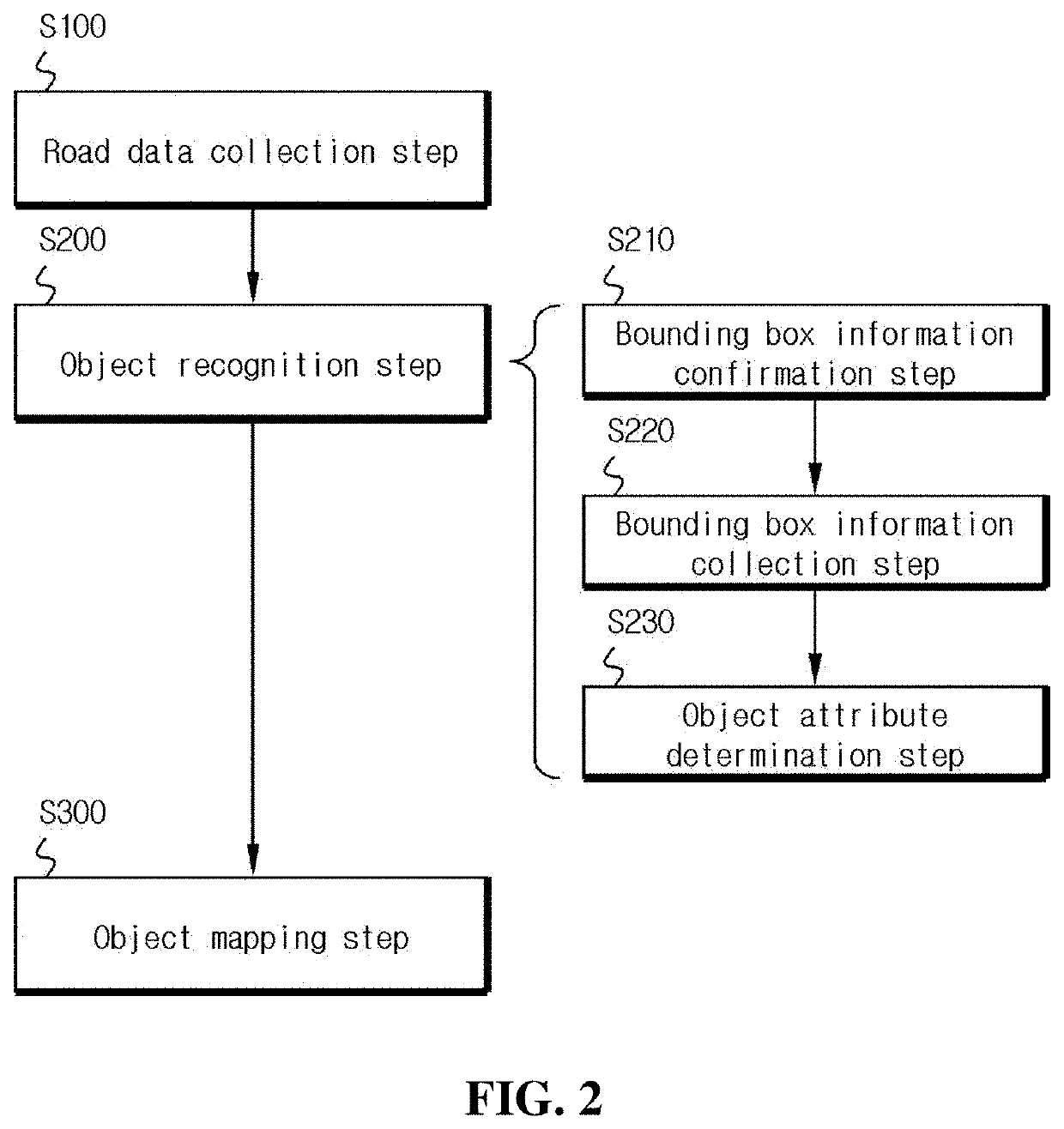
[0035]Referring to FIG. 1, a method of collecting road sign information using a mobile mapping system includes a road data collection step (S100), an object recognition step (S200), and an object mapping step (S300).

[0036]The road data collection step (S100) is a step of collecting road data including image data and point cloud data using a mobile mapping system, which collects three-dimensional information of a driving road in real-time.

[0037]Here, the mobile mapping system is a system for collecting geospatial data including roads and surrounding environments using...


PUM


Abstract

A method of collecting road sign information using a mobile mapping system, which can collect information on the markings on the road in real-time and map the information to a high definition map using the mobile mapping system including a remote sensing device and a navigation device is disclosed. Particularly, the system may collect correct road marking information in real-time by extracting objects and attributes from successive images on the basis of deep learning and map the road marking information to a high definition map, and remarkably improve accuracy of recognizing the road marking information. Accordingly, reliability and competitiveness may be enhanced in the autonomous driving field, the road recognition field, the high definition road map field for autonomous driving, and the fields similar or related thereto.

Description

BACKGROUND OF THE INVENTIONField of the Invention[0001]The present invention relates to a method of collecting road sign information using a mobile mapping system, and more specifically, to a method of collecting road sign information using a mobile mapping system, which can collect information on the markings on the road in real-time and map the information to a high definition map using a mobile mapping system including a remote sensing device and a navigation device.[0002]Particularly, the present invention relates to a method of collecting road sign information using a mobile mapping system, which can collect correct road marking information in real-time by extracting objects and attributes from successive images on the basis of deep learning and map the road marking information to a high definition map, and remarkably improve accuracy of recognizing the road marking information.Background of the Related Art[0003]Unmanned autonomy of vehicles (autonomous vehicle) may largely com...

Claims


Application Information

Patent Timeline
IPC IPC(8): G06K9/00G06K9/32G01C21/36
CPCG06K9/00818G01C21/3602G06K9/325G01C21/3848G01C21/3822G01C21/3811G06V20/582G06V10/255G06T2210/12G06T2207/30256G06V20/56G06V20/62
Inventor KIM, JAESEUNGKIM, JISEONG
Owner MOBILTECH
Why Eureka
Try Eureka