Guiding vehicle in adjacent swaths across terrain via satellite navigation and tilt measurement

a technology of satellite navigation and guiding vehicles, applied in vehicle position/course/altitude control, process and machine control, instruments, etc., can solve problems such as guidance errors, approximation worsening, and inability to determine the position of objects

Inactive Publication Date: 2004-03-09
TRIMBLE NAVIGATION LTD
View PDF6 Cites 104 Cited by
  • Summary
  • Abstract
  • Description
  • Claims
  • Application Information

AI Technical Summary

Benefits of technology

The present invention is directed to a method of guiding a vehicle in adjacent swaths across terrain that may slope. In one embodiment, the method comprises the following steps: (1) determining the tilt of the vehicle with respect to Earth due to a slope of the terrain; (2) determining the position with respect to Earth of a predetermined location that is fixed relative to the vehicle; and (3) using the tilt and position determinations to provide information for guiding the vehicle to prevent gaps and overlaps between adjacent swaths as the slope changes.

Problems solved by technology

However, if the tractor is on an inclined terrain with a variable tilt, which is often the case, the SATPS alone cannot determine the terrain tilt so the POI also cannot be determined.
This results in a guidance error because the POI is approximated by the point of reception (POR), and this approximation worsens as the terrain inclination increases.
In addition, in the prior art satellite guided parallel swathing for precision farming, the actual curvature of terrain is also not taken into account.
This results in a less than precise farming because of the less than precise parallel swathing.
However, if the terrain is inclined, the horizontal swath offset is in error because it does not take into consideration the curvature of the terrain.

Method used


Image

  • Guiding vehicle in adjacent swaths across terrain via satellite navigation and tilt measurement
  • Guiding vehicle in adjacent swaths across terrain via satellite navigation and tilt measurement
  • Guiding vehicle in adjacent swaths across terrain via satellite navigation and tilt measurement

Examples


Embodiment Construction

.

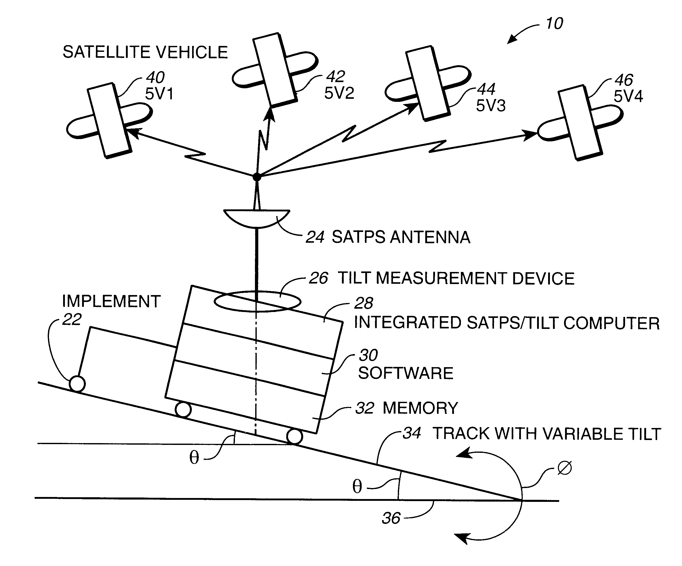
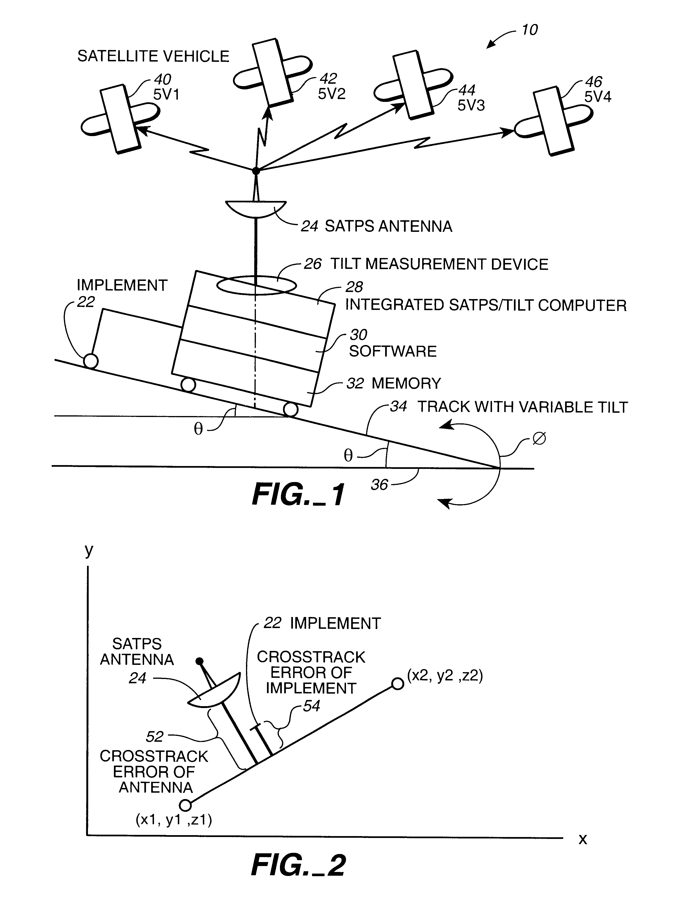
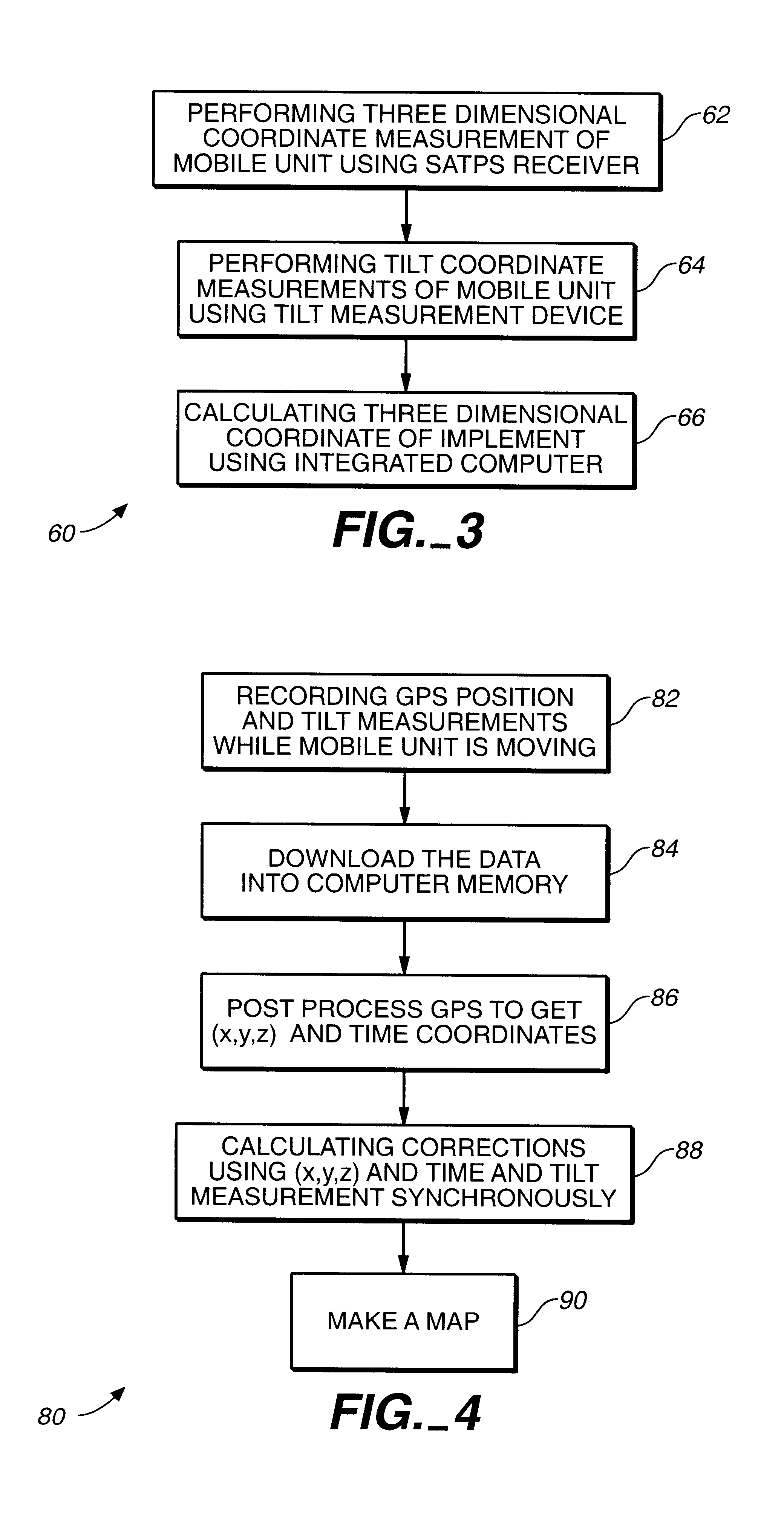
Reference will now be made in detail to the preferred embodiments of the invention, examples of which are illustrated in the accompanying drawings. While the invention will be described in conjunction with the preferred embodiments, it will be understood that they are not intended to limit the invention to these embodiments. On the contrary, the invention is intended to cover alternatives, modifications and equivalents that may be included within the spirit and scope of the invention as defined by the appended claims. Furthermore, in the following detailed description of the present invention, numerous specific details are set forth in order to provide a thorough understanding of the present invention. However, it will be obvious to one of ordinary skill in the art that the present invention may be practiced without these specific details. In other instances, well known methods, procedures, components, and circuits have not been described in detail as not to unnecessarily obscure a...


PUM


Abstract

A method of guiding a vehicle in adjacent swaths across terrain that may slope comprising the steps of: (1) determining the tilt of the vehicle with respect to Earth due to a slope of the terrain; (2) determining the position with respect to Earth of a predetermined location that is fixed relative to the vehicle; and (3) using the tilt and position determinations to provide information for guiding the vehicle to prevent gaps and overlaps between adjacent swaths as the slope changes.

Description

The current invention is in the field of the satellite navigational system.DESCRIPTION OF THE BACKGROUND ARTIn the available art relating to the satellite positional systems (SATPS), the curvature of terrain is not taken into account.Indeed, the SATPS provides the 3-D location of signal reception (for instance, the 3-D location of the antenna). However, the position of interest is often not the same as where the satellite receiver (SR) is located since the SR is placed in the location for good signal reception. For example, for a tractor towing an implement, the best location for the SR may be on top of the tractor cab, but the position of interest (POI) for providing guidance to the tractor operator may be the position on the ground below the operator. If the tractor is on a flat terrain, determining this POI is a simple adjustment to account for the antenna height. However, if the tractor is on an inclined terrain with a variable tilt, which is often the case, the SATPS alone cann...

Claims


Application Information

Patent Timeline
Patent Type & Authority Patents(United States)
IPC IPC(8): G01S5/14G01S19/04G01S19/10G01S19/14G01S19/44G01S19/53
CPCG01S19/47G01S19/40G01S19/43G01S19/41G01S19/14G01S19/39G01S19/49G05D1/0278G05D2201/0201Y02A40/10G05D1/0202
Inventor NICHOLS, MARK EDWARD
Owner TRIMBLE NAVIGATION LTD
Why Eureka
Try Eureka