Navigation of remote controlled vehicles

a remote control and vehicle technology, applied in the direction of navigation instruments, process and machine control, instruments, etc., can solve the problems of remote control vehicle misguidedness, dropout, insufficient navigation signal,

Inactive Publication Date: 2005-02-22
NORTHSTAR SYST LLC
View PDF13 Cites 84 Cited by
  • Summary
  • Abstract
  • Description
  • Claims
  • Application Information

AI Technical Summary

Benefits of technology

In other embodiments, the navigation is aimed towards maintaining the vehicle in echelon formation with other vehicles. The vehicles may be mine detection vehicles (MDVs). The GPS may be differential GPS (DGPS). The navigation using a laser tracking system and one or both of (i) a compass and (ii) wheel encoders may occur automatically upon dropout of GPS. Additionally, navigation of the vehicle may include using a physical waypoint marker upon dropout of GPS. Additionally, navigation may include using an inertial navigation system upon dropout of the GPS. A zero velocity update algorithm may be used in conjunction with the inertial navigation system.
In another embodiment, the invention involves a method for maintaining a formation of remote controlled vehicles. The vehicles are navigated using the Global Positioning System (GPS) to maintain the formation. Upon dropout of the GPS, one or more of the vehicle are navigated using a laser tracking system and one or both of: (i) a compass, and (ii) wheel encoders.

Problems solved by technology

Although GPS provides an extremely useful navigation technique, it unfortunately can experience dropouts, effectively leaving no or insufficient navigation signal for a period of time.
During a dropout period, remotely controlled vehicles may become misguided and / or fall out of formation.
In applications such as landmine clearing, this is unacceptable.
Unfortunately, each of these methods suffers from drawbacks.
Systems relying upon dead reckoning / inertial navigation systems sometimes suffer because navigation accuracy is usually time-dependent due to inherent continuous drift characteristics.
The longer inertial navigation systems are used on their own, the greater the error associated with drift.
Accordingly, the error may become so great as to overrun a maximum required navigational accuracy.
Celestial navigation typically determines position determination based on “shooting” known reference stars; this technique, however, is complicated and only works at night in good weather with limited precision.
LORAN-C suffers from limited coverage (mostly coastal) and is based upon radio signal timing, exhibiting an accuracy of only 20 to 100 meters.
Its accuracy is only 10 to 50 meters, and although its coverage is worldwide, it is non-continuous.
Despite their advantages, existing navigation systems do not utilize these techniques in combination with GPS in such a way to eliminate problems associated with GPS dropout, as disclosed herein.
The referenced shortcomings of conventional methodologies mentioned above are not intended to be exhaustive, but rather are among many that tend to impair the effectiveness of previously known techniques concerning the navigation of remote controlled vehicles.
Other noteworthy problems may also exist; however, those mentioned here are sufficient to demonstrate that methodology appearing in the art have not been altogether satisfactory and that a significant need exists for the techniques described and claimed in this disclosure.

Method used


Image

  • Navigation of remote controlled vehicles
  • Navigation of remote controlled vehicles
  • Navigation of remote controlled vehicles

Examples


examples

Tele-Operation Requirements

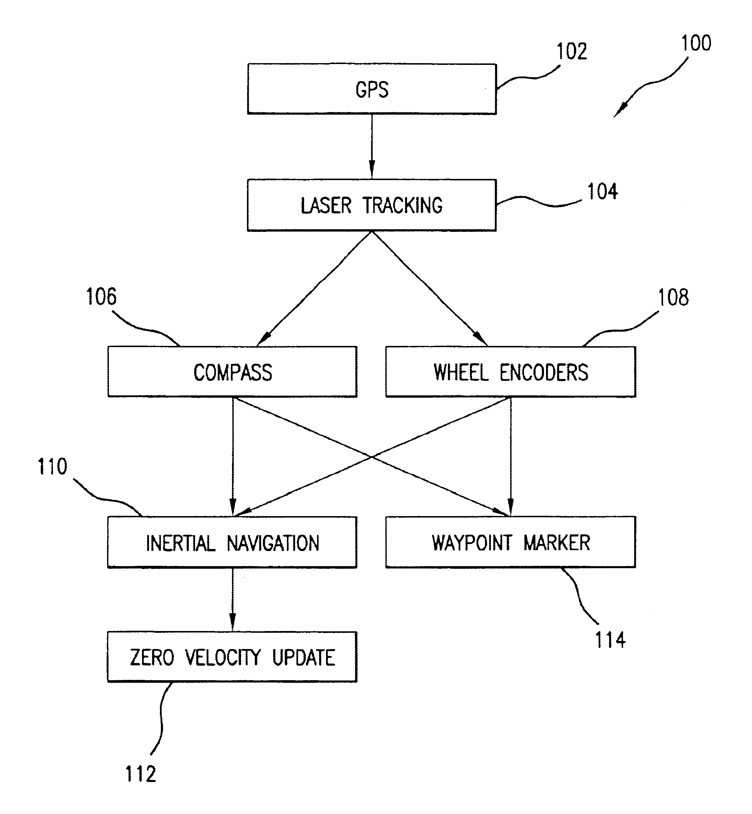
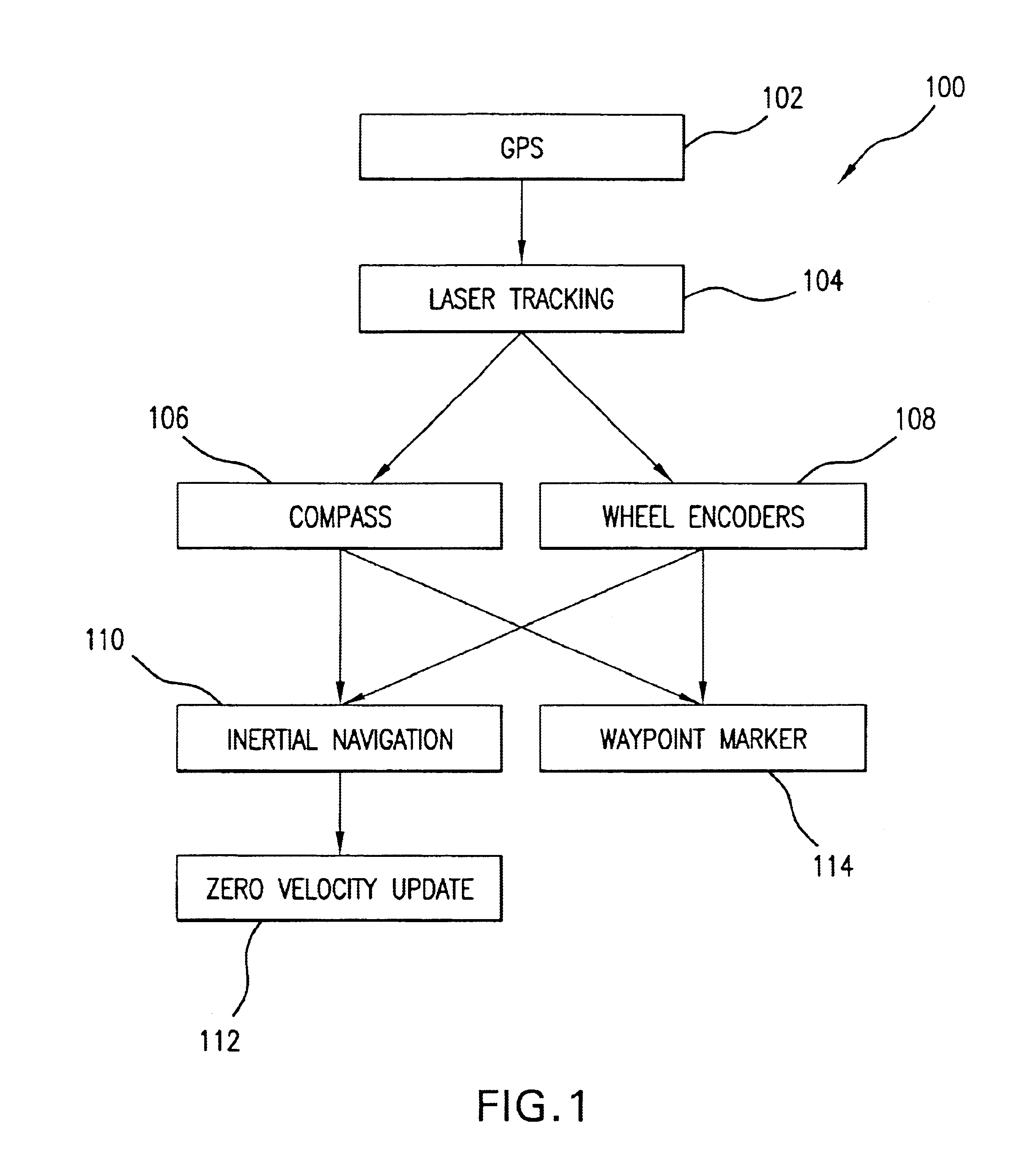
In one specific embodiment, the following may be representative of navigational requirements for landmine applications. The remote control system shall allow remote control of MDVs at all speeds up to 10 kph in mission execution mode. An administrative movement mode shall allow remote control of the vehicles at all speeds up to 40 kph. The remote control system shall provide for safe and effective remote operation of the vehicles. A maximum of three remote control systems shall be capable of simultaneous operation to support echelon movement of MDVs and up to three control vehicles. The system shall be capable of maintaining five meter minimum separation among MDVs, and 25 meter minimum separation from MDVs to control vehicles. The system shall be capable of controlling vehicles at non-line-of-sight distances of at least 300 meters. The system shall provide fail-safe features to minimize hazards from any failed tele-operation of the system.

First GPS Based ...


PUM


Abstract

Methods for navigating a remote controlled vehicle, methods for maintaining a formation of remote controlled vehicles, and remote controlled vehicles using those methods. A vehicle is navigated using the Global Positioning System (GPS). Upon dropout of the GPS, the vehicle is navigated using a laser tracking system and one or both of: (i) a compass and (ii) wheel encoders. The navigation system may be used, in one embodiment, to maintain an echelon formation of remote controlled mine detection vehicles.

Description

Aspects of this invention were made with government support under a GSTAMIDS (Ground Stand-off Mine Detection System) contract. Accordingly, the government may have certain rights in this invention.BACKGROUND OF THE INVENTION1. Field of the InventionThe present invention relates generally to the navigation of remote controlled vehicles. More particularly, it concerns the navigation of remote controlled vehicles through the combined use of differential GPS and laser tracking along with compass navigation and / or wheel encoders. Even more particularly, it concerns navigation to maintain an echelon formation of robotic vehicles useful in landmine clearing applications.2. Description of Related ArtAccurate navigation of remote controlled vehicles is important in many fields. For instance, in landmine clearing applications, one typically employs a formation of robotic, remotely controlled vehicles in echelon formation. Maintaining a proper, tight echelon formation requires accurate naviga...

Claims


Application Information

Patent Timeline
Patent Type & Authority Patents(United States)
IPC IPC(8): G01C21/10G01C21/16G05D1/02G01S19/48
CPCG01C21/165G05D1/0236G05D1/027G05D1/0278G05D1/0293G05D1/0272G05D2201/0209G01C21/1654G01C21/1652
Inventor BREAKFIELD, DAVID K.MARTIN, JERRY D.PAUL, FRED D.
Owner NORTHSTAR SYST LLC
Why Eureka
Try Eureka