
Automated borehole geology and petrophysics interpretation using image logs

a technology of image logs and geology, applied in seismology for waterlogging, using reradiation, instruments, etc., can solve the problems of reducing the application of geostatistical techniques in the field of geostatistical techniques, effectively transforming image data into a histogram, and discarding spatial information

Active Publication Date: 2006-11-07
SCHLUMBERGER TECH CORP
View PDF4 Cites 30 Cited by
  • Summary
  • Abstract
  • Description
  • Claims
  • Application Information

AI Technical Summary

Benefits of technology

[0027]Further features and applications of the present invention will become

Problems solved by technology

While these measurements contain abundant data about the subsurface, it remains a challenge to automatically extract the important geological and petrophysical knowledge contained therein.
A limitation of these approaches to automated heterogeneity analysis from borehole image interpretation is that they involve treating the borehole image as a two-dimensional image to which image processing techniques are applied.
While there is a long history of academic and industrial approaches to the automated interpretation and modeling of borehole imagery (e.g. BorTeX™), there is limited academic or applied work on the application of geostatistical techniques for this purpose.
Note however, this technique effectively collapses the image data into a histogram, discarding spatial information (other than depth).

Method used


Image

  • Automated borehole geology and petrophysics interpretation using image logs
  • Automated borehole geology and petrophysics interpretation using image logs
  • Automated borehole geology and petrophysics interpretation using image logs

Examples


Embodiment Construction

[0044]As noted above, one embodiment of the present invention provides an output of a series of single channel logs describing the geological and petrophysical heterogeneity of a borehole. While porosity (Φ) will be used as a measure of this heterogeneity, and FMI™ imagery will be used as the source measurements, one skilled in the art will recognize that other parameters and imagery sources may be suitably employed in accordance with the present invention.

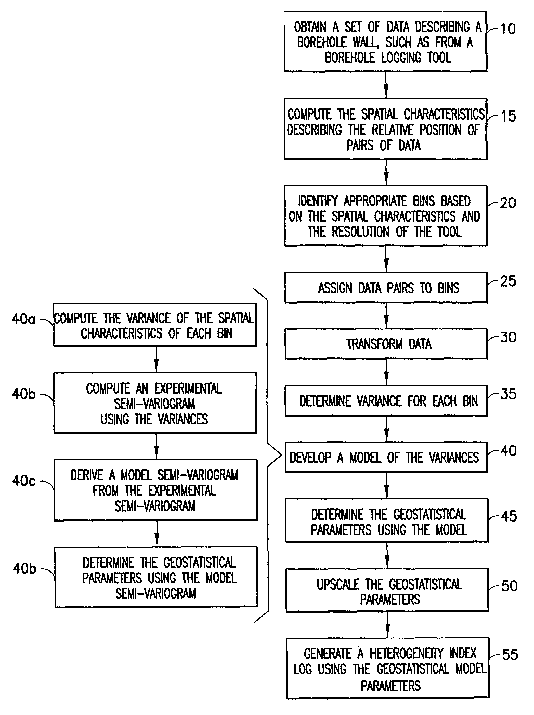
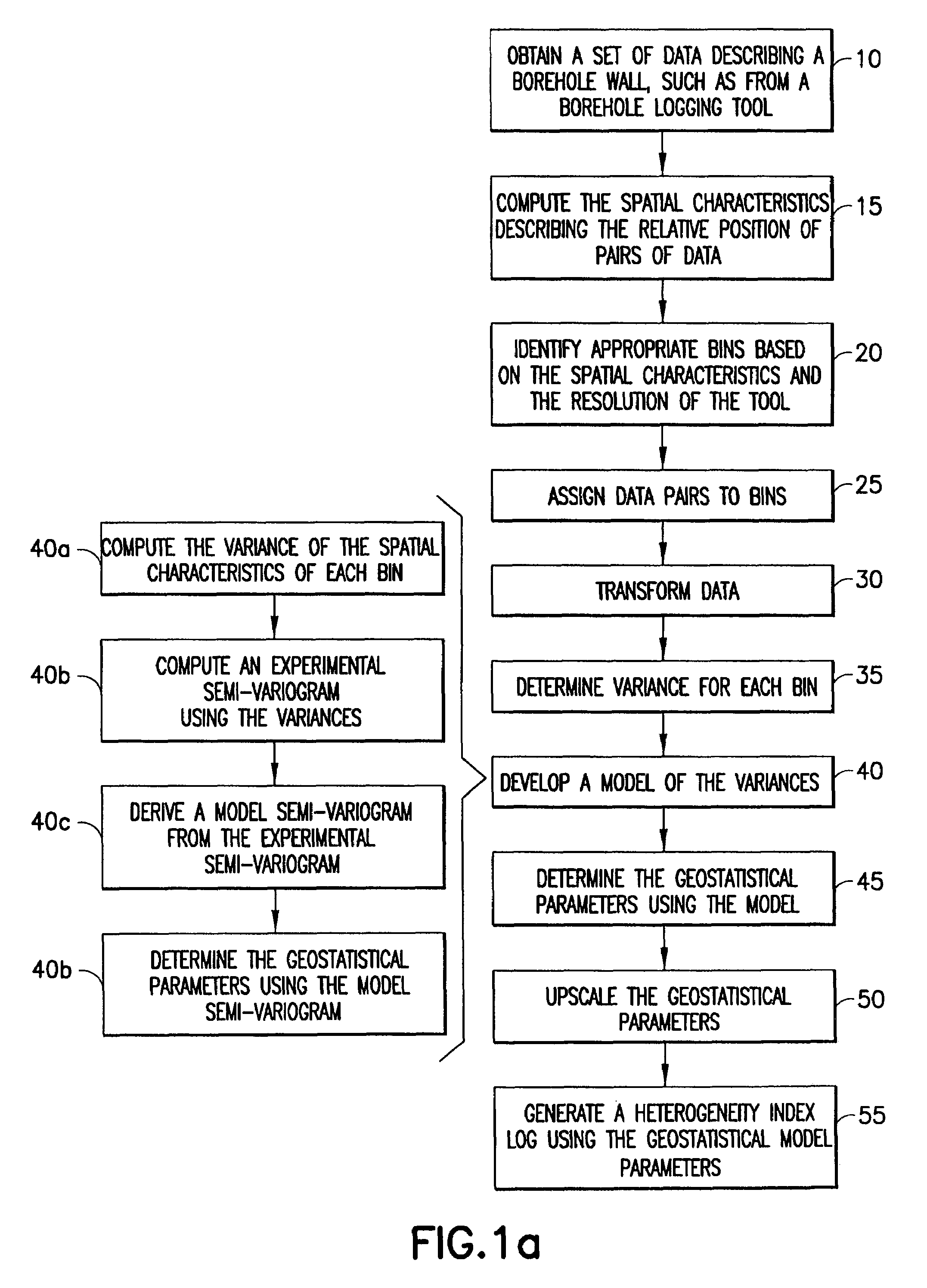
[0045]In one embodiment, the generation of the heterogeneity logs involves the following steps, as shown in FIG. 1(a):[0046]1. Obtain an array of data describing (or imaging) a section of the borehole wall, for example, a 2D array of pixels describing the borehole wall 10.[0047]2. Compute the spatial characteristics describing the relative position of the pairs of data 15. This may include calculating the coordinates (such as the 3D Cartesian coordinates) of the data from hole geometry, tool geometry, and tool orientation to deter...


PUM


Abstract

A method of characterizing a borehole traversing an earth formation including (a) obtaining an array of data from a formation characterization tool, wherein the data describes a section of the borehole; (b) computing at least one spatial characteristic describing the relative position of pairs of data; (c) assigning said pairs of data to bins based on the spatial characteristic, wherein the size of the bins are selected based on the tool; (d) transforming the data to petrophysical properties of the borehole; (e) calculating the variance of each bin; (f) developing a model of the variances; (g) determining at least one geostatistical parameter using the model; and (h) upscaling the geostatistical parameters to characterize a region of said earth formation. The method may further include generating a heterogeneity index log using the geostatistical model parameters. The method may be implemented using a computer program product for processing and interpreting borehole data.

Description

[0001]The present patent application claims priority to U.S. Provisional Patent Application No. 60 / 468,938, filed May 8, 2003, incorporated by reference herein in its entirety.FIELD OF INVENTION[0002]The present invention relates to a method to quantitatively describe the formation heterogeneity at the resolution scale of the imagery and, more particularly, to a method that applies the techniques of geometric statistics (geostatistics) to borehole imagery measurements.BACKGROUND OF THE INVENTION[0003]Borehole imagery is a major component of the wireline business (for example, Schlumberger's FMI™, Formation MicroScanner, OBMI™ Tools), and an increasing part of the logging while drilling business (Schlumberger's GeoVision™) (as described by Tilke, “Imagery in the Exploration for Oil and Gas”, published in Castelli et al., Image Databases (2002) Wiley, page 608, incorporated by reference herein in its entirety). While these measurements contain abundant data about the subsurface, it re...

Claims


Application Information

Patent Timeline
IPC IPC(8): G01V1/50G01V3/18G01V1/42G01V1/44G01V3/20
CPCG01V1/44G01V3/20
Inventor TILKE, PETER GERHARDALLEN, DAVID
Owner SCHLUMBERGER TECH CORP
Learn More