Method for spatially distributing a population

a technology of spatial distribution and population, applied in the field of modeling census data, can solve the problems of limited potential extractable information from population data, limited information about regions, and little, if any, information regarding

Active Publication Date: 2007-07-24
UT BATTELLE LLC
View PDF13 Cites 38 Cited by
  • Summary
  • Abstract
  • Description
  • Claims
  • Application Information

AI Technical Summary

Problems solved by technology

While the data collected in a simple census provides useful information, the lack of logical correlation of the population data to other factors of the region other than the boundaries of the region, limits the potential extractable information from the population data.
Consequently, simple censuses of relatively large regions provide little, if any, information regarding where individual members of a population generally live within that large region.
In many instances, people who constitute the population of a region live in highly populated areas of that region, leaving other areas of that region relatively unpopulated.
Nevertheless, simple censuses do not account for the reality of densely populated sub-regions and sparsely populated sub-regions that are within a larger region.
While a simple census provide some usefulness in determining the aggregate number of people residing in a region, some simple censuses inherently limit a systematic correlation of the location of a population throughout that region.
Such a geographic corr

Method used


Image

  • Method for spatially distributing a population
  • Method for spatially distributing a population
  • Method for spatially distributing a population

Examples


Embodiment Construction

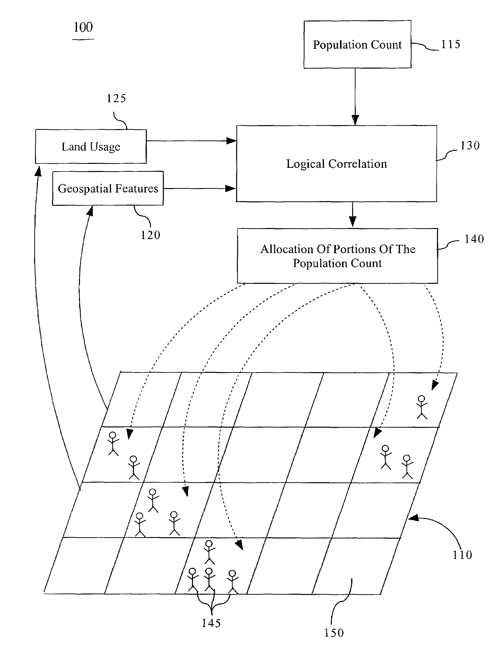
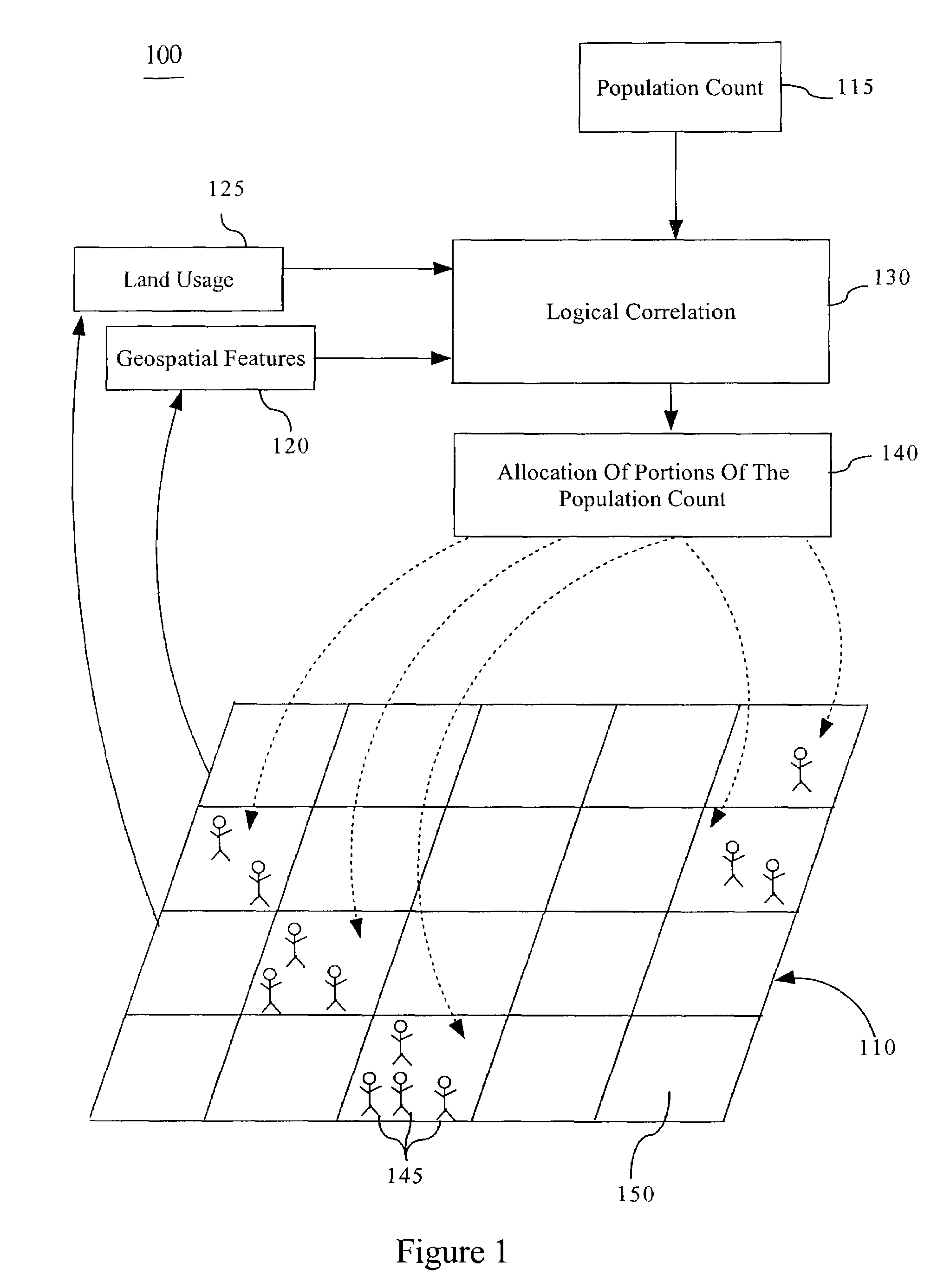
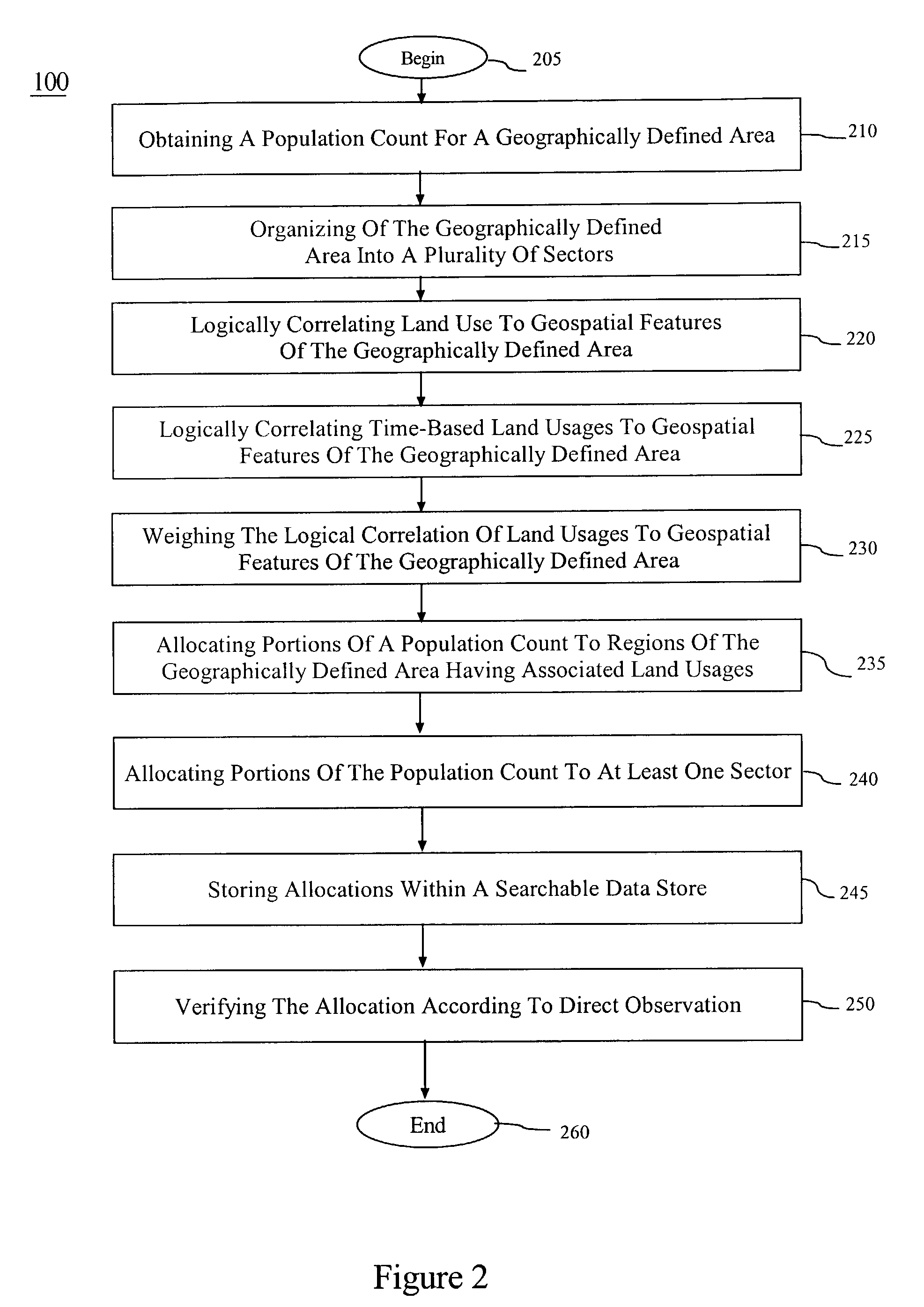
[0015]Geospatial features can include the geographic location and characteristics of natural and constructed features and boundaries of the earth and can include human bestowed characteristics, such as naming a geographically defined area. A non-exhaustive list of geospatial features can include transportation networks, such as roads, waterways, railroads, subways, and the like, slope of the land surface, night time lights, and land cover, such as desert, arid grasslands, forests, water, wetlands, cultivated lands, man-made structures and the like. A geographically defined area, by comparison, can include any land or water mass having natural boundaries, political boundaries, or arbitrarily assigned boundaries.

[0016]Unlike geospatial features in a geographically defined area, “land usage” can refer to any form of interaction with geospatial features within the geographically defined area. In this regard, land usage refers to qualitative and quantitative human interaction with the ge...


PUM


Abstract

A process for spatially distributing a population count within a geographically defined area can include the steps of logically correlating land usages apparent from a geographically defined area to geospatial features in the geographically defined area and allocating portions of the population count to regions of the geographically defined area having the land usages, according to the logical correlation. The process can also include weighing the logical correlation for determining the allocation of portions of the population count and storing the allocated portions within a searchable data store. The logically correlating step can include the step of logically correlating time-based land usages to geospatial features of the geographically defined area. The process can also include obtaining a population count for the geographically defined area, organizing the geographically defined area into a plurality of sectors, and verifying the allocated portions according to direct observation.

Description

CROSS REFERENCE TO RELATED APPLICATION[0001]Under 35 USC §119(e) this application claims the benefit of U.S. Provisional Application No. 60 / 428,616 entitled LandScan USA, filed on Nov. 22, 2002, the entirety of which is now incorporated herein by reference.STATEMENT REGARDING FEDERALLY SPONSORED RESEARCH OR DEVELOPMENT[0002]The United States Government has rights in this invention pursuant to Contract No. DE-AC05-00OR22725 between the United States Department of Energy and UT-Battelle, LLC.FIELD OF THE INVENTION[0003]The present invention relates to modeling census data, and more particularly, to modeling population distribution based geospatial data.BACKGROUND OF THE INVENTION[0004]Censuses provide a generally simple, and often used, form of collecting population data of a particular region. Since ancient Roman times, controlling bodies utilized censuses for a variety of reasons, such as counting the population that lives in a particular region. While the data collected in a simple...

Claims


Application Information

Patent Timeline
IPC IPC(8): G09B25/06G06Q10/10G09B19/00
CPCG06Q10/10G09B19/0061
Inventor BRIGHT, EDWARD A.BHADURI, BUDHENDRA L.COLEMAN, PHILLIP R.DOBSON, JEROME E.
Owner UT BATTELLE LLC
Why Eureka
Try Eureka