Parcelized geographic data medium with internal spatial indices and method and system for use and formation thereof

a geographic data and spatial index technology, applied in the field of geographic data mediums, can solve the problems of limited memory, limited computer resources of navigation systems, and limited resources of navigation system platforms, and achieve the effects of improving the accuracy of navigation system data

Inactive Publication Date: 2007-09-04
HERE GLOBAL BV
View PDF20 Cites 19 Cited by
  • Summary
  • Abstract
  • Description
  • Claims
  • Application Information

AI Technical Summary

Problems solved by technology

One difficulty in providing geographic data for use by a navigation application program relates to the efficient utilization of the available computer resources of the navigation system on which the navigation application program is run.
These types of navigation systems typically have relatively limited computer resources, such as limited memory and relatively slow I / O.
This is especially true for navigation system platforms with limited resources, such as systems installed in vehicles or hand-held systems.
Due to the limited memory resources of these navigation systems, it is necessary to load geographic data as needed from a storage medium, such as a CD-ROM, into the memory of the navigation system for use by the navigation application program.
Unfortunately, as mentioned above, in these types of systems, I / O access from a storage medium is also likely to be relatively slow.
Thus, the relatively limited memory resources combined with the relatively slow I / O can limit the performance of some types of navigation systems, resulting in slow response.
Aside from being undesirable, slow response in a navigation system may render the system useless for its intended purpose in certain circumstances.
Although techniques such as parcelization and spatial organization can enhance the use of geographic data by a navigation system, use of these techniques may be accompanied by some drawbacks.
For example, spatial searches for geographic data that do not coincide with parcel boundaries may require examination of unnecessary data records.

Method used


Image

  • Parcelized geographic data medium with internal spatial indices and method and system for use and formation thereof
  • Parcelized geographic data medium with internal spatial indices and method and system for use and formation thereof
  • Parcelized geographic data medium with internal spatial indices and method and system for use and formation thereof

Examples


example 1

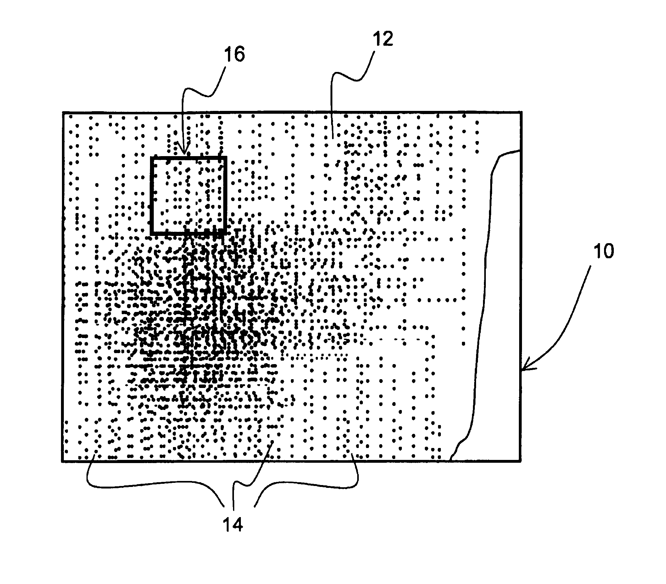
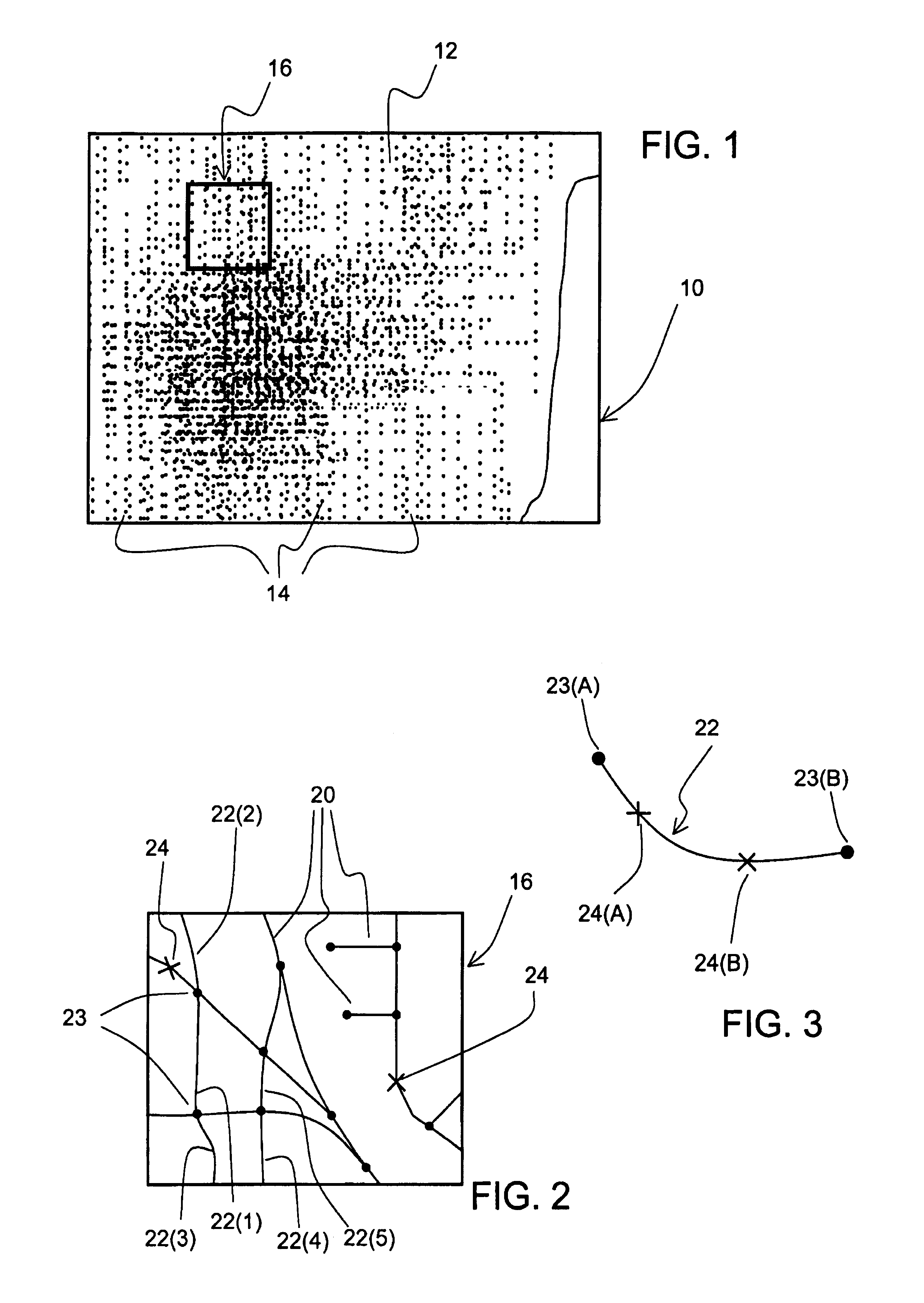
[0113]An exemplary use of a geographic database incorporating the features of the above embodiment is described in connection with FIGS. 11 and 12. A navigation system 500 uses a geographic database 530 stored on a medium 540 (such as a CD-ROM, PCMCIA card, a DVD disk, or other suitable storage medium). The navigation system 500 may be in a vehicle (not shown). The geographic database 530 is parcelized, i.e., it is separated into a plurality of parcels. Within each parcel 516 of at least one layer of at least one type of geographic data, the data are arranged internal of each of the parcels according to the embodiment described above and an internal kd-tree index 322 and bitmap 320 are provided for each parcel so arranged.

[0114]According to this example, the end-user operating the navigation system 500 may want to have the area in which he / she is located displayed on a computer display associated with the navigation system. Alternatively, the navigation system 500 may require all th...

example 2

[0121]Another exemplary use of a geographic database incorporating the features of a present embodiment is described in connection with FIGS. 12 and 13. As in the previous example, the navigation system 500 uses the parcelized geographic database 530 and within each parcel 516 of at least one layer of at least one type of geographic data, the data are arranged using sub-rectangular areas according to the embodiment described above. As further mentioned above, an internal kd-tree index 322 and bitmap 320 are provided for each parcel so arranged.

[0122]In this embodiment, the search rectangle requested by the navigation application program 520 encompasses data entities in more than one parcel. FIG. 13 shows the same geographic area 300 as shown in FIGS. 7 and 11, and in addition, FIG. 13 shows adjacent geographic areas 370, 380, and 390. Each of these geographic areas is encompassed by a separate rectangle, 302, 372, 382, and 392, respectively. The data encompassed by each of these rec...


PUM


Abstract

A navigable map database, stored on a computer-readable medium and used with a navigation application program, includes data which are spatially parcelized into a plurality of parcels. Associated with each of the plurality of parcels is a first index which associates the area represented by the data in the parcel with a plurality of sub-areas formed of the area. Also associated with each of the parcels is a second index associating each of the data in the parcel with at least one of the sub-areas. Further disclosed is a method for producing a navigable map database which is parcelized into a plurality of parcels, wherein each of the plurality of parcels includes a first index which associates the area represented by the data in the parcel with a plurality of sub-areas formed of the area and a second index associating each of the data in the parcel with at least one of the sub-areas. Also further disclosed are a program and method for finding data in one or more parcels that match a spatial search criterion using a navigable map database that is parcelized into a plurality of parcels, wherein each of the plurality of parcels includes a first index which associates the area represented by the data in the parcel with a plurality of sub-areas formed of the area and a second index associating each of the data in the parcel with at least one of the sub-areas. The program and method use the first and second indices to identify which of the data in at least one of the plurality of parcels satisfy the spatial search criterion.

Description

BACKGROUND OF THE INVENTION[0001]The present invention relates to system and method for facilitating access to and use of geographic data used with a navigation application program that provides navigating features and functions to an end user, and more particularly, the present invention relates to a geographic data medium wherein the data are organized into parcels and a method and system for the organization, storage, retrieval and use of the geographic data that facilitates the use thereof for various navigating functions provided by a navigation application program.[0002]Computer-based navigation application programs are available that provide users with various navigating functions and features. For example, some navigation application programs are able to determine an optimum route to travel by roads between locations. Using input from a user, and optionally from equipment that can determine one's physical location (such as a GPS system), a navigation application program can ...

Claims


Application Information

Patent Timeline
Patent Type & Authority Patents(United States)
IPC IPC(8): G06F17/30G01C21/00G01C21/30G08G1/123G01C21/32
CPCG01C21/32Y10S707/99942G01C21/3878G01C21/3874G01C21/3881G01C21/3863
Inventor LAMPERT, DAVID S.ASHBY, RICHARD A.FERNEKES, ROBERTMEEK, JAMES A.JAUGILAS, JOHN
Owner HERE GLOBAL BV
Why Eureka
Try Eureka