
Overlaying orthorectified aerial images with map information tied to a state plane coordinate system

a technology of state plane coordinate system and overlaying system, applied in the field of aerial image information and map information, can solve problems such as the limit of surveying accuracy

Inactive Publication Date: 2007-10-16
STEWART LAND GRP
View PDF9 Cites 45 Cited by
  • Summary
  • Abstract
  • Description
  • Claims
  • Application Information

AI Technical Summary

Problems solved by technology

In 1933 this was considered the limit of surveying accuracy.

Method used


Image

  • Overlaying orthorectified aerial images with map information tied to a state plane coordinate system
  • Overlaying orthorectified aerial images with map information tied to a state plane coordinate system
  • Overlaying orthorectified aerial images with map information tied to a state plane coordinate system

Examples


Embodiment Construction

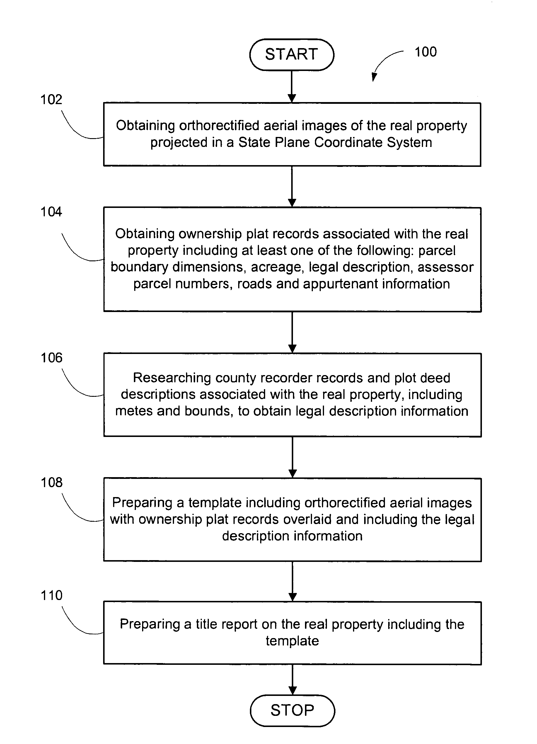
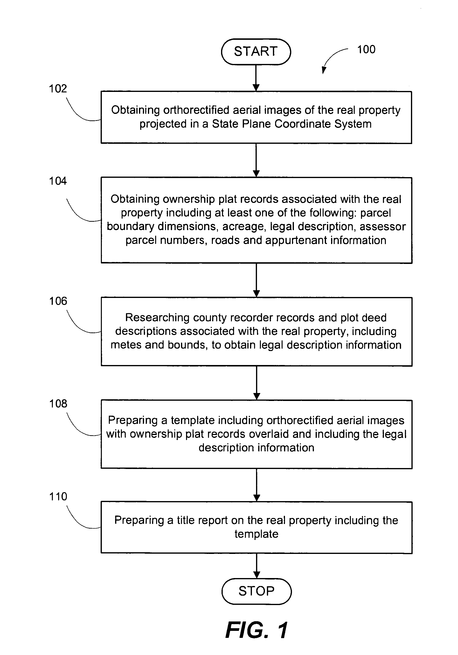
[0021]Embodiments of the present invention include a method and system for overlaying orthorectified aerial images with map information tied to the SPCS. The SPCS is a system for specifying positions of geodetic stations using plane rectangular coordinates. This coordinate system divides all fifty states of the United States, Puerto Rico, and the U.S. Virgin Islands into over 120 numbered sections, referred to as zones. Each zone has an assigned code number that defines the projection parameters for the region. Aerial images can be produced by a satellite image provider or from a provider that can use a digital format projected in a SPCS.

[0022]An embodiment of the present invention includes a method for combining data from two or more reference sources to create a picture of a specific area with orthorectified aerial imagery and a township reference plat showing each parcel boundary within a specific quarter section or sections of a township. Other embodiments consistent with the pr...


PUM


Abstract

Embodiments of the present invention include a method and system for overlaying orthorectified aerial images with map information tied to a state plane coordinate system. Computer media storing a computer program implementing an embodiment of the method of the present invention is also disclosed.

Description

CROSS REFERENCE TO RELATED APPLICATIONS[0001]This document claims priority to, and incorporated by reference all of the subject matter included in the provisional patent application, having Ser. No. 60 / 556,514 and filed on Mar. 24, 2004.BACKGROUND OF THE INVENTION[0002]1. Field of the Invention[0003]The present invention relates generally to aerial image information and map information. More particularly, this invention relates to a method and system for overlaying orthorectified aerial images with map information tied to a State Plane Coordinate System (SPCS).[0004]2. Description of Related Art[0005]The U.S. Coast Guard and Geodetic Survey created the SPCS in the 1930s in order to provide a common reference system for surveyors and cartographers. The SPCS is a grid system developed by the United States Geological Survey (USGS) in 1938 for the irregular shapes of the individual United States. SPCS is widely used in public works and land surveys. A goal in creating the SPCS was to de...

Claims


Application Information

Patent Timeline
Patent Type & Authority Patents(United States)
IPC IPC(8): G01V3/38G06F19/00
CPCG09B29/007G09B29/005
Inventor OLSEN, MICHAEL A.GURR, GARY H.
Owner STEWART LAND GRP
Learn More