Method and system for dynamic estimation and predictive route generation

a dynamic estimation and route technology, applied in the field of system and method for dynamic route estimation and prediction, can solve the problems of not accurately using the term, not providing the user with actual or estimated route information, and not providing the user with sufficient information

Inactive Publication Date: 2009-07-21
BLUESTONE VENTURES
View PDF40 Cites 130 Cited by
  • Summary
  • Abstract
  • Description
  • Claims
  • Application Information

AI Technical Summary

Benefits of technology

[0016]It is another object of the present invention to provide a method and system for providing the capability to correlate location information with a known set of network pathways associated with the particular map data for determining the point on the network pathways nearest to the location information. This allows the route calculation to be the most accurate when using location updates that typically have some positional error associated with them, and when using map data that also has its own positional error. In one embodiment, a mobile device is attached to a positioning device, such as a GPS receiver, that has a positional error typically on the order of 2-15 meters. Map data consists of various segments of roadways, each of which typically has it own positional error, sometimes on the order of 2-50 meters. Since both the mobile device and the map data typically have some positional error, and it is necessary to calculate a route using the map data, the map data is preferably used as the datum, and the mobile device's location information is “snapped-to” the nearest point or segment on the map data. That is, the location used for route calculation is preferably the point on the network pathways of the map data nearest to the actual mobile device's location. This allows the dynamic route calculation to be as accurate as possible relative to the map data and location updates from the mobile device.
[0024]It is still another object of the present invention to provide a method and system for providing the capability of adding the location update information (i.e., position information, such as GPS, etc.) and / or location information generated by a mobile device (i.e., POI, waypoint, etc.) to a route planner for the purpose of modifying the collection of discrete location history information. In one embodiment, location updates periodically arrive to a dispatch client from a mobile wireless device. The location updates can then be transferred to a route planner application that allows the modification of the location update points prior to calculating the estimated route information. For instance, if a location update illustrates a point on a specific highway, but the mobile device should have been traveling on a different highway, then that point can be moved to the appropriate highway prior to the calculation of the estimated route. Additionally, the estimated route can be calculated prior to modifying the location history update information or in real-time as the location updates arrive, since the estimated route information provides graphical information that would aid the user in modifying the location history information. In another embodiment, as location updates arrive to a dispatch client, the location update points are typically defined as via points, but the via points can be changed to other destination points, such as a stop, origin, or destination end point, thus providing route planning capabilities on the discrete location updates. Additionally, these destination points can be accompanied by additional information, such as notes, start / departure time, stop duration, etc.

Problems solved by technology

The problem with the conventional system is that the ‘breadcrumb’ trail does not provide the user with sufficient information about the mobile device's actual or estimated route during the course of its travels, but only provides discrete location information over a specified period of time.
Conventional applications will sometimes associate the term ‘route’ with a breadcrumb trail that directly connects discrete points with straight lines, but this is not an accurate use of the term as known to people that are skilled in the art.
The problem with the conventional system is that these methods and systems do not provide the user with any actual or estimated route information derived from the location updates, specifically due to the discrete nature of the location data.

Method used


Image

  • Method and system for dynamic estimation and predictive route generation
  • Method and system for dynamic estimation and predictive route generation
  • Method and system for dynamic estimation and predictive route generation

Examples


Embodiment Construction

[0058]The various embodiments of the present invention will now be described with references to FIGS. 1-26.

[0059]The present invention provides a method and system for creating, storing, and displaying dynamic route prediction and estimation using discrete sampled location update information. The dynamic route prediction and estimation can be further augmented using additional information pertaining to the location points, such as stop or waypoint information. Additional route information can be obtained from this method and system including various route metrics, such as total elapsed distance, etc. The present invention may be embodied within or along with a mapping and real-time communication application.

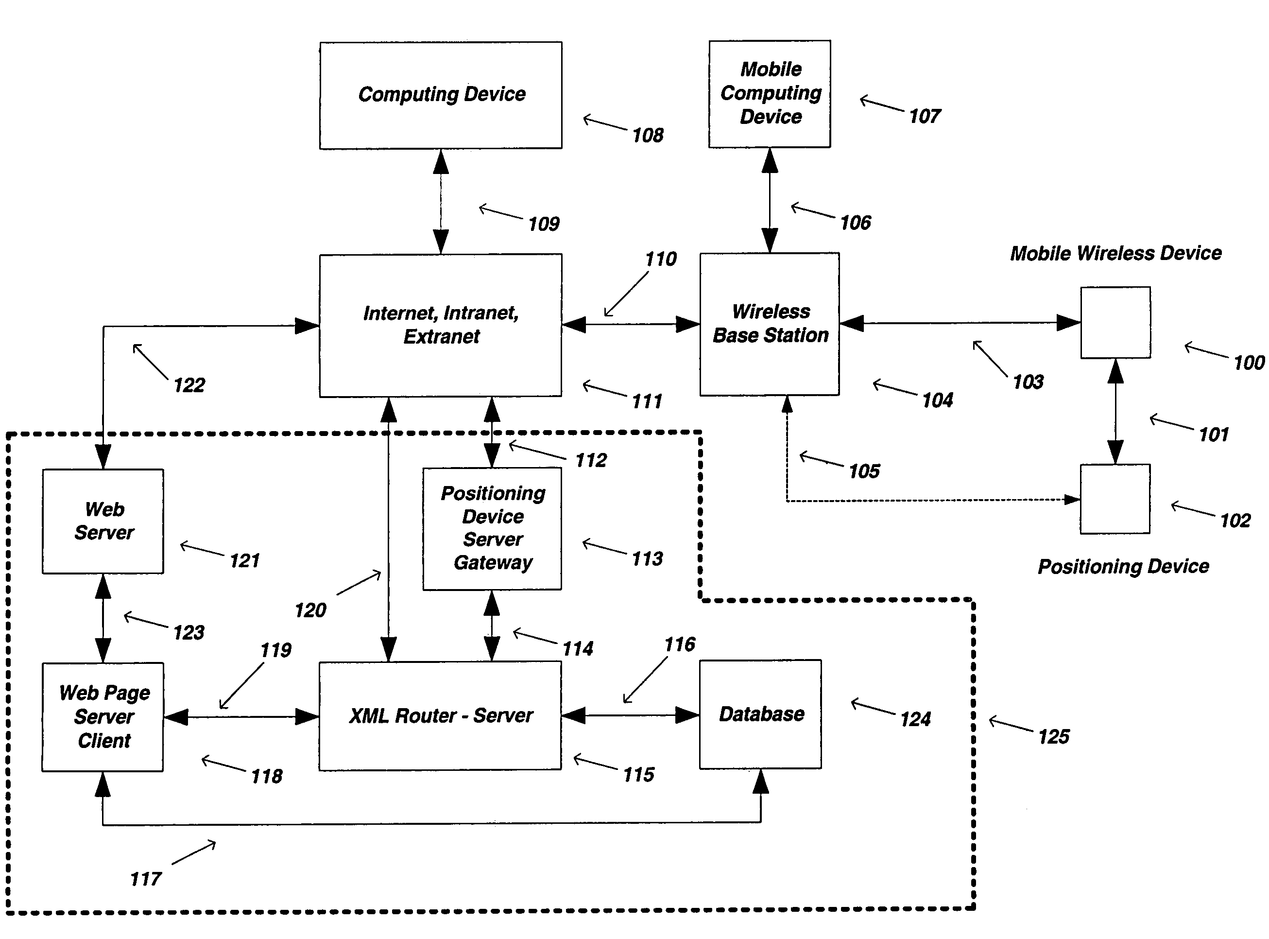
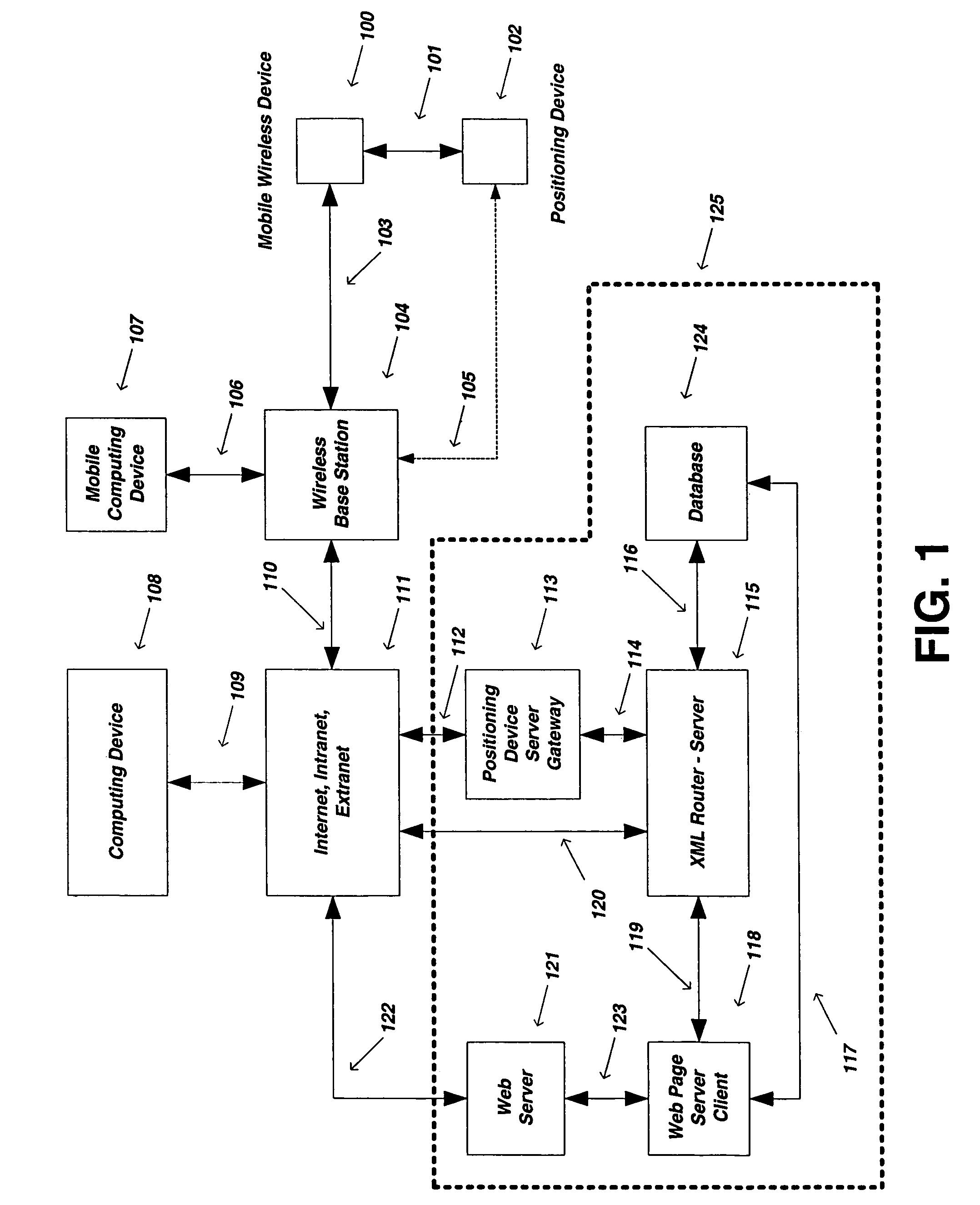
[0060]FIG. 1 illustrates a high-level diagram of an environment in which the invention may be implemented. The embodiment of the present invention will be described in the general context of an application that executes on an operating system in conjunction with a personal comput...


PUM


Abstract

The preferred embodiments of the present invention are directed to methods and systems for dynamic route estimation and prediction using discrete sampled location updates from various mobile devices for the purpose of providing a graphical representation of a mobile device's route along a known network path of map data. The embodiments also provide supplemental route metrics, such as traveled distance, elapsed time, etc., and the capability to assign destination points for the purpose of providing the ability to modify location update points in an application, such as a route planner, and / or to store the dynamically generated route based on various preferences for later retrieval.

Description

CROSS-REFERENCE TO RELATED APPLICATIONS[0001]Embodiments of the present invention claim priority from U.S. provisional patent application Ser. No. 60 / 371,941, filed Apr. 10, 2002.BACKGROUND OF THE INVENTION[0002]1. Field of Invention[0003]The present invention is directed to systems and methods for dynamic route estimation and prediction using discrete sampled location updates from various mobile devices, and to also provide supplemental information such as route metrics, including without limitation traveled distance and elapsed time.[0004]2. Description of the Related Art[0005]Computerized mapping software is achieving widespread use today. Such mapping programs are commonly used to automate tasks of calculating routes, viewing location-specific geographical areas for their spatial content, such as addresses, roadways, rivers, etc., and for the purpose of being used with Global Positioning System (GPS) devices for various applications, such as a personal navigation application. Ma...

Claims


Application Information

Patent Timeline
Patent Type & Authority Patents(United States)
IPC IPC(8): H04W24/00G01C21/34
CPCG01C21/26G01C21/34G01C21/30G06Q50/30G01C21/3438G01C21/3476G01C21/3484G01C21/3676G08G1/202G08G1/205G01C21/3415G01C21/3626G01S19/42G01C21/3469G01C21/3617G01C21/367G01C19/42
Inventor SHEHA, MICHAEL A.SHEHA, ANGIEPETILLI, STEPHENYARLAGADDA, ARUN
Owner BLUESTONE VENTURES
Why Eureka
Try Eureka