Sensor cart positioning system and method

a technology of positioning system and sensor cart, which is applied in the direction of distance measurement, instruments, and using reradiation, can solve the problems of suspect accuracy and incompleteness of current location data for buried utilities

Active Publication Date: 2012-01-03
UNDERGROUND IMAGING TECH
View PDF113 Cites 33 Cited by
  • Summary
  • Abstract
  • Description
  • Claims
  • Application Information

AI Technical Summary

Problems solved by technology

Currently-existing location data for buried utilities, however, is often incomplete and suspect in terms of accuracy.

Method used


Image

  • Sensor cart positioning system and method
  • Sensor cart positioning system and method
  • Sensor cart positioning system and method

Examples


Embodiment Construction

[0032]In the following description of the illustrated embodiments, references are made to the accompanying drawings which form a part hereof, and in which is shown by way of illustration, various embodiments in which the invention may be practiced. It is to be understood that other embodiments may be utilized, and structural and functional changes may be made without departing from the scope of the present invention.

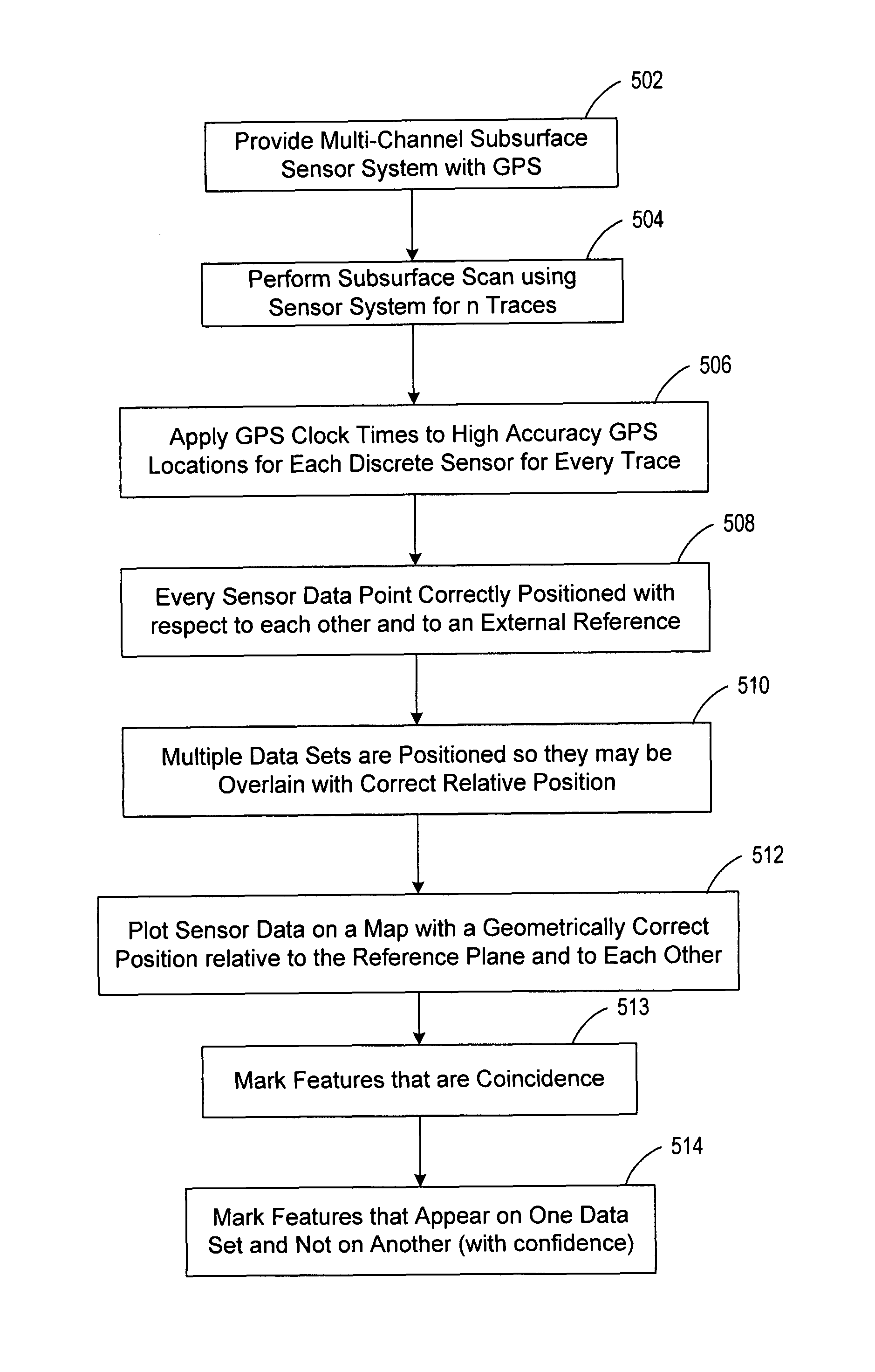
[0033]The present invention is directed to systems and methods for acquiring highly accurate positioning data for one or more sensors configured for subsurface sensing and transport over a path. The present invention is further directed to associating the sensor data with geometrically correct position data acquired for a survey path traversed by a platform, such as a cart, supporting the sensor arrangement. Geometrically correct position data, or “true geometry,” refers to very accurate positioning and co-registration of all data sets, which is achieved through use of a...


PUM


Abstract

A movable platform has a front end, a back end, a longitudinal axis, and at least one axle oriented generally transverse to the longitudinal axis and located between the front and back ends for supporting wheels of the platform. A position sensor is affixed on the platform at a location other than at a location defined by a plane passing through the axle and normal to the longitudinal axis. The position sensor provides position data as the platform traverses a path. A sensor arrangement is supported by the platform and configured to provide subsurface sensor data as the platform traverses the path. A processor is configured to associate the position data with the sensor data relative to a reference frame and in a manner that accounts for dynamic motion of the platform.

Description

RELATED APPLICATION[0001]This application claims the benefit of Provisional Patent Application Ser. No. 60 / 800,874 filed May 16, 2006, to which priority is claimed pursuant to 35 U.S.C. §119(e) and which is hereby incorporated herein by reference.FIELD OF THE INVENTION[0002]The present invention relates generally to equipment and methods used for surveying underground features. More specifically, the present invention relates to an apparatus and method for collecting subsurface survey data using a multiplicity of sensors and associating the subsurface survey data with positioning data in a manner that accounts for dynamic motion of the cart that supports the sensors, from which geometrically true positioning and co-registration of sensor data may be provided.BACKGROUND[0003]Various techniques have been developed to detect and locate underground utilities and other manmade or natural subsurface structures. It is well understood that before trenching, boring, or otherwise engaging in ...

Claims


Application Information

Patent Timeline
Patent Type & Authority Patents(United States)
IPC IPC(8): G01S13/00
CPCG01C15/00G01V1/001G01S13/885G01S13/86
Inventor JONES, ROSS PETERKELLY, PETER JOHN
Owner UNDERGROUND IMAGING TECH
Why Eureka
Try Eureka