Downhole surveying utilizing multiple measurements

a technology of multiple measurements and downhole surveys, applied in the direction of surveying, borehole/well accessories, instruments, etc., can solve the problems of more difficult correction of errors caused by disturbances affecting the relevant reference vector (e.g., earth's magnetic field), and the cost of techniques

Active Publication Date: 2012-01-10
GYRODATA
View PDF98 Cites 66 Cited by
  • Summary
  • Abstract
  • Description
  • Claims
  • Application Information

AI Technical Summary

Problems solved by technology

However, measurements used in this process can be subject to errors.
For example, the errors may be the result of imperfections internal to the instrumentation itself or external disturbances that can affect the output of the instrumentation and its associated sensors.
However, external errors, such as errors resulting from misalignments of the sensors within the wellbore, or errors caused by disturbances affecting the relevant reference vector (e.g., the Earth's magnetic field) can be more difficult to correct.
Such techniques can be costly, in part because of the additional equipment involved and because such operations are time consuming.

Method used


Image

  • Downhole surveying utilizing multiple measurements
  • Downhole surveying utilizing multiple measurements
  • Downhole surveying utilizing multiple measurements

Examples


Embodiment Construction

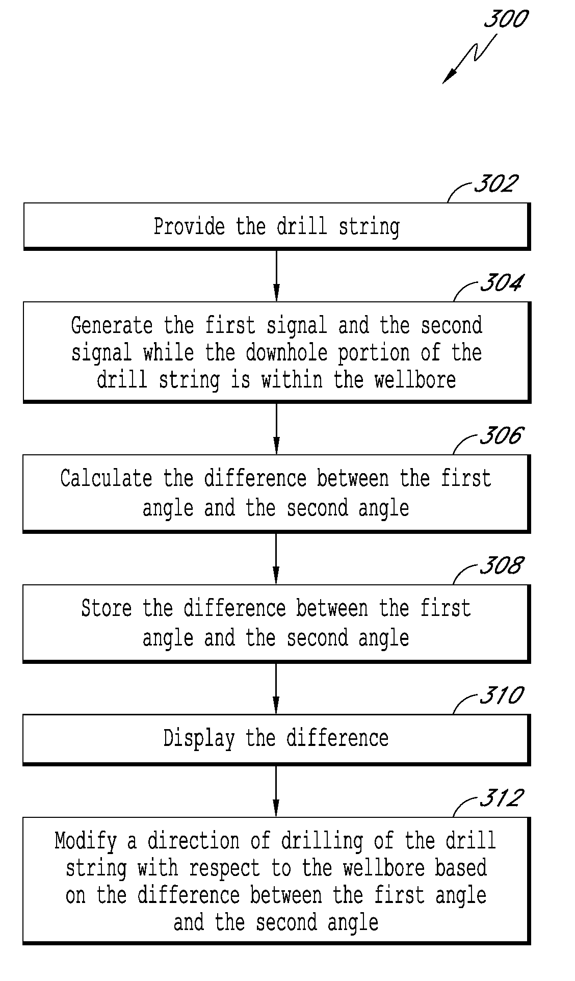
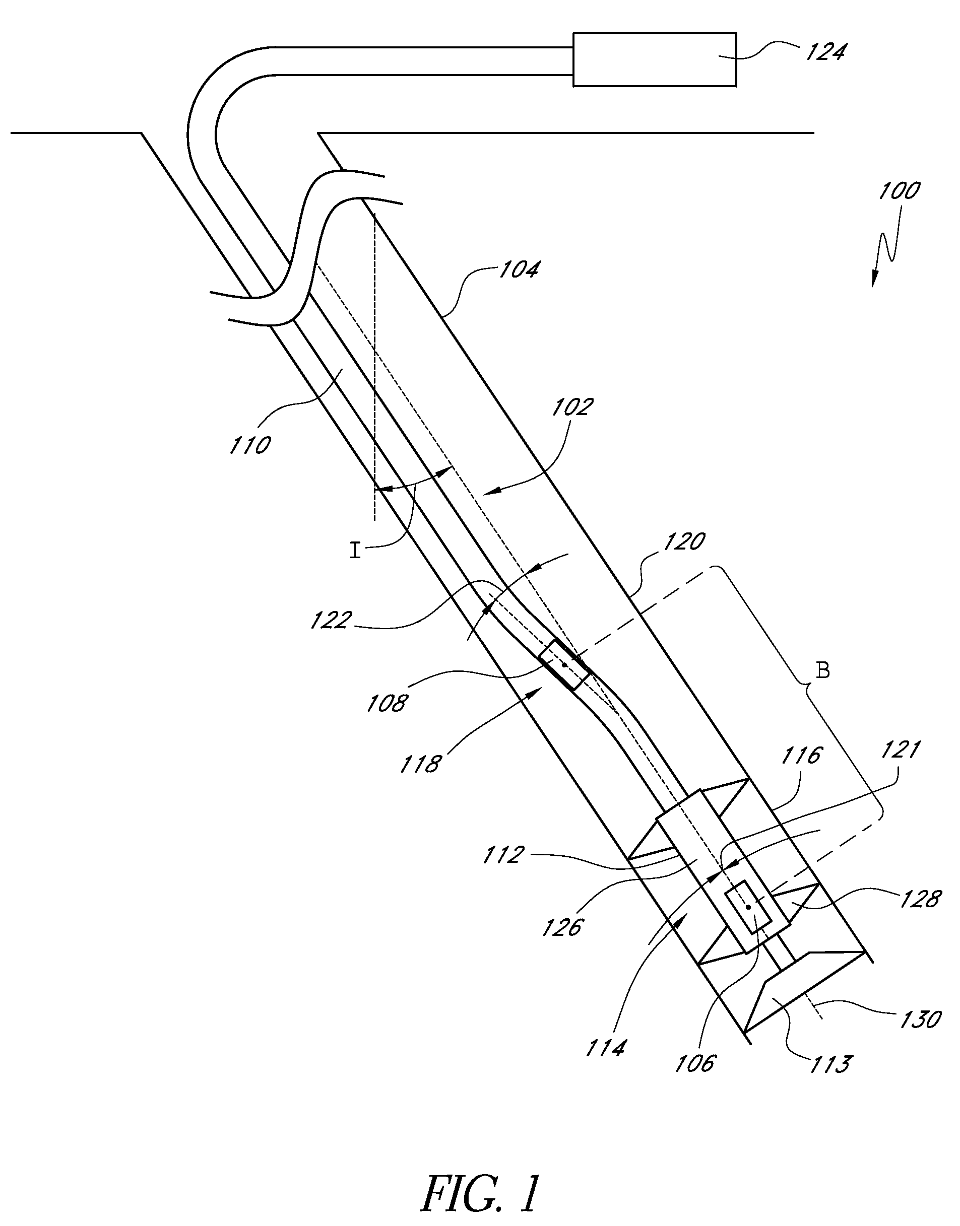
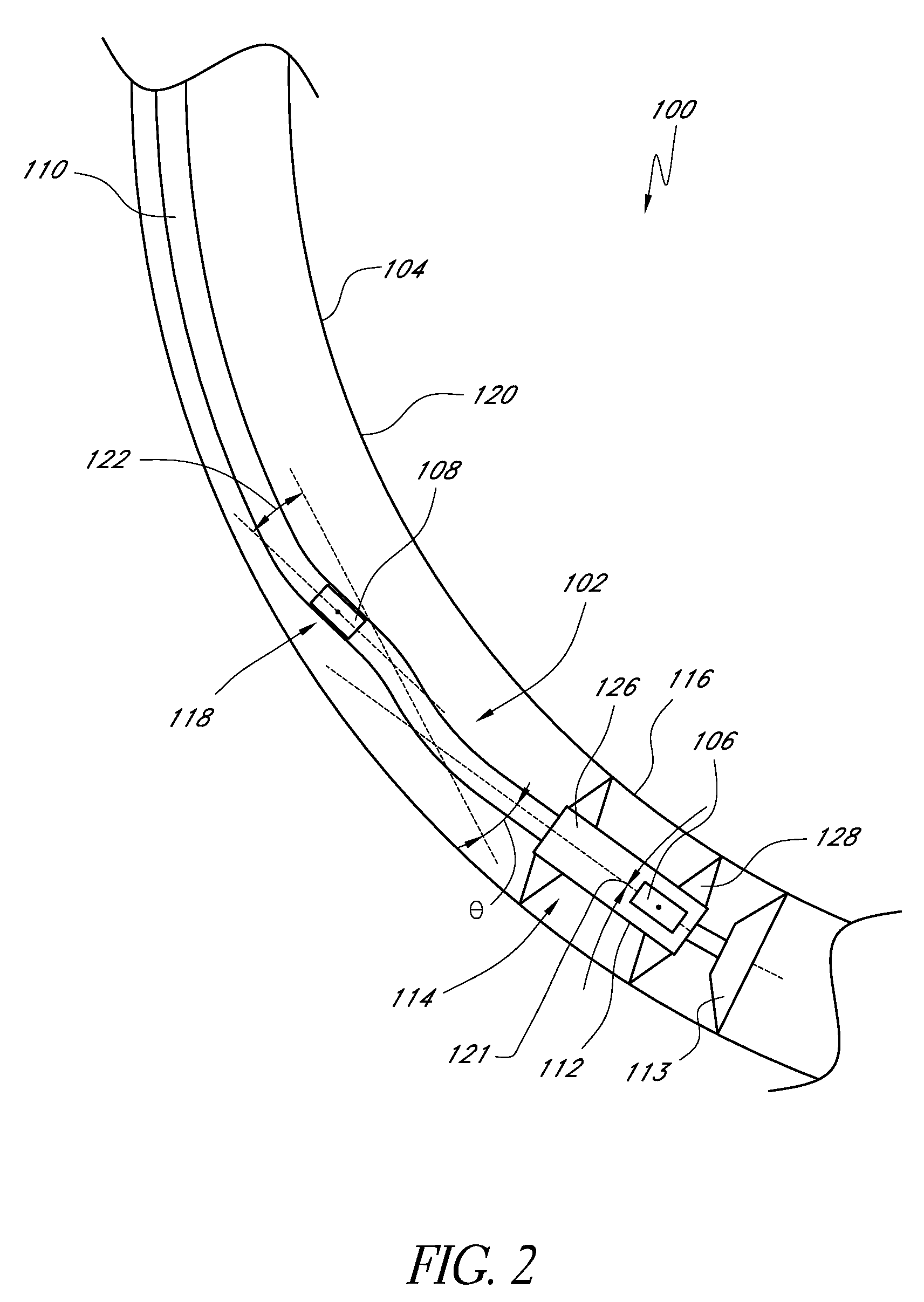
[0020]Certain embodiments described herein provide a downhole-based system for utilizing measurements from multiple sensors on a drilling tool within a wellbore to correct for measurement errors and so allow the trajectory of the well to be determined with greater accuracy than could be achieved using a single set of sensors. The application of multiple sensors also facilitates the determination of the position of the wellbore in relation to another wellbore. In certain embodiments, the system is generally used in logging and drilling applications.

[0021]In certain embodiments described herein, measurements from multiple sensors on a drill string provide improved measurement accuracy. For example, certain embodiments described herein correct for external sensor errors utilizing multiple sensors. Sensors may be included in, for example, a measurement while drilling (MWD) instrumentation pack. Additional sensors may be located on a rotary steerable tool in accordance with certain embod...


PUM


Abstract

Certain embodiments described herein provide a measure of the misalignment of multiple acceleration sensors mounted in the downhole portion of a drill string. In certain embodiments, the measure of the misalignment corresponds to a measure of sag which can be used to provide an improved estimate of the inclination of the downhole portion of the drill string and / or the wellbore. Certain embodiments described herein provide an estimate of the magnetic interference incident upon a drilling system using multiple magnetic sensors mounted within a non-magnetic region of the downhole portion of the drilling system. Certain embodiments utilize the magnetic measurements to determine an axial interference resulting from one or more magnetic portions of the downhole portion and to provide an improved estimate of the azimuthal orientation of the downhole portion with respect to the magnetic field of the Earth.

Description

BACKGROUND[0001]1. Field of the Invention[0002]The present application relates generally to systems and methods for utilizing measurements from multiple sensors on a drilling tool within a wellbore to correct for measurement errors and / or determine the position of the wellbore in relation to another wellbore.[0003]2. Description of the Related Art[0004]Rotary steerable drilling tools can be equipped with survey instrumentation, such as measurement while drilling (MWD) instrumentation, which provides information regarding the orientation of the survey tool, and hence, the orientation of the well at the tool location. Survey instrumentation can make use of various measured quantities such as one or more of acceleration, magnetic field, and angular rate to determine the orientation of the tool and the associated wellbore with respect to a reference vector such as the Earth's gravitational field, magnetic field, or rotation vector. The determination of such directional information at ge...

Claims


Application Information

Patent Timeline
Patent Type & Authority Patents(United States)
IPC IPC(8): G06F19/00
CPCE21B47/022G01V3/38G01V3/26
Inventor EKSETH, ROGERWESTON, JOHN LIONEL
Owner GYRODATA
Why Eureka
Try Eureka