Virtual white lines (VWL) for delimiting planned excavation sites of staged excavation projects

Inactive Publication Date: 2013-02-26
CERTUSVIEW TECH LLC
View PDF230 Cites 44 Cited by
  • Summary
  • Abstract
  • Description
  • Claims
  • Application Information

AI Technical Summary

Benefits of technology

[0012]A further embodiment is directed to an apparatus for facilitating detection of a presence or an absence of at least one underground facility within a dig area, wherein at least a portion of the dig area may be excavated or disturbed during excavation activities. The apparatus comprises: a communication interface; a display device; at least one user input device; a memory to store processor-executable instructions; and a processing unit coupled to the communication interface, the display device, the at least one user input device, and the memory, wherein upon execution of the processor-executable instructions by the processing unit. The processing unit: controls the communication interface to electronically receive source data representing at least one input image of a geographic area including the first dig area and the at least one additional dig area, wherein the first dig area corresponds to a first stage of an staged excavation project and the at least one additional dig area corresponds to at least one subsequent stage of the staged excavation project; controls the display device to display at least a portion of the at least one input image; acquires at least one first user input from the at least one user input device; generates a first generation marked-up digital image including at least one first indicator overlaid on the at least one input image to provide at least one indication of the first dig area; acquires at least one second user input from the at least one user input device; generates a multi-generational marked-up digital image including at least one additional indicator overlaid on the first generation marked-up digital image to provide at least one indication of the at least one additional dig area; and further controls the communication interface and/or the memory to electronically transmit and/or electronically store information relating to the multi-generational marked-up digital image so as to facilitate the detection of the presence or the absence of the at least one underground facility within the plurality of dig areas.
[0013]Another embodiment is directed to a method for facilitating detection of a presence or an absence of at least one underground facility within a plurality of dig areas comprising a first dig area and a second dig area, wherein at least a portion of the first and second dig areas may be excavated or disturbed during excavation activities. The method comprises: A) electronically receiving first source data representing a first input image of a geographic area including a first dig area, wherein the first dig area corresponds to a first stage of an staged excavation project; B) processing the first source data so as to display at least a portion of the first input image on the display device; C) adding, via at least one user input device associated with the display device, at least one first indicator to the displayed first input image to provide at least one indication of the first dig area and thereby generate a first marked-up digital image; D) electronically receiving second source data representing a second input image of a geographic area including a second dig area, wherein the second dig area corresponds to a subsequent stage of the staged excavation project; E) processing the second source data so as to display at least a portion of the second input image on the display device; F) adding, via the at least one user input device, at least one second indicator to the displayed second input image to provide at least one indication of the second dig area and thereby generate a second marked-up digital image; and G) electronically transmitting and/or electronically storing first information relating to the first marked-up digital image together with second information relating to the second marked-up digital image so as to facilitate the detection of the presence or the absence of the at least one underground facility within the first and second dig areas.
[0014]A further embodiment is directed to at least one computer-readable medium encoded with instructions that, when executed by at least one processing unit, perform a method for facilitating detection of a presence or an absence of at least one underground facility within a dig area, wherein at least a portion of the dig area may be excavated or disturbed during excavation activities. The method comprises: A) electronically receiving first source data representing a first input image of a geographic area including a first dig area, wherein the first dig area corresponds to a first stage of an staged excavation project; B) processing the first source data so as to display at least a portion of the first input image on the display device; C

Problems solved by technology

However, the use of these physical white lines to physically delimit the dig area may be limited.
Currently, with respect to multiple-stage excavation projects, the communication process between excavators and locate technicians may be poorly coordinated due to poor infrastructure and, therefore, the day-to-day activities of excavators and locate personnel may be poorly synchronized.
As a result, there is a risk of locate operations occurring at the wrong subsections of the project dig area and/or at the wron

Method used


Image

  • Virtual white lines (VWL) for delimiting planned excavation sites of staged excavation projects
  • Virtual white lines (VWL) for delimiting planned excavation sites of staged excavation projects
  • Virtual white lines (VWL) for delimiting planned excavation sites of staged excavation projects

Examples


Embodiment Construction

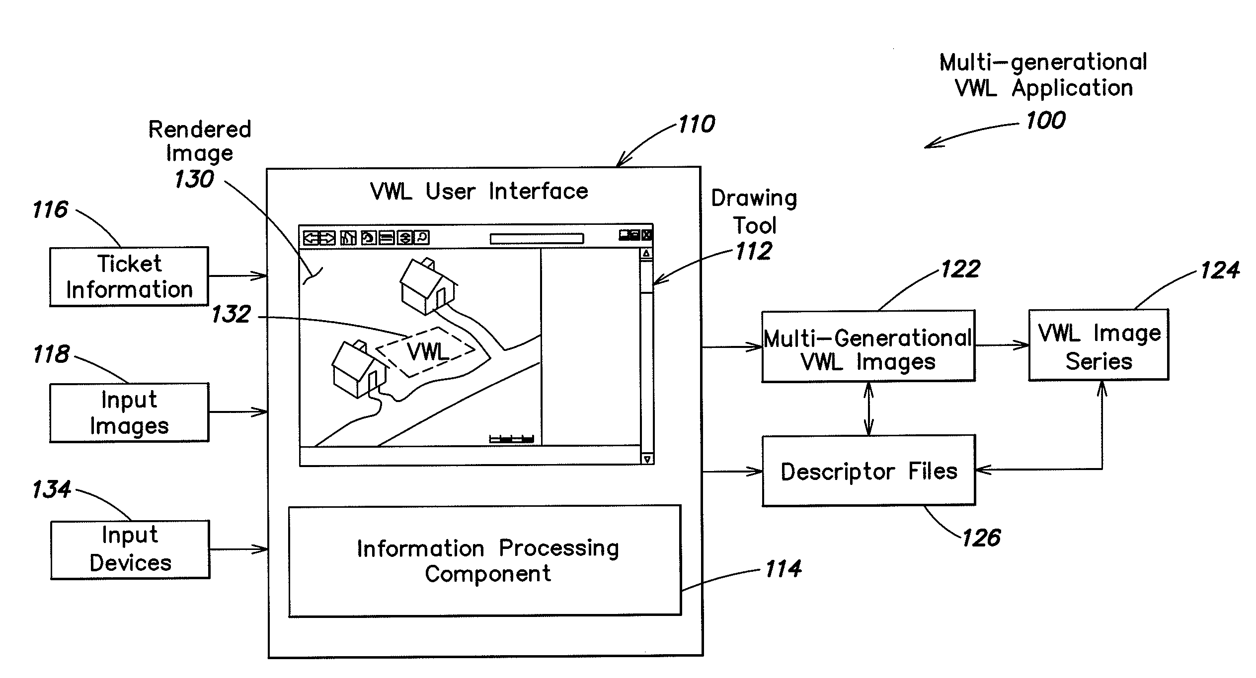
[0041]Following below are more detailed descriptions of various concepts related to, and embodiments of, inventive methods and apparatus according to the present disclosure for associating one or more virtual white line images with corresponding ticket information for a given excavation project. It should be appreciated that various concepts introduced above and discussed in greater detail below may be implemented in any of numerous ways, as the disclosed concepts are not limited to any particular manner of implementation. Examples of specific implementations and applications are provided primarily for illustrative purposes.

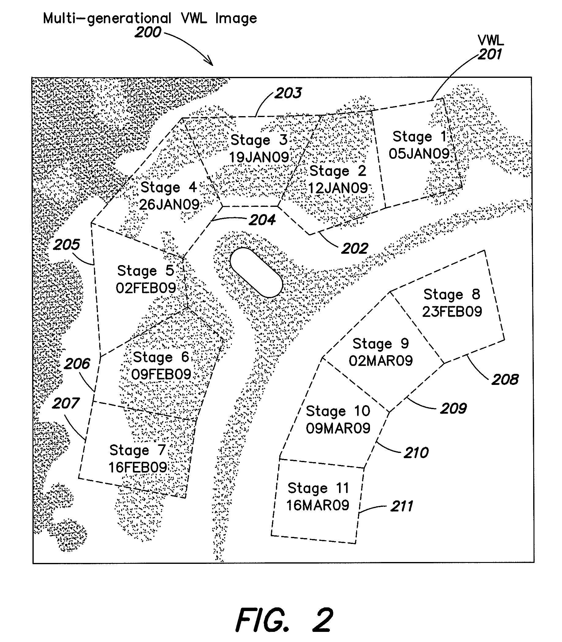
[0042]Various embodiments described herein are directed to methods, apparatus and systems for creating an electronic record relating to a geographic area including a dig area to be excavated or otherwise disturbed. The electronic record may comprise one or more virtual white line (VWL) images for delimiting one or more planned excavation sites. In some examples, ...


PUM


Abstract

Methods and apparatus for facilitating detection of a presence or an absence of at least one underground facility within a dig area. Source data representing one or more input images of a geographic area including the dig area is electronically received at a first user location, which may be remote from the dig area. The source data is processed so as to display at least a portion of the input image(s) on a display device. One or more indicators are added to the displayed input image(s), via a user input device associated with the display device, to provide at least one indication of the dig area and thereby generate a marked-up digital image. In the case of a staged excavation project, the input image, or a plurality of associated images, may include indicia of multiple dig areas corresponding to multiple stages of the staged excavation project.

Description

CROSS-REFERENCE TO RELATED APPLICATIONS[0001]This application claims the benefit, under 35 U.S.C. §119(e), of U.S. Provisional Application Ser. No. 61 / 151,769, entitled “MULTI-GENERATIONAL VIRTUAL WHITE LINES (VWL) FOR DELIMITING PLANNED EXCAVATION SITES OF STAGED EXCAVATION PROJECTS,” filed on Feb. 11, 2009, which is hereby incorporated herein by reference in its entirety.BACKGROUND[0002]Excavators are required to notify underground facility owners in advance of their excavation activities and to describe and communicate the geographic area of those activities to the underground facility owners. As a result, excavators may submit a work order (i.e., locate request or ticket) to, for example, a one-call center, which serves as notification to underground facility owners. A locate request (or ticket) may be any communication or instruction to perform a locate operation at a certain dig area, which is any specified geographic area within which excavation may occur. One call centers ma...

Claims


Application Information

Patent Timeline
IPC IPC(8): G09G5/00G06F3/048
CPCG06Q10/06311G07B15/00G06Q10/06313G06T11/203G06T11/60G06T2210/61
Inventor NIELSEN, STEVEN E.CHAMBERS, CURTISFARR, JEFFREY
Owner CERTUSVIEW TECH LLC
Why Eureka
Try Eureka