Portable base station network for local differential GNSS corrections

a technology of local differential and base station network, applied in satellite radio beaconing, measurement devices, instruments, etc., can solve problems such as discrepancies of half a meter or more, and achieve the effect of improving the repeatability of the rover location

Active Publication Date: 2014-08-12
AGJUNCTION
View PDF31 Cites 35 Cited by
  • Summary
  • Abstract
  • Description
  • Claims
  • Application Information

AI Technical Summary

Benefits of technology

[0016]With the present invention the rover transmits these offsets over its radio link to the secondary base station for application to its correction data, which will then be conformed to align with the master base station correction data, thus eliminating the base-station-transition correction data jump. Correction data from the master and the secondary base stations thus align relatively precisely, thereby enabling seamless centimeter-level guidance as the rover travels from the master to the secondary base station coverage area.
[0018]The rover positioning system processor can define a list of base stations and their respective coverage area polygons for automatically switching the rover receiver frequencies to receive the correction signals from the base station(s) within range. The hysteresis effect maintains the rover receiver in contact with a current base station until the rover exits its coverage area polygon, whereupon correction data is received from another base station, to which the rover has transmitted the applicable master-to-secondary location coordinate offsets over the radio link. Likewise, the hysteresis effect will maintain the radio contact with the secondary base station until the rover leaves its coverage area, whereupon coverage from the master (or another secondary) base station seamlessly resumes.
[0019]The system can also save previously-generated secondary base location corrections for use in future operations, as described in U.S. Pat. No. 7,400,294, which is incorporated herein by reference. For example, if a secondary base receiver antenna is returned to within a defined distance (e.g., 5 m) from a previously-generated, saved secondary base station location, the secondary base location will be generated by averaging GNSS locations at that point, and corrections will be generated from rover-transmitted master base station correction data, as described above. An extra message will be transmitted from the secondary base station to the rover with the saved, previously-generated, secondary base location corrections. Saved base station locations can thus be reused for improving rover location repeatability for accurate relative positioning from previous DGNSS-guided operations within the coverage area.

Problems solved by technology

Merely averaging the inconsistent position correctors from the master and second base stations can still result in discrepancies of half a meter or more.

Method used


Image

  • Portable base station network for local differential GNSS corrections
  • Portable base station network for local differential GNSS corrections
  • Portable base station network for local differential GNSS corrections

Examples


Embodiment Construction

I. Introduction and Environment

[0027]As required, detailed aspects of the disclosed subject matter are disclosed herein; however, it is to be understood that the disclosed aspects are merely exemplary of the invention, which may be embodied in various forms. Therefore, specific structural and functional details disclosed herein are not to be interpreted as limiting, but merely as a basis for the claims and as a representative basis for teaching one skilled in the art how to variously employ the present invention in virtually any appropriately detailed structure.

[0028]Certain terminology will be used in the following description for convenience in reference only and will not be limiting. For example, up, down, front, back, right and left refer to the invention as orientated in the view being referred to. Said terminology will include the words specifically mentioned, derivatives thereof and words of similar meaning.

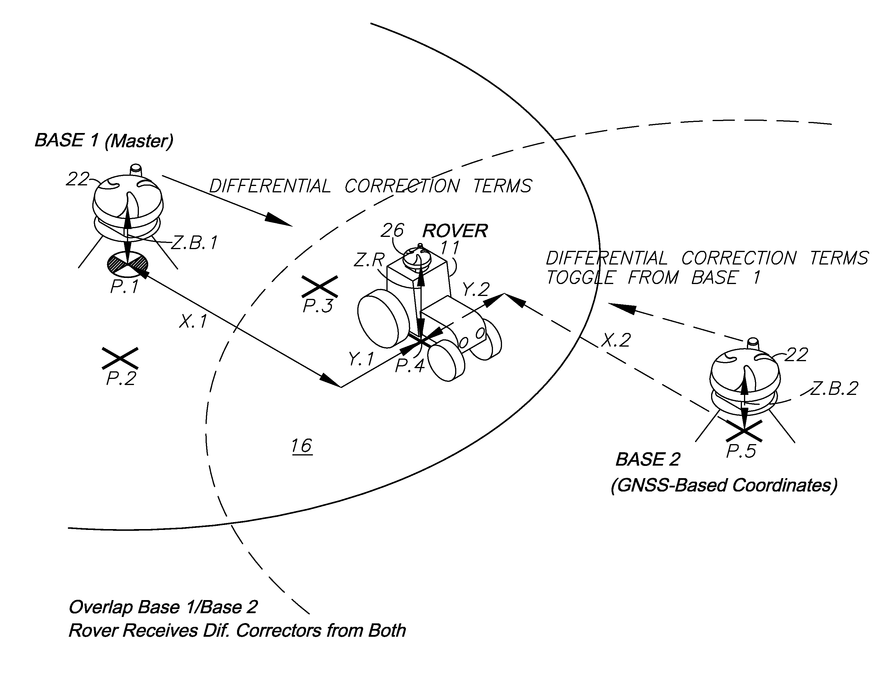
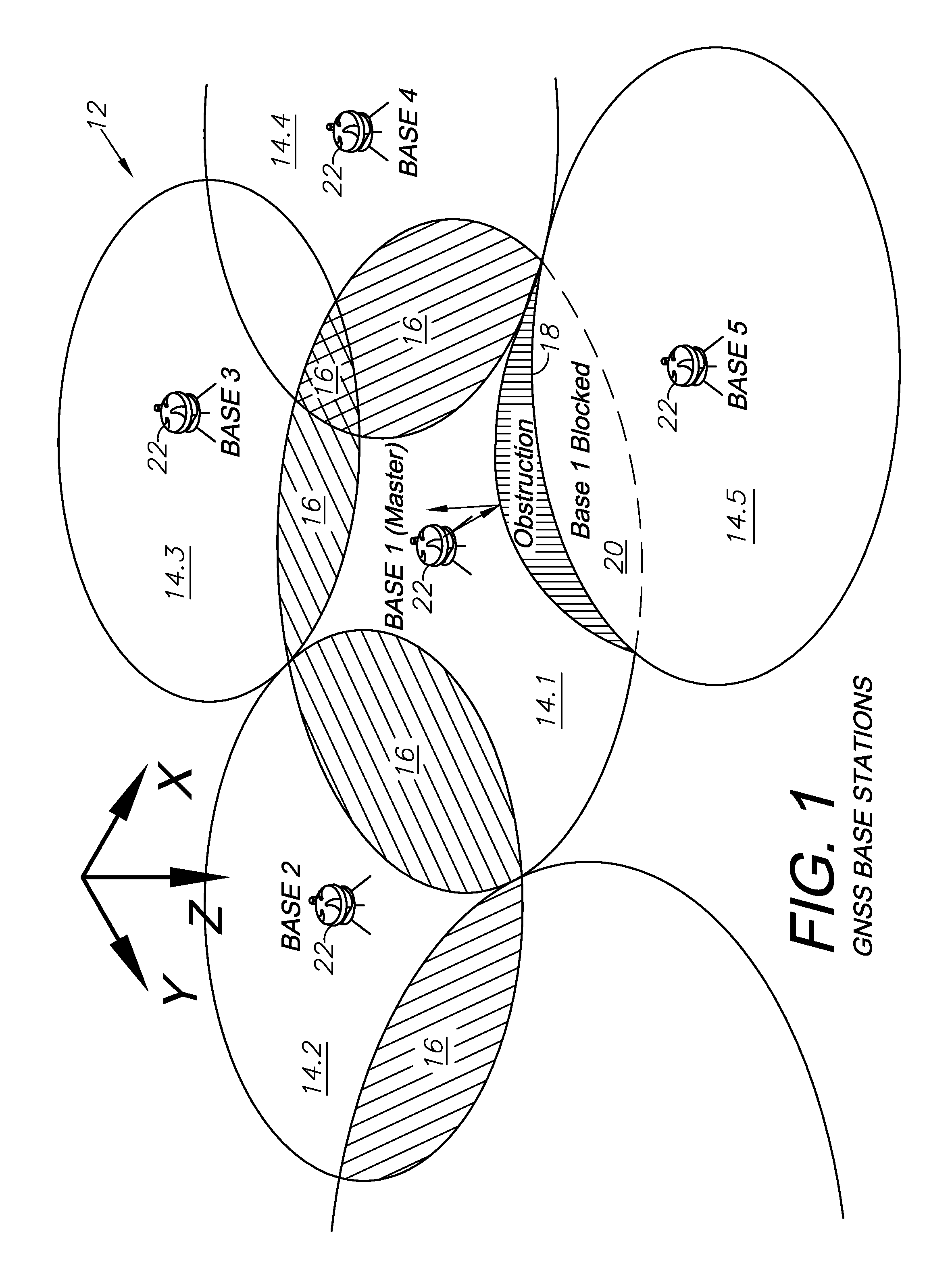
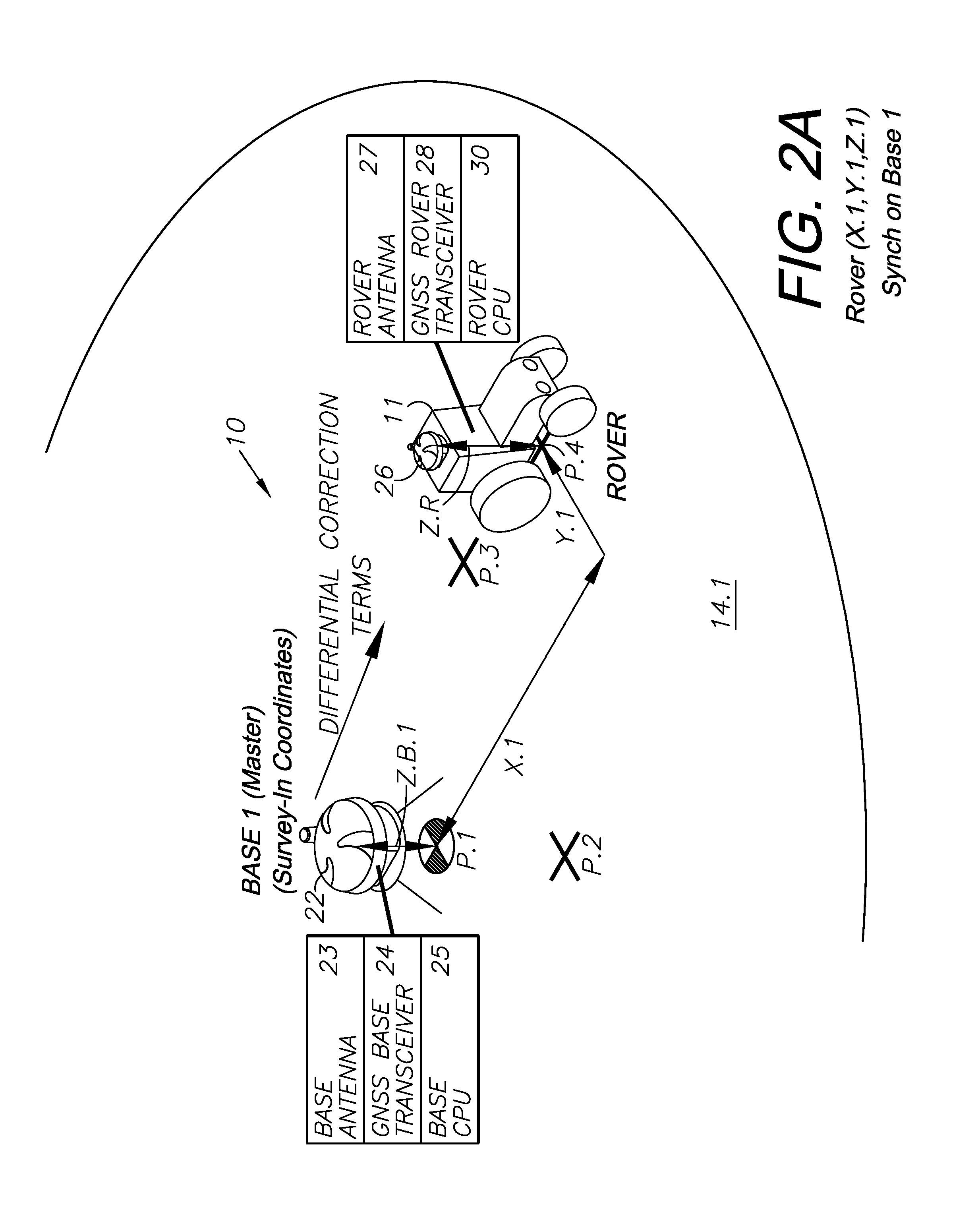
[0029]Generally, a preferred embodiment of the present invention cons...


PUM


Abstract

A DGNSS-based guidance system, wherein a rover receiver first utilizes data from a master base station transceiver, a DGNSS reference network, or some other differential source to compute a differentially corrected location to establish a reference DGNSS relationship. Using this location and data observed only at the rover, the rover computes an internal set of differential corrections, which set is stored in computer memory, updated as necessary, and applied in future times to correct observations taken by the rover. As the rover enters into areas of other base station receiver reference networks, the rover transceiver will send positional information it receives from the master base station to the new, secondary base station. The secondary base station then calibrates its own reference information using information sent from the original master base station.

Description

CROSS-REFERENCE TO RELATED APPLICATION[0001]This application claims priority in U.S. Provisional Patent Application No. 61 / 415,693, filed Nov. 19, 2010, which is incorporated herein by reference.BACKGROUND OF THE INVENTION[0002]1. Field of the Invention[0003]The present invention relates generally to Global Navigation Satellite System (GNSS) base stations, and in particular to calibrating a network of portable, secondary base or reference stations in relation to a master base station for differential GNSS correction over a coverage region comprising multiple overlapping coverage polygons.[0004]2. Description of the Related Art[0005]Differential GNSS techniques have been successfully applied for a number of years. These techniques, for example, enable accurate real-time positioning of a rover receiver relative to a base receiver. This positioning includes code-only or carrier-smoothed-code differential techniques that result in sub-meter accuracy, such as those employed while operati...

Claims


Application Information

Patent Timeline
Patent Type & Authority Patents(United States)
IPC IPC(8): G01S19/41G01S19/07
CPCG01S19/07G01S19/13G01S19/071
Inventor MCCLURE, JOHN, A.
Owner AGJUNCTION
Why Eureka
Try Eureka