Navigation by ocean surface topography

a topography and ocean technology, applied in navigation instruments, maps/plans/charts, instruments, etc., can solve problems such as the disruption of gps signals and rf beacons, and the inability to see celestial objects

Active Publication Date: 2017-05-16
CHARLES STARK DRAPER LABORATORY
View PDF7 Cites 5 Cited by
  • Summary
  • Abstract
  • Description
  • Claims
  • Application Information

AI Technical Summary

Problems solved by technology

However, each of these has disadvantages.
GPS signals and RF beacons are subject to disruption, such as by destruction or jamming by an enemy.
Celestial sightings may not be available due to cloud cover or at a given time of day, such as during daylight hours.

Method used


Image

  • Navigation by ocean surface topography
  • Navigation by ocean surface topography
  • Navigation by ocean surface topography

Examples


Embodiment Construction

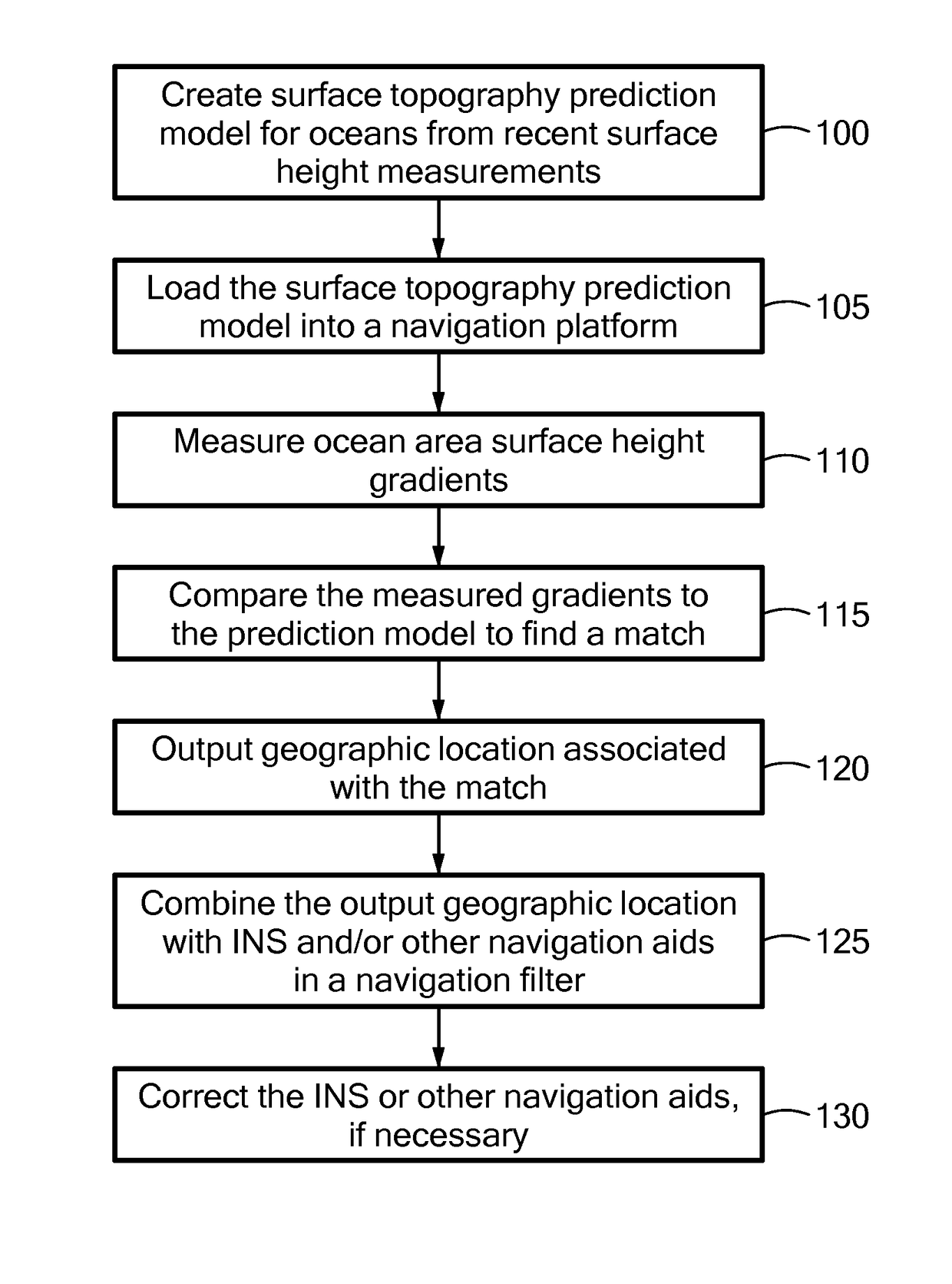
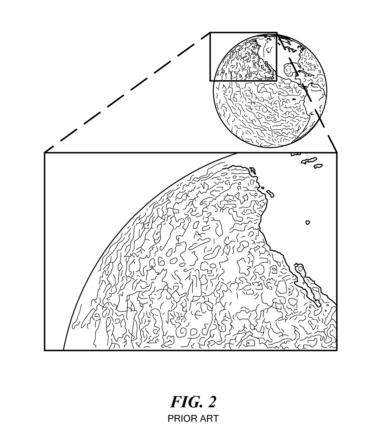
[0004]Embodiments of the present invention provide systems and methods for using ocean surface gradients, primarily surface height gradients, for navigation. A system or method compares observed (measured) surface gradients to a catalog of known gradients and / or to gradients predicted by a model to ascertain its location. Although surface height gradients are the primary features matched, other surface gradients, such as temperature, water current and color, may be used. Ocean topography (meaning mapped surface gradients) is dynamic. However, some ocean topographic features remain relatively stable for days or weeks. Furthermore, most ocean topographic features can be predicted, based on historical ocean topographic data, known viscosities of ocean water, ocean currents, prevailing winds and the like, in some cases augmented with weather predictions, known time of year (season), etc. Essentially, the system uses known and / or predicted ocean surface gradients as geographic landmarks....


PUM


Abstract

Methods and apparatus ascertain a geographic position based on topographic contours of ocean surfaces. Observed ocean topographic contours are matched to predicted ocean topography and / or ocean topographic information stored in a database. Such systems and methods do not necessarily require INS, GPS, RF beacons, optical beacons or celestial sightings. These systems and methods may be used as references to correct INS. These systems and methods may be used to ascertain a geographic location of an aircraft, spacecraft, watercraft, landcraft (vehicle), person or the like. Similarly, these systems and methods may be used as part of a guidance system for guiding a craft to a destination. These systems and methods may be used in tandem with, or as backups for, other types of navigation or guidance systems or as one input to a navigation filter.

Description

CROSS REFERENCE TO RELATED APPLICATIONS[0001]This application claims the benefit of U.S. Provisional Patent Application No. 61 / 968,738, filed Mar. 21, 2014, titled “Navigation by Ocean Surface Topography,” the entire contents of which are hereby incorporated by reference herein, for all purposes.TECHNICAL FIELD[0002]The present invention relates to geographic positioning and, more particularly, to determining a geographic position by matching observed ocean topography to known or predicted ocean topography.BACKGROUND ART[0003]Most known position determining or navigation systems and methods used above the surface of the earth depend on inertial navigation systems (INS), global positioning systems (GPS), radio-frequency (RF) location beacons, optical location beacons and / or celestial sightings. However, each of these has disadvantages. For example, INS systems drift over time and need to be periodically or occasionally corrected with aiding references, such as from a GPS. GPS signals...

Claims


Application Information

Patent Timeline
Patent Type & Authority Patents(United States)
IPC IPC(8): G01C21/20G06F17/10G06F17/50G09B29/10G01C21/00
CPCG09B29/10G01C21/005G01C21/20G06F17/10G06F17/5009G06F30/20
Inventor LAINE, JUHA-PEKKA J.BLASCHE, GREGORY P.BOHN, PAULDAWSON, ROBIN MARK ADRIANFOLEY, WALTERLANE, BENJAMIN F.MCCLAIN, SEANWALDRON, ERIK L.SMITH, STEPHEN P.
Owner CHARLES STARK DRAPER LABORATORY
Why Eureka
Try Eureka