Fusion of RGB images and LiDAR data for lane classification

a technology of lane classification and fusion of color images and point cloud data, applied in image enhancement, reradiation, instruments, etc., can solve the problems of high cost of lidar data acquisition to acquire frequent changes in lane markings, difficulty in accurate current image-based lane marking and classification, and inability to accommodate a variety of driving and lighting conditions

Active Publication Date: 2017-07-18
NOKIA TECH OY
View PDF10 Cites 44 Cited by
  • Summary
  • Abstract
  • Description
  • Claims
  • Application Information

AI Technical Summary

Problems solved by technology

There is a high cost in the use of LiDAR data acquisition to acquire frequent changes in lane markings.
The accuracy of current image-based lane marking and classification is further challenging due to lighting, time of day, occlusions, and the shear variety of markers.
Some conventional handcrafted methods relying on one or two dimensional filters fail to accommodate a variety of driving and lighting conditions.
One challenge in using this information is the presence of other high intensity areas in the point cloud data set, which may include guardrails, cars, grass, road signs, and the like.
Additionally, the illustrations are merely representational and may not be drawn to scale.

Method used


Image

  • Fusion of RGB images and LiDAR data for lane classification
  • Fusion of RGB images and LiDAR data for lane classification
  • Fusion of RGB images and LiDAR data for lane classification

Examples


Embodiment Construction

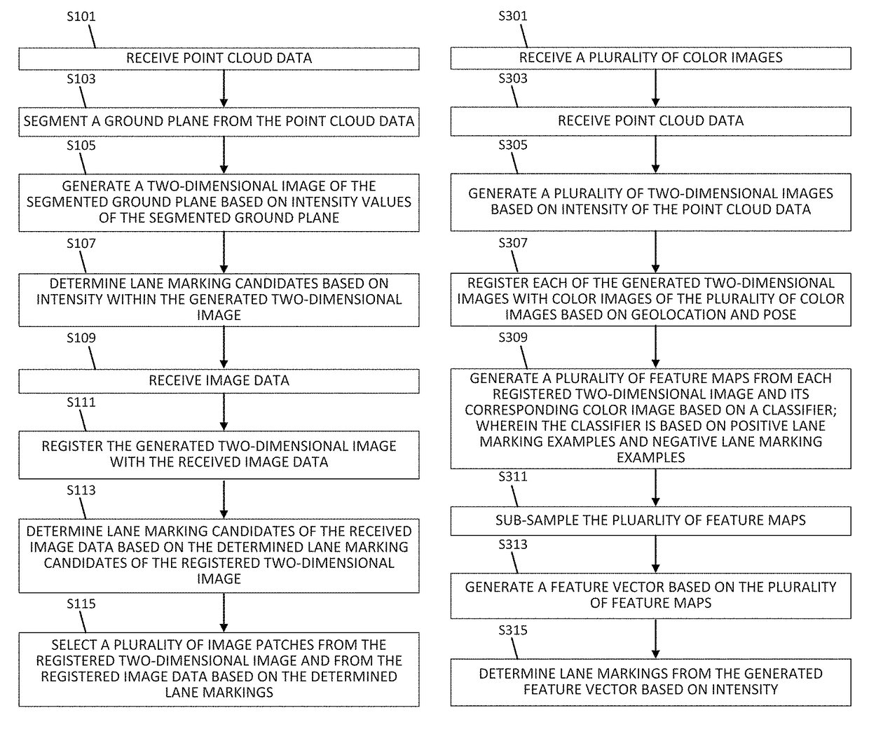
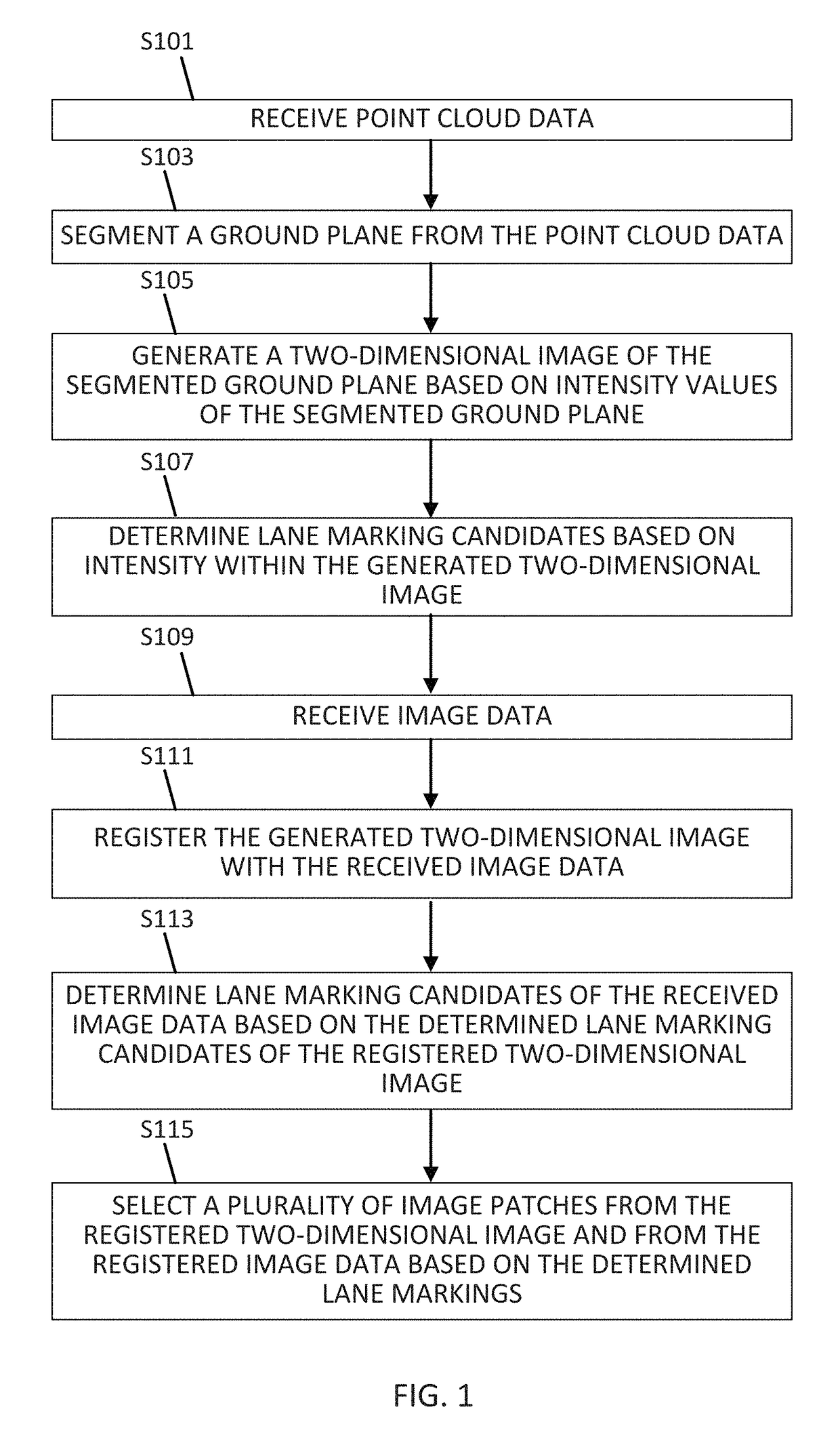
[0019]Lane markings may be painted on roadways using reflective paint. The reflectivity of the paint can be identified in point cloud data set based on its infrared reflective intensity. One challenge in using this information is the presence of other high intensity areas in the point cloud data set, which may include guardrails, cars, grass, road signs, and the like. Machine learning algorithms can be used to remove areas of high intensity that are not lane markings. The subject technology for lane classification uses the fusion of color images and point cloud intensity data train convolutional neural networks (CNNs) in order to classify image patches as lane markings and non-lane markings.

[0020]One goal of the disclosure is to use the fusion of point cloud data and images to extract lane markings. A further goal of the disclosure is to depart from handcrafted feature approaches by using deep learning methods to determine lane markings and classification. A further goal of the disc...


PUM


Abstract

Point cloud data is received and a ground plane is segmented. A two-dimensional image of the segmented ground plane is generated based on intensity values of the segmented ground plane. Lane marking candidates are determined based on intensity within the generated two-dimensional image. Image data is received and the generated two-dimensional image is registered with the received image data. Lane marking candidates of the received image data are determined based on the lane marking candidates of the registered two-dimensional image. Image patches are selected from the two-dimensional image and from the received image data based on the determined lane markings. Feature maps including selected image patches from the registered two-dimensional image and received data are generated. The set of feature maps are sub-sampled, and a feature vector is generated based on the set of feature maps. Lane markings are determined from the generated feature vector.

Description

FIELD[0001]The following disclosure relates to identifying road markings such as lanes through image processing, and more particularly, to the fusion of color images and point cloud data using convolutional neural networks for lane classification.BACKGROUND[0002]Computer based navigation systems such as autonomous driving vehicles and map-aided localization have created a need for lane detection and lane classification from road images. Lane detection and classification is frequently established based on video, photographs, scans, existing maps and point cloud data (such as remote sensing using infrared lasers, often called Light Detection And Ranging, or LiDAR) information collected. One approach to identification of these markers is the extraction of markers based on color, shape, or other image features from street level imagery. Construction and changes to roadway systems create a constantly changing environment, requiring continual maintenance and upkeep of maps to provide curr...

Claims


Application Information

Patent Timeline
Patent Type & Authority Patents(United States)
IPC IPC(8): G06K9/00G01S17/02G06T7/40G06T5/50G06T7/00G06K9/48G06K9/32G01S17/89G01S17/86
CPCG06K9/00798G01S17/02G06K9/3241G06K9/481G06T5/50G06T7/44G06T7/42G06T2207/10028G06T2207/20221G01S17/89G01S17/86G06V20/64G06V20/588G06V10/454G06V10/806G06F18/253
Inventor CHEN, XINZANG, ANDIHUANG, XINYU
Owner NOKIA TECH OY
Why Eureka
Try Eureka