Unlock instant, AI-driven research and patent intelligence for your innovation.
Real time extracting method for satellite remote sensing sea fog characteristic quantity
What is Al technical title?
Al technical title is built by PatSnap Al team. It summarizes the technical point description of the patent document.
An extraction method and satellite remote sensing technology, which is applied in the field of marine environment monitoring, can solve the problems of not being able to extract sea fog feature quantities, separating no fog from low clouds, and being unable to provide information for sea fog dispersal forecasts, etc., to achieve enhanced observation and recognition capabilities, Effect of Spectral Resolution Improvement
Inactive Publication Date: 2010-12-22
OCEAN UNIV OF CHINA
View PDF3 Cites 0 Cited by
Summary
Abstract
Description
Claims
Application Information
AI Technical Summary
This helps you quickly interpret patents by identifying the three key elements:
Problems solved by technology
Method used
Benefits of technology
Problems solved by technology
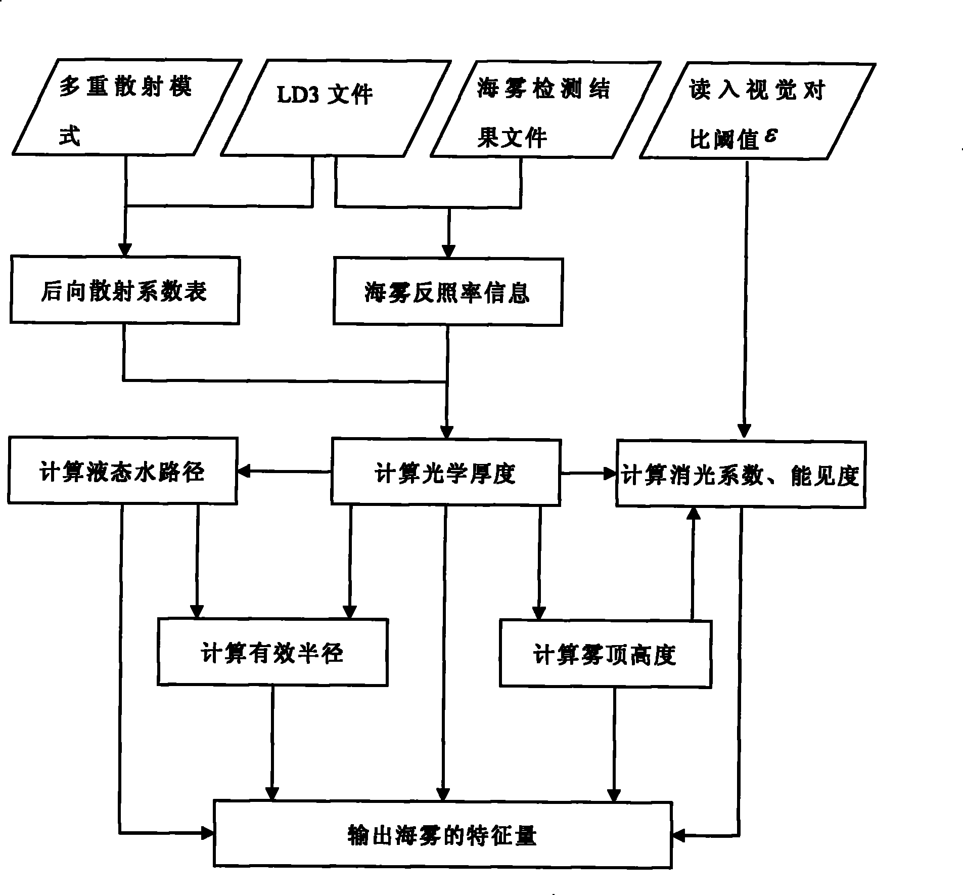
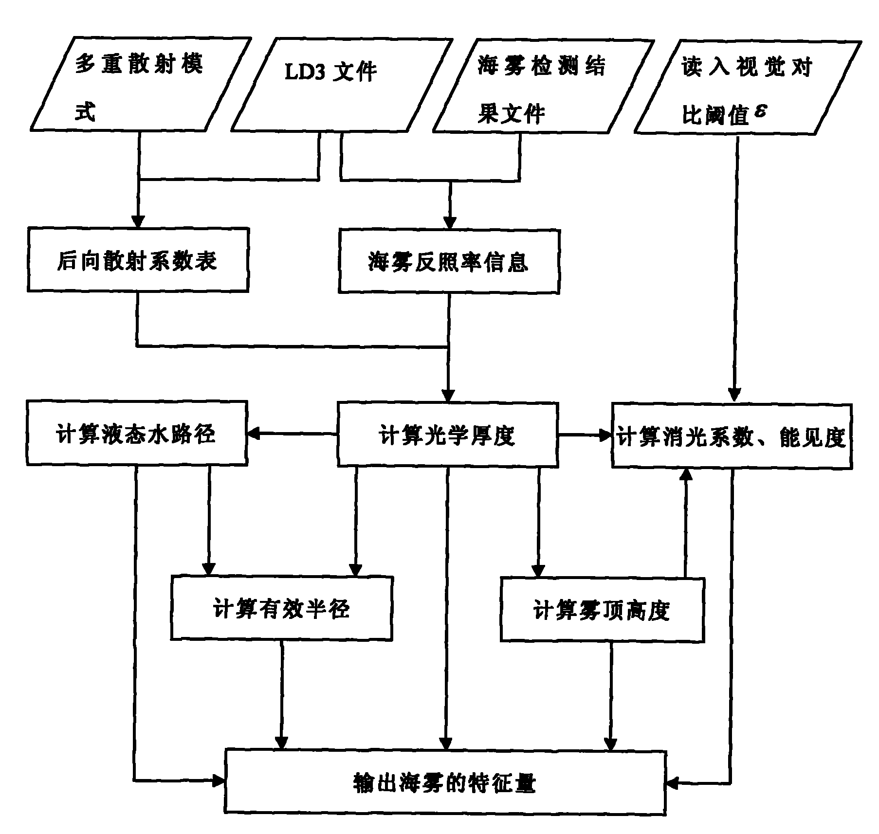
However, the existing technology does not separate the fog from the low cloud, and essentially does not invert the characteristic quantity of the sea fog, and the change of the characteristic quantity of the sea fog is related to the generation and disappearance of the sea fog. According to the optical thickness of the sea fog, the effective radius and the liquid water The change of content can provide an important basis for sea fog dissipation forecast
However, if the sea fog is not distinguished from the low cloud, strictly speaking, the feature quantity of the sea fog cannot be extracted, and it is impossible to provide information for the prediction of sea fog dissipation.
Method used
Image
Click on the blue label to locate the original text in one second.
Reading with bidirectional positioning of images and text.
Examples
Embodiment Construction
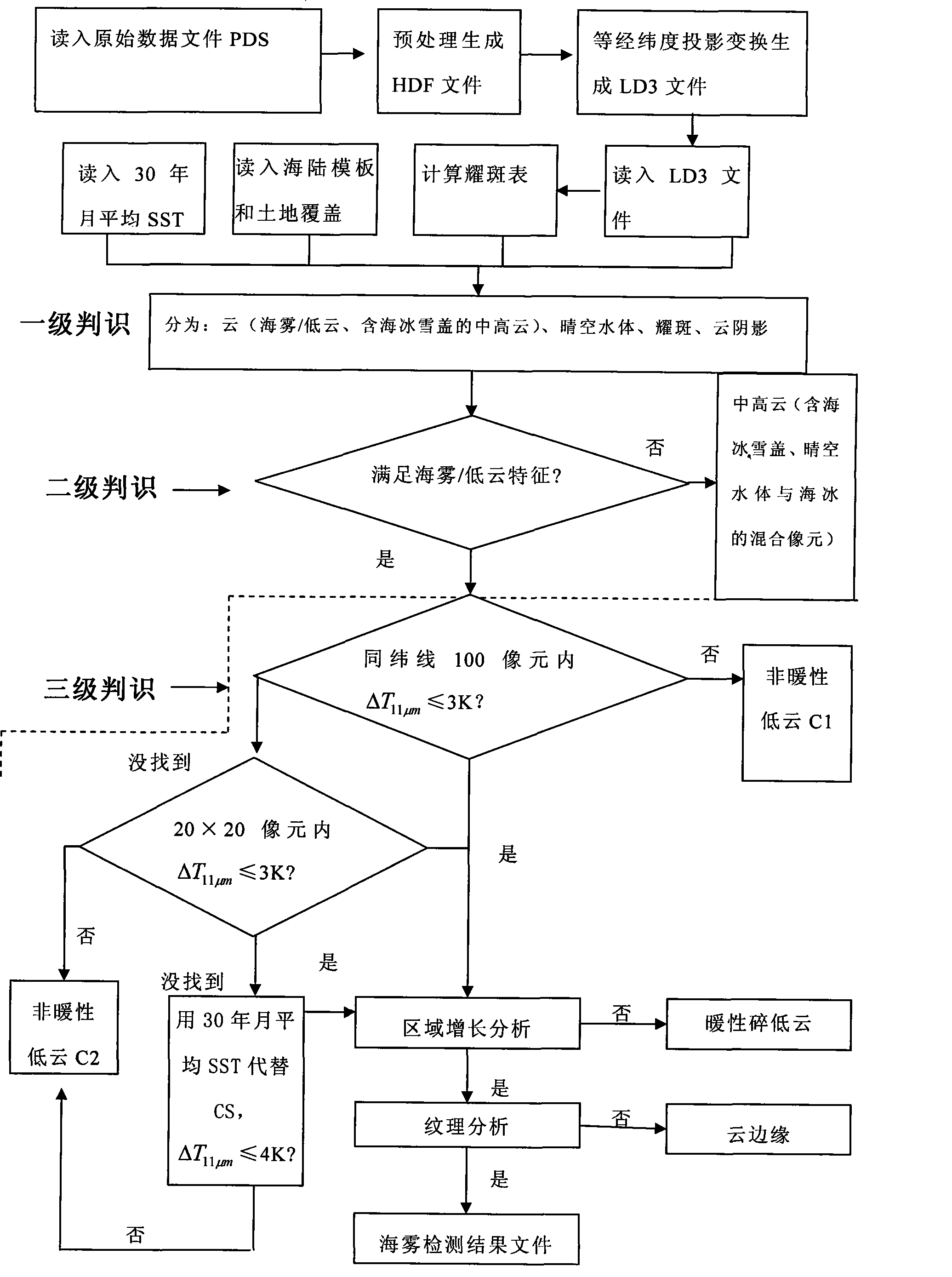
[0010] like figure 1 , the concrete steps of the present invention are as follows:
[0011] 1) The data acquisition is obtained and read into the PDS file through the polar-orbiting satellite digital visual broadcasting system (DVBS).
[0012] 2) Read in the solar zenith angle, solar azimuth angle, satellite zenith angle, satellite azimuth angle, geographic positioning data, and calibration data parameters from the header file of the PDS data set file, and use conventional methods to perform data pre-processing on the PDS file. Processing and quality control (streak removal, data scaling and positioning, etc.). HDF files are generated after preprocessing and quality control; then the HDF files are geometrically fine-corrected using a common method to generate a local equilateral longitude and latitude projection data file LD3, which includes the sun zenith angle, satellite zenith angle and sun satellite Relative azimuth information and spectral data information of each chann...
PUM
Abstract
The invention relates to a real-time extracting method of satellite remote sensing sea fog characteristic quantity, daytime EOS / MODIS data is used and is read into a raw data file PDS, the difference of sea fog and low cloud on a spectral characteristic is analyzed in two steps that: firstly, the sea fog and the low cloud are separated, and then, the sea fog characteristic quantity is extracted, namely that a three-level identifying method is adopted to orderly filter high cloud, middle cloud, low cloud, a cloudless water body, a solar flare water body, a cloud shadow area, a sea ice and a snow cover, the sea fog detection is established, a sea fog distributing area is obtained, a file which comprises a sea fog detecting result is generated, then, the sea fog characteristic quantity of the optical thickness of a fog area, the effective radius of fog and a liquid water path are calculated according to a formula, and pictures are displayed on a microcomputer. The method not only extracts the sea fog characteristic quantity, but also can calculate the visibility and the fog top height of the fog, consequently, the quantification detection of the sea fog is realized, and a dissipationforecast of the sea fog supplies meteorological information for air safety above the sea, maritime traffic and coastal airport operation.
Description
technical field [0001] The invention belongs to marine environment monitoring technology, in particular to a method for real-time extraction of satellite remote sensing sea fog feature quantities. Background technique [0002] Sea fog is a common weather phenomenon in my country's coastal waters. When there is sea fog, water vapor condensation produces a large number of fog droplets suspended above the sea surface, and the scattering and reflection of fog droplets reduce the visibility of the sea surface, which has an important impact on human sea activities. [0003] Existing studies have shown that foreign literature reports use channels 1, 3 and 4 of the AVHRR (Very High Resolution Radiometer) of NOAA satellites to invert satellite remote sensing data to obtain fog and low clouds with a certain spatial generality (following Abbreviated as the feature quantity of fog / low cloud): fog / low cloud cloud droplet effective radius r e , optical thickness τ, liquid water path LWP...
Claims
Application Information
Patent Timeline
Application Date:The date an application was filed.
Publication Date:The date a patent or application was officially published.
First Publication Date:The earliest publication date of a patent with the same application number.
Issue Date:Publication date of the patent grant document.
PCT Entry Date:The Entry date of PCT National Phase.
Estimated Expiry Date:The statutory expiry date of a patent right according to the Patent Law, and it is the longest term of protection that the patent right can achieve without the termination of the patent right due to other reasons(Term extension factor has been taken into account ).
Invalid Date:Actual expiry date is based on effective date or publication date of legal transaction data of invalid patent.
