Emergency device based on satellite navigation system

A satellite navigation system and emergency device technology, applied in traffic control systems, road network navigators, beacon systems using radio waves, etc., can solve problems such as vehicle failures and traffic accidents

Inactive Publication Date: 2009-06-24
向阳同行投资咨询(武汉)有限公司
View PDF0 Cites 4 Cited by
  • Summary
  • Abstract
  • Description
  • Claims
  • Application Information

AI Technical Summary

Problems solved by technology

However, the driver user is often not so smooth on the road, and the driver may encounter one or another problem, such as traffic accidents, serious traffic jams, or abnormal situations such as vehicle failures.
When an abnormal situation occurs during the driving of the car, the driver is usually caught off guard and does no

Method used


Image

  • Emergency device based on satellite navigation system
  • Emergency device based on satellite navigation system
  • Emergency device based on satellite navigation system

Examples


Embodiment

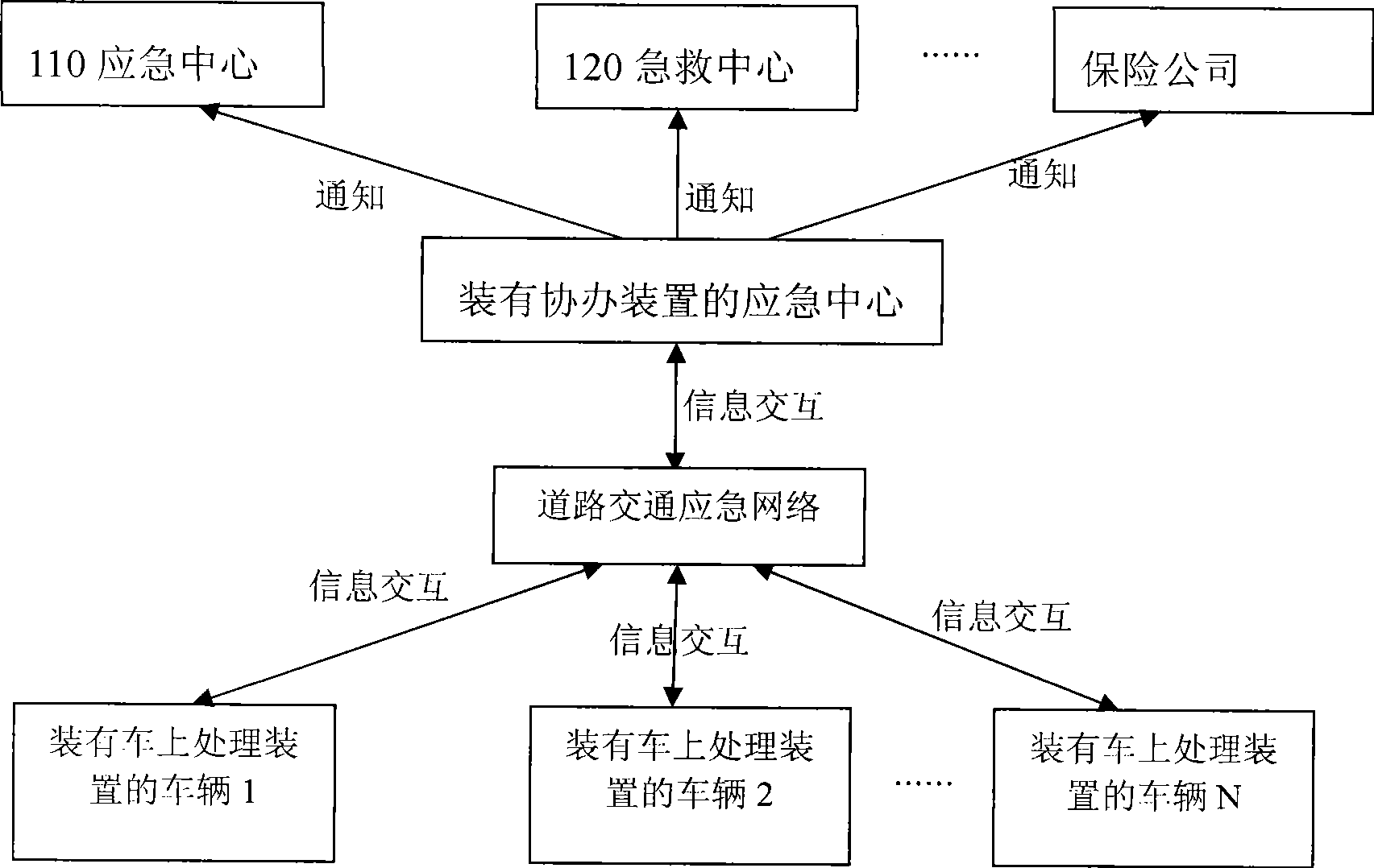
[0030] Such as image 3 As shown, the present invention integrates the original vehicle 1, vehicle 2 ... vehicle N (N is a natural number) and a single emergency center through the above-mentioned emergency device based on the satellite navigation system to form a road traffic emergency network.

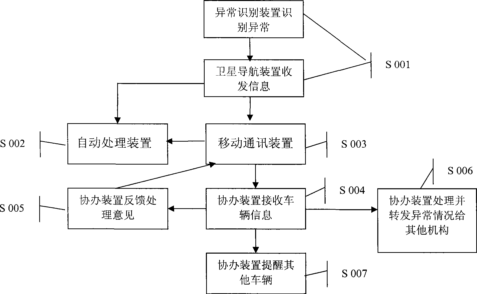
[0031] Combine below figure 2 , briefly describe the process of handling the abnormal situation of the vehicle and the emergency center installed with the emergency device of the present invention in sequence.

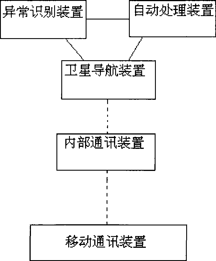
[0032] In step S001, the abnormality recognition device mainly consists of a vehicle camera and an image recognition module. The on-board camera can capture detailed image information in the car and in front of the car. The image recognition module judges whether the vehicle is abnormal according to the captured image information. If an abnormality occurs, the captured image information and the basic vehicle information obtained by the satellite navigation device are sent t...


PUM


Abstract

The invention relates to a satellite navigation-based emergency device capable for dealing with the abnormal conditions of road traffic. The emergency device comprises an on-board processing device and an auxiliary device position in an emergency center, wherein, the on-board processing device comprises a satellite navigation device, a mobile communication device, an abnormal recognition device, an interior communication device and an automatic processing device which are connected through data interfaces; the auxiliary device is used for receiving, handling and sending the abnormal conditions of the vehicle; and the emergency device enables the vehicle and the emergency center to form a road traffic emergency network. The device enables the emergency information to be shared under the traffic emergency network built by the on-board processing device as well as the emergency center processing device so that people can face the abnormal conditions of the road traffic together. When an abnormal circumstance occurs during the driving process of the vehicle, not only the abnormal conditions can be automatically handled, but also the emergency center is informed of help obtained from the emergency center through the device, and the abnormal conditions can be forwarded to other vehicles through the emergency center to remind the other drivers to pay more attention to the traffic safety.

Description

technical field [0001] The invention relates to a navigation device, in particular to an emergency device for a car satellite navigation system. Background technique [0002] The satellite navigation system includes two major components: one is the Global Positioning System (Global Positioning System, referred to as GPS). This system consists of three independent parts: space part, ground support system and user equipment. The global positioning system has the characteristics of good performance, high precision and wide application. It is the best navigation and positioning system so far. With the continuous improvement of the global positioning system, the continuous improvement of hardware and software, the application field is constantly being developed, and it has spread to various sectors of the national economy, and has gradually penetrated into people's daily life. The second is the navigation software, which calculates the user's spatial position, direction and mov...

Claims


Application Information

Patent Timeline
IPC IPC(8): G08G1/00G08G1/133G08G1/09G08G1/0965G01S1/08G01C21/34
Inventor 党魁刘泽民
Owner 向阳同行投资咨询(武汉)有限公司
Why Eureka
Try Eureka