Road network modeling method based on road element

A modeling method and road technology, applied in the traffic control system of road vehicles, special data processing applications, instruments, etc., can solve the problem of increasing the amount of physical model data, reducing the efficiency of model space search, increasing the complexity of road network models, etc. problem, to achieve the effect of simplifying the complexity, facilitating the space model, and stabilizing the solution process

Inactive Publication Date: 2009-07-22
TONGJI UNIV
View PDF2 Cites 33 Cited by
  • Summary
  • Abstract
  • Description
  • Claims
  • Application Information

AI Technical Summary

Problems solved by technology

The model construction method not only increases the complexity of the road network model, increases the data volume of the physical model, but also reduces the space search efficiency of the model, which fundamentally affects the operation efficiency of the intelligent transportation system

Method used


Image

  • Road network modeling method based on road element
  • Road network modeling method based on road element
  • Road network modeling method based on road element

Examples


Embodiment Construction

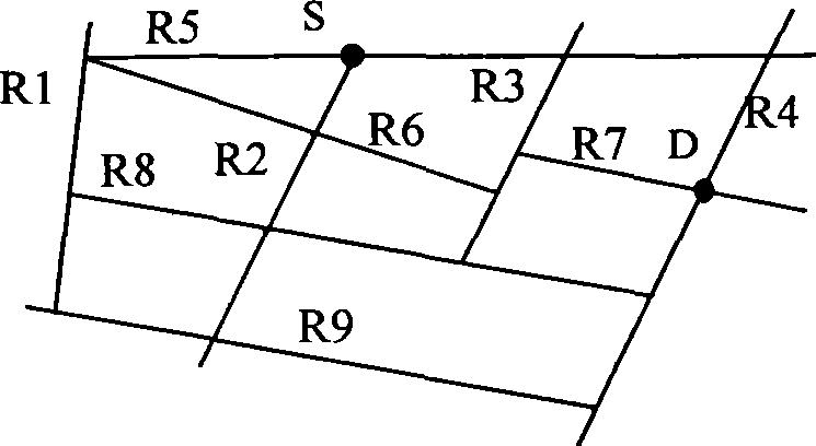
[0045] Please see attached figure 1 As shown, it is a small road network containing 9 roads and 15 intersections. The basic data in the RB model can be expressed as a data table as shown in Table 1, in which the first column is the road, called M road; Two columns are the source point O of the M road shown in the first column; The third column begins to be the road intersecting with the M road shown in the first column, called Li road (i=1, 2, ...); The last valid data is the end point E of the M paths shown in the first column. In fact, the Li road in Table 1 represents the intersection formed by the intersection with the M road. The closer the Li road that intersects with the same M road is to the source point O of the M road, the closer the record in Table 1 is to O. If there are two or more roads, such as Li road and Lj road intersecting with the same M road at the same intersection, the sequence of Li road and Lj road appearing in the table will not be affected.

[004...


PUM


Abstract

The invention provides a road network modeling method which takes road as a fundamental element, aiming at describing a traffic network by utilizing mutual relation among the roads with substitutive characteristics of the road in the traffic network taken into account. A data model matched with a conceptual model is given on the basis of improving a road network model which takes the road as the fundamental element, and data redundancy is reduced by blending related traffic information. A path searching algorithm suitable for the road network model is proposed on the basis of the road network model, and the path searching optimization is realized by utilizing road relation and road traffic attribute.

Description

technical field [0001] The invention relates to an original model of path planning series in the field of intelligent transportation, and a road network model establishment method supporting path traffic information query and optimal path search. Background technique [0002] The traffic road network mainly includes two parts of information, which are spatial information and traffic information. Spatial information mainly includes the spatial position information of each object on the road network, and the topological relationship between these objects. Objects on the traffic road network mainly include roads, traffic intersections, and various factories, communities, gas stations and other entities; among them, factories and communities belong to "surface" objects, roads belong to "line" objects, and other locations such as traffic intersections belong to "points". " object. Traffic information is the landmark information on the traffic road network and the essential char...

Claims


Application Information

Patent Timeline
Patent Type & Authority Applications(China)
IPC IPC(8): G06F17/50G08G1/00
Inventor 乔非王遵彤王文峰葛雷
Owner TONGJI UNIV
Why Eureka
Try Eureka