GIS middleware collocation and management method

A technology of configuration management and middleware, which is applied in the field of geographic information systems, can solve problems such as limiting software scalability and wasting manpower and material resources, and achieve the effect of avoiding data format conversion information loss and strong scalability

Active Publication Date: 2009-07-29
武汉中地数码科技有限公司 +1
View PDF0 Cites 18 Cited by
  • Summary
  • Abstract
  • Description
  • Claims
  • Application Information

AI Technical Summary

Problems solved by technology

However, for each data format to be directly accessed, the client software must write its read-write driver, so direct data access must fully understand the data format of the host software
If the data format of the host software is not disclosed, or the data format changes, the client software will have to

Method used


Image

  • GIS middleware collocation and management method
  • GIS middleware collocation and management method
  • GIS middleware collocation and management method

Examples


Example Embodiment

[0035] Specific implementation plan

[0036] The embodiments of the present invention will be further described below in conjunction with the accompanying drawings.
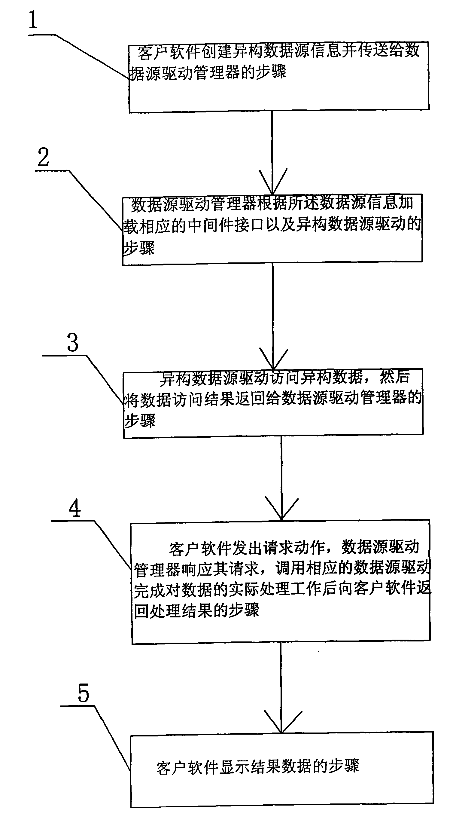
[0037] figure 1 It is a schematic diagram of the GIS middleware configuration management method flow, such as figure 1 As shown, a GIS middleware configuration management method, its steps are as follows:

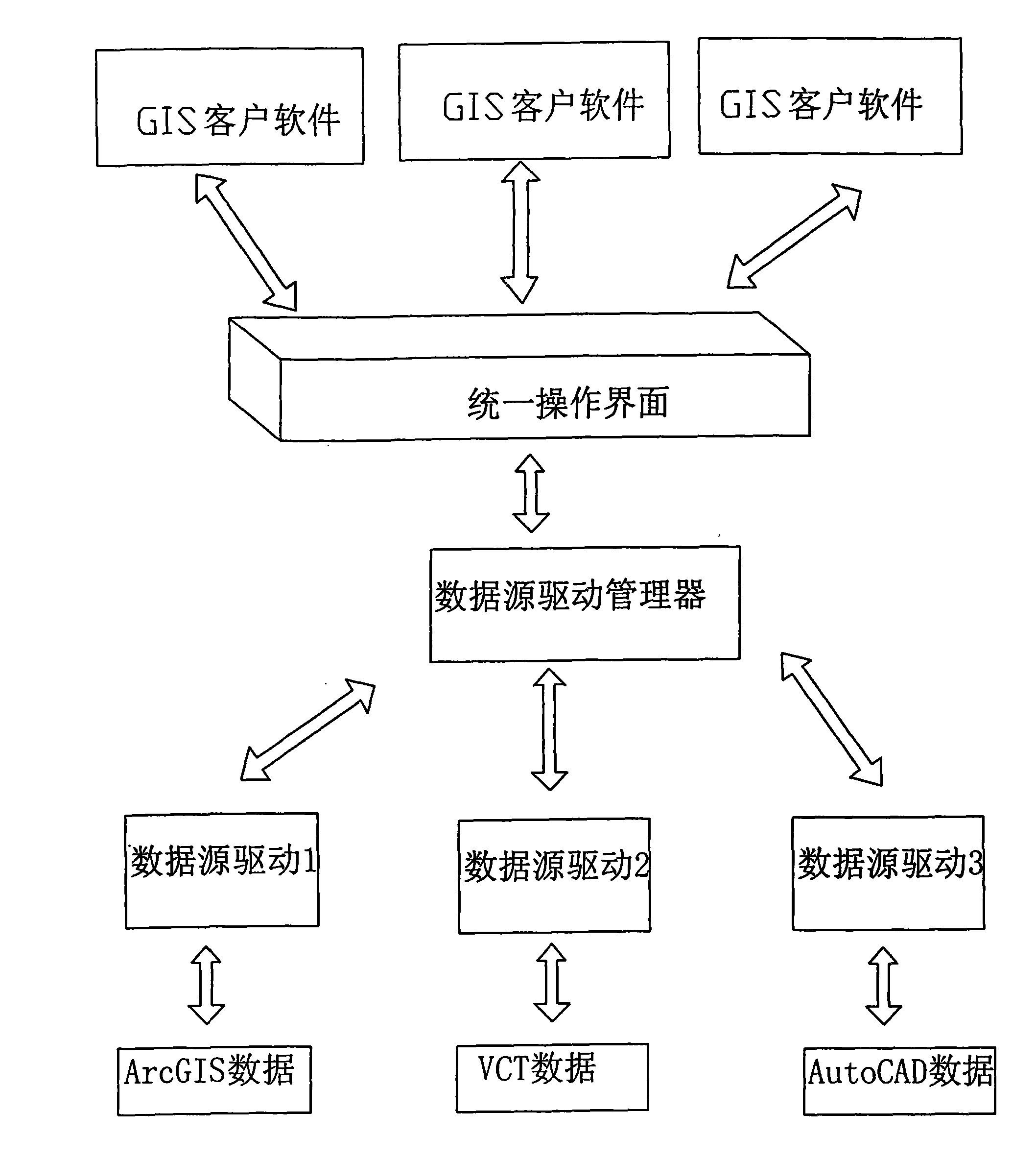
[0038] 1), the client software creates heterogeneous data source information and transmits it to the data source driver manager; such as

[0039] 2) The data source driver manager loads the corresponding middleware interface and the heterogeneous data source driver according to the heterogeneous data source information; for example, if the heterogeneous data source is ArcGIS Shapefile file data, the heterogeneous data source object Transfer to the Shapefile driver;

[0040] 3) The heterogeneous data source driver in the step 2) directly accesses the heterogeneous data source, and then returns the successful acc...


PUM


Abstract

The invention relates to a geographic information system, in particular a configuration management method for a GIS middleware, which has the following steps: (1) client software creates heterogeneous data resource information and sends the information to a data resource drive manager; (2) the data resource drive manager loads a corresponding middleware interface and heterogeneous data resource drive according to the heterogeneous data resource information; (3) the heterogeneous data resource drive in Step 2 directly visits the heterogeneous data resource and returns successful visit information to the data resource drive manager, and then the data resource and corresponding data resource drive are connected successfully; (4) the client software sends out request action, the data resource drive manager responses to the request and calls corresponding data resource drive to finish the actual processing work of the data then and returns the processed result to the client software; and (5) the client software displays the result data. The configuration management method can realize multi-source data integration without frequent data format conversion or large quantity of repetitive work.

Description

technical field [0001] The invention relates to a geographic information system, in particular to a GIS middleware configuration management method. Background technique [0002] At present, there are mainly three modes for the integration of GIS multi-source spatial data: one is spatial data exchange, which constrains and standardizes various existing geographic information systems by establishing a unified data exchange standard, and uses data exchange standards to exchange spatial data; The first is the data interoperability mode, which establishes an open geographic data interoperability specification and performs geographic information system interoperability; the third is the direct operation mode, which implements direct access, storage and spatial analysis of other software data formats in one GIS software. [0003] The above three integration modes have the following disadvantages: [0004] The data exchange mode is to convert data in other formats into the data for...

Claims


Application Information

Patent Timeline
IPC IPC(8): G06F17/30
Inventor 吴信才谢忠吴亮
Owner 武汉中地数码科技有限公司
Why Eureka
Try Eureka