Nighttime imaging cloud-height measuring method

A measurement method and imaging technology, applied in the direction of measuring device, line-of-sight measurement, distance measurement, etc., to achieve the effects of low price, accurate measurement results, and simple equipment structure

Inactive Publication Date: 2009-09-23
CMA METEOROLOGICAL OBSERVATION CENT
View PDF0 Cites 5 Cited by
  • Summary
  • Abstract
  • Description
  • Claims
  • Application Information

AI Technical Summary

Problems solved by technology

[0003] The invention provides a nighttime imaging cloud height measurement method, to solve the technical problem of measuring cloud height with a lower cost and simpler method

Method used


Image

  • Nighttime imaging cloud-height measuring method
  • Nighttime imaging cloud-height measuring method

Examples


Embodiment Construction

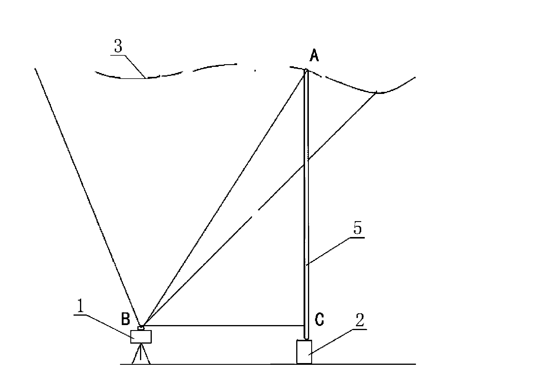
[0019] Examples see figure 1 , figure 2 , this night imaging cloud height measurement method, the steps are:

[0020] Step 1: Set up an image collector 1 and a laser light source 2 at a certain distance, and make the optical axis of the lens of the image collector 1 and the optical axis of the laser light source 2 perpendicular to the horizontal plane.

[0021] Step 2: Turn on the laser light source 2, and use the image collector 1 to collect the imaging plane 4 of the laser beam 5 at the same time.

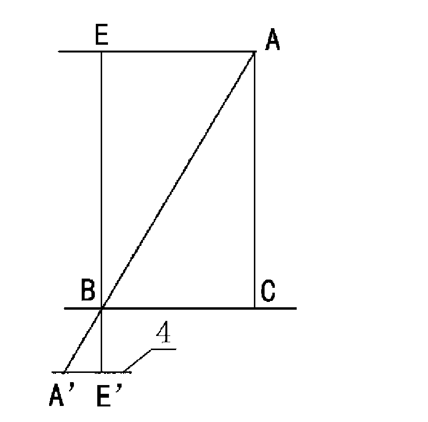
[0022] Step 3: Select the focal point of the image collector 1 as B, the emission point of the laser light source 2 as C, and the vertex of the laser beam as A. Take a point E on the optical axis of the lens of the image collector 1, so that the distance from point A to point E is The line segment is parallel to the line segment from point B to point C, find the projection point A' of point A on the imaging plane and the projection point E' of point E on the imaging plane on t...


PUM


Abstract

A nighttime imaging cloud-height measuring method comprises the steps of: 1. arranging an image collector and a laser source respectively at a certain interval and leading lens optical axis of the image collector and optical axis of the laser source to be vertical to the horizontal plane; 2. opening the laser source and simultaneously adopting the image collector to collect imaging plane of a laser beam; 3. respectively selecting the focus of the image collector as B, the launching point of the laser source as C and the top point of laser beam as A; and selecting one point on the lens optical axis of the image collector as E and leading the line section between the point A and the point E to be parallel with the line section between the point B and the point C; and respectively finding subpoint A' of point A and subpoint E' of E on the imaging plane and measuring the distance A'E' between the subpoint A' and the subpoint E'; and 4. calculating cloud-height according to a formula: AC equals E'B multiplied by BC / A'E'. The method has the advantages of simple measuring steps and accurate measuring result. The nighttime imaging cloud-height measuring method can solve the cloud-height measurement with lower cost and is applicable to cloud-height measurement of various cloud layers.

Description

technical field [0001] The invention relates to a method for measuring cloud height, in particular to a method for measuring cloud height at night. Background technique [0002] Cloud height is the vertical distance from the cloud base to the ground. The measurement of cloud height is of great significance to the field of aerospace, and it is an important reference data for spacecraft launch. Traditional cloud height measurement devices include cloud curtain lamps, infrared cloud measuring instruments, laser cloud measuring instruments, etc. Among them, the cloud curtain lamp can only be applied to the measurement of cloud height of stratiform clouds, which has great limitations. The advantage of the laser cloud meter is high accuracy, fast and convenient to use, but the disadvantage is that it is expensive and can only measure the cloud height of a single point in the sky. The method of using infrared to measure cloud height is to use infrared measuring device to measure...

Claims


Application Information

Patent Timeline
Patent Type & Authority Applications(China)
IPC IPC(8): G01C3/20
Inventor 马舒庆
Owner CMA METEOROLOGICAL OBSERVATION CENT
Why Eureka
Try Eureka