Remote sensing land use change detection method and system thereof

A technology of change detection and land use in the field of remote sensing detection, which can solve the problems that change detection cannot be realized, the degree of automation is low, and the spatial feature information of adjacent pixels is not fully considered, so as to achieve real-time remote sensing land use change detection and improve accuracy. Effect

Active Publication Date: 2010-03-03
NONGXIN TECH BEIJING CO LTD
View PDF0 Cites 38 Cited by
  • Summary
  • Abstract
  • Description
  • Claims
  • Application Information

AI Technical Summary

Problems solved by technology

[0003] The defect of the above-mentioned remote sensing detection method is that in the detection process, only the spectral feature information of the image is used, and the texture, shape, structure and other characteristic information contained in the image data are not fully utilized; , did not fully consider the spatial feature information between adjacent pixels; the land use type, geographic entity polygon position and other information hidden in the historical land thematic data were not fully utilized; manual interpretation was heavy workload, low degree of automation, easy Missing map spots; high requirements for data sources, requiring image data in different periods, when there is no image data in historical periods, change detection cannot be realized

Method used


Image

  • Remote sensing land use change detection method and system thereof
  • Remote sensing land use change detection method and system thereof
  • Remote sensing land use change detection method and system thereof

Examples


Embodiment Construction

[0032] Below in conjunction with accompanying drawing and embodiment, specific embodiment of the present invention is described in further detail

[0033] describe. The following examples are used to illustrate the present invention, but are not intended to limit the scope of the present invention.

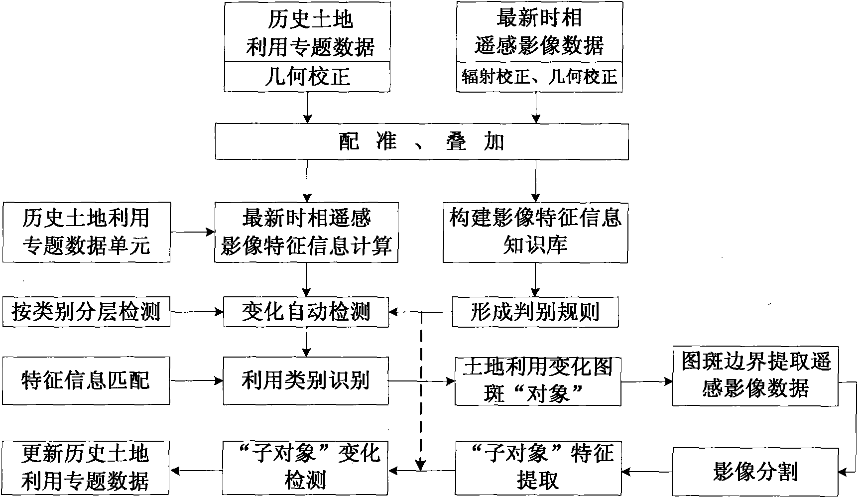
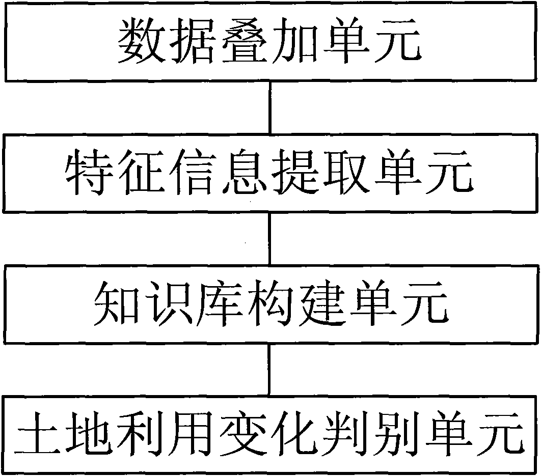
[0034] Such as figure 1 As shown, this embodiment provides a remote sensing land use change detection method. The detection method is specifically described as follows: firstly perform data superposition, correct the historical land use thematic data and the latest time phase remote sensing image data, and then perform geometric Registration, so that they have the same spatial and geographical coordinate information, and then realize the accurate superposition of vector data and raster data in the spatial position, and provide conditions for the accurate extraction of feature information oriented to the "pattern" object, where the map refers to the historical land Using the vect...


PUM


Abstract

The invention discloses a remote sensing land use change detection method comprising the steps of carrying out geometric registration to historical land use thematic data and latest time phase remotesensing image data and carrying out superposition on the space positions of the two kinds of data; taking the unchangeable unit in the historical land use thematic data as an object and extracting theimage feature information in the latest time phase remote sensing image data; constructing image feature information knowledge bases corresponding to different land use types by using the extracted image feature information; and forming judgement rules by using the image feature information knowledge bases according to the features of different land use types to judge whether the land use objectschange or not. The remote sensing land use change detection method can realize fast, accurate, real-time and object knowledge oriented remote sensing land use change detection.

Description

technical field [0001] The invention relates to the technical field of remote sensing detection, in particular to an automatic detection method and system for land use change which is oriented to land use 'pattern' objects and combines historical land use subject knowledge and latest phase remote sensing image information. Background technique [0002] With the continuous development of remote sensing technology, land use change detection using remote sensing image data has been widely used in actual production work. At present, the change detection methods are mainly divided into two categories: spectral type feature analysis method and spectral change vector analysis method. Among them, the spectral type feature analysis method mainly uses the spectral classification and calculation of remote sensing images in different phases to determine the distribution and type of change information, mainly including image difference method, image ratio method, image regression method,...

Claims


Application Information

Patent Timeline
Patent Type & Authority Applications(China)
IPC IPC(8): G06F17/30G06T7/00G01S7/48
Inventor 杨贵军黄文江李存军宋晓宇顾晓鹤杨小冬陈红
Owner NONGXIN TECH BEIJING CO LTD
Why Eureka
Try Eureka