System and method based on GPS for measuring farmland working area

A measurement method, GPS positioning technology, applied in the direction of measurement devices, information technology support systems, beacon systems using radio waves, etc., to achieve the effect of meeting the price, simple structure, and improving the accuracy of area measurement

Inactive Publication Date: 2011-07-06
JIANGSU UNIV
View PDF4 Cites 1 Cited by
  • Summary
  • Abstract
  • Description
  • Claims
  • Application Information

AI Technical Summary

Problems solved by technology

[0005] The purpose of the present invention is to overcome the above-mentioned deficiencies, and disclose a GPS-based farmland operating area measurement system and measurement method, which is characterized in that: a general GPS positioning system and a single-chip microcomputer are used to solve the problem of low GPS positioning accuracy and the regular shape of general farmland , by presetting or selecting the shape of the farmland, after going around the operation measurement area for a week, automatically recording the coordinates of the operation route, trimming the obtained farmland operation route, and converting the coordinates of the fixed point, and then calculating the surrounding area , so as to improve the measurement accuracy of farmland operation area

Method used


Image

  • System and method based on GPS for measuring farmland working area
  • System and method based on GPS for measuring farmland working area
  • System and method based on GPS for measuring farmland working area

Examples


Embodiment Construction

[0018] The present invention will be described in further detail below in conjunction with the accompanying drawings and specific embodiments.

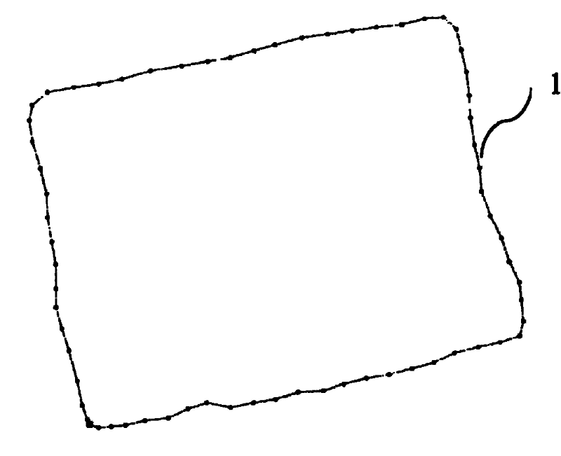
[0019] The GPS-based farmland operating area measurement system of the present invention adopts a general GPS positioning system and a single-chip microcomputer, and aims at the problem of low GPS positioning accuracy and the regular shape of the general farmland. By presetting or selecting the farmland shape, the GPS receiving module can Run the operation measurement area for a week, automatically record the coordinates of the operation route, trim the obtained farmland operation route, and convert the coordinates of the fixed point, and then calculate the surrounding area.

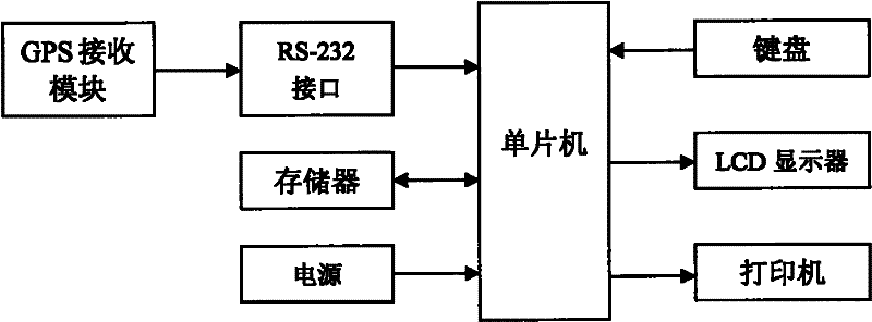
[0020] Such as figure 1 As shown, the GPS-based farmland operating area measurement system of the present invention includes a GPS receiving module, a single-chip microcomputer, a memory, a keyboard, an LCD display, a printer, and a power supply. The GPS receiv...


PUM


Abstract

The invention relates to a system based on GRS for measuring working areas. The system comprises a GPS receiving module, a single chip computer, a memory, a keyboard, a display, a printer and a power supply, wherein the GPS module receives a GPS satellite signal and inputs positioning information into the single chip computer by an RS232 serial port; the single chip computer processes the positioning information and calculates the area of the farmland; the memory stores a working record; by the keyboard and the display, the working fee-charging unit price is input, the date is set, the working route is trimmed, the working area is calculated, and the working record is searched; and the minitype printer prints and outputs the working record. The invention adopts a GPS positioning system tomeasure the working area of the original farmland, adopts the single chip computer to trim the working area of the original farmland and enhances the measurement accuracy of the working area of the farmland.

Description

technical field [0001] The invention relates to a GPS-based farmland operation area measurement system and a measurement method, which belong to the technical field of agricultural machinery testing and are mainly used for measuring the farmland operation area of ​​agricultural machinery to realize the valuation and management of farmland operations. Background technique [0002] Cross-regional operation of agricultural machinery such as combine harvesters is a form of farmland production operation suitable for my country's national conditions. When operating in different places, operators and farmers want to know the actual area and output of farmland operations. The allocation of area or output pricing system is an inevitable trend in the development of agricultural machinery. There is no delay. [0003] At present, there are mainly two methods for real-time detection of agricultural machinery operation area: one is to use GPS positioning system and area measuring instrumen...

Claims


Application Information

Patent Timeline
Patent Type & Authority Patents(China)
IPC IPC(8): G01B21/28G01D4/00G01S1/02
CPCY04S20/44Y04S20/30
Inventor 张西良陈进李萍萍李耀明董进泉张锋黄治根杨春松周毅华
Owner JIANGSU UNIV
Why Eureka
Try Eureka