Method for judging spatial position of target by linkage of multi-cameras and system thereof

A multi-camera, spatial location technology, applied in closed-circuit television systems, measuring devices, surveying and navigation, etc., can solve problems such as fuzzy monitoring

Inactive Publication Date: 2010-05-05
ZTE CORP
View PDF0 Cites 26 Cited by
  • Summary
  • Abstract
  • Description
  • Claims
  • Application Information

AI Technical Summary

Problems solved by technology

[0005] The technical problem to be solved by the present invention is to provide a method and system for judging the spatial position of the target through multi-camera linkage, solve the current problem of fuzzy monitoring, and achieve a three-dimensional grasp of on-site target information

Method used


Image

  • Method for judging spatial position of target by linkage of multi-cameras and system thereof
  • Method for judging spatial position of target by linkage of multi-cameras and system thereof
  • Method for judging spatial position of target by linkage of multi-cameras and system thereof

Examples


Embodiment Construction
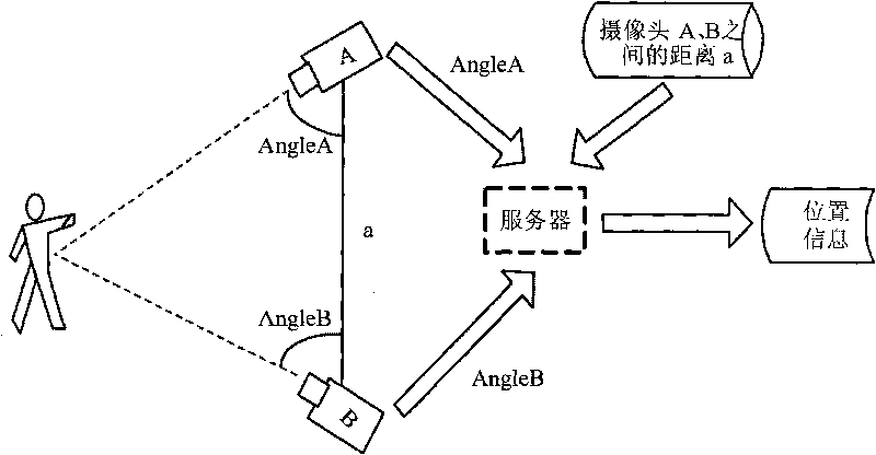
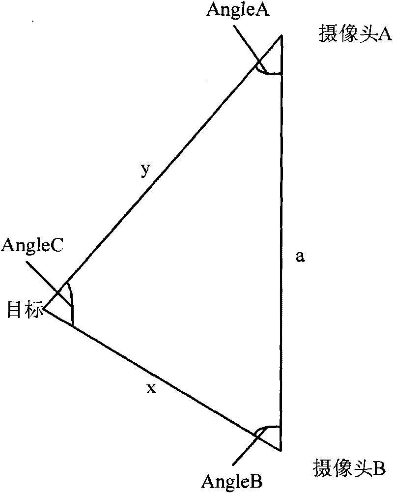
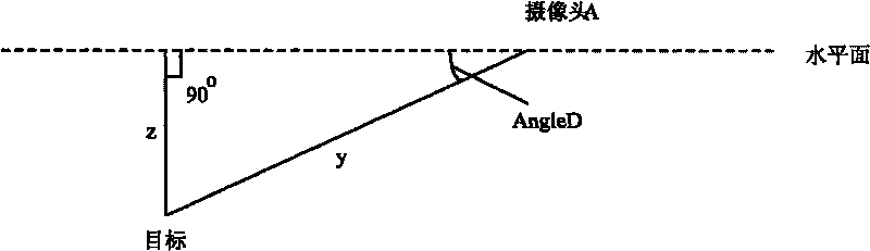
[0039] The main idea of ​​the present invention is by arranging at least two cameras, pre-storing the line distance between the cameras, aiming the cameras at the target (making the image in the center of the picture obtained by the cameras), and obtaining two relative distances between the target and the cameras respectively. The relative deflection angle of the line between the cameras, and the distance between the target and the line between the two cameras, so as to calculate the three-dimensional space position information of the target, including the straight-line distance of the target relative to the camera and the vertical distance of the target relative to the horizontal plane where the camera is located .

[0040] Preferred embodiments of the present invention will be described in detail below in conjunction with the accompanying drawings.

[0041] refer to figure 1 As shown in the figure, it is a deployment diagram of monitoring the environment through precise pos...


PUM


Abstract

The invention discloses a method for judging the spatial position of a target by the linkage of multi-cameras and a system thereof. The method comprises the steps of: putting at least two cameras at a monitoring environment and measuring the distance among each two cameras; aligning the cameras to a target to be monitored to obtain deflection angles of the two cameras to connecting liners therebetween; according to the distances and the deflection angles of the each two cameras, obtaining the practical distances from the target to the each camera; and according to the deflection angles of the practical distances from the target to the each camera and the connecting liners between the target and the cameras to the horizontal plane of the cameras, obtaining the vertical distances from the target to the horizontal plane of the cameras to obtain the three-dimensional spatial information of the target. Compared with the other monitoring methods, the method can accurately locate the three-dimensional position of the target be monitored in the monitoring environment to realize the accurate monitor.

Description

technical field [0001] The invention belongs to the technical field of video monitoring, and in particular relates to a method and a system for judging the spatial position of a target through multi-camera linkage. Background technique [0002] With the development of network technology and the continuous heating up of the security market, video surveillance, as an important field of security, has also made great progress. Video surveillance generally uses a camera as a front-end device to monitor the monitoring target, just like a human eye, which can see a wide range. [0003] However, just like the principle of human eye recognition, a single camera can only roughly observe the target in the coverage area, but cannot judge the position of the target from the monitoring point, and furthermore, it lacks spatial three-dimensional information. In this way, important clue information is likely to be missed in a complex scene, that is, only "fuzzy monitoring", which limits peo...

Claims


Application Information

Patent Timeline
Patent Type & Authority Applications(China)
IPC IPC(8): G01C3/10H04N7/18
Inventor 乔海荣
Owner ZTE CORP
Why Eureka
Try Eureka