Three-dimensional landmark selection and reference map preparation method for front-view navigation guidance

A landmark, three-dimensional technology, applied in the field of aircraft forward-looking navigation, can solve problems such as difficulties, the invisible and direct identification of navigation positioning points, the inability to survey and map the target and its adjacent areas on the spot, etc., to achieve the effect of improving intelligence

Active Publication Date: 2010-06-09
HUAZHONG UNIV OF SCI & TECH
View PDF0 Cites 18 Cited by
  • Summary
  • Abstract
  • Description
  • Claims
  • Application Information

AI Technical Summary

Problems solved by technology

The purpose is to provide data support and method basis for the navigation guidance problem of the aircraft's forward-looking indirect recognition and positioning destinati...

Method used


Image

  • Three-dimensional landmark selection and reference map preparation method for front-view navigation guidance
  • Three-dimensional landmark selection and reference map preparation method for front-view navigation guidance
  • Three-dimensional landmark selection and reference map preparation method for front-view navigation guidance

Examples


Embodiment Construction

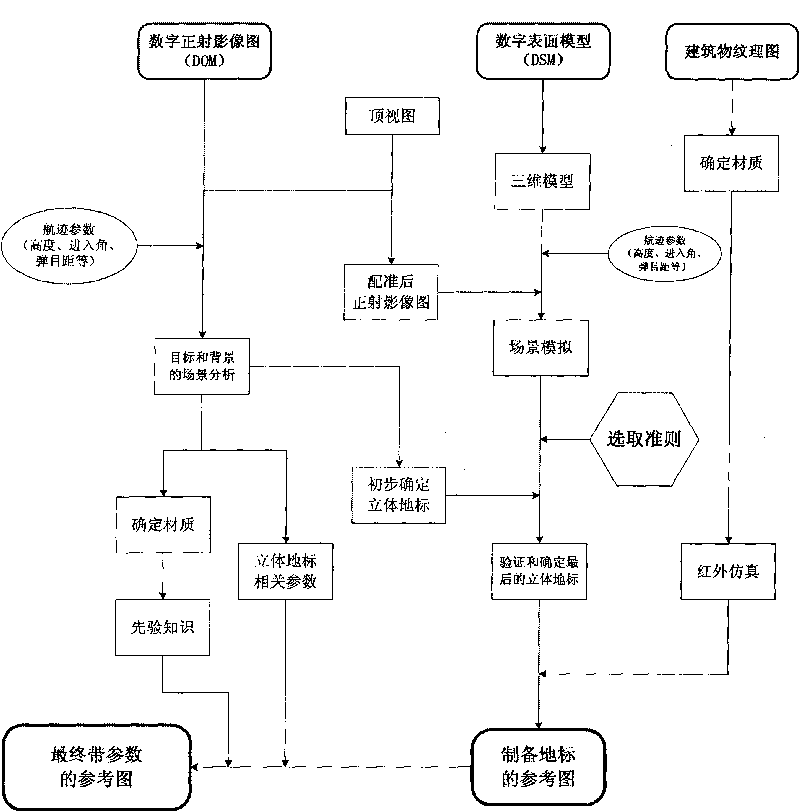
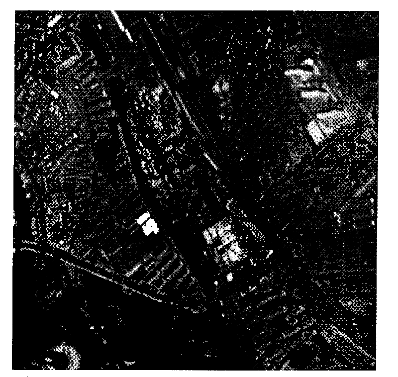
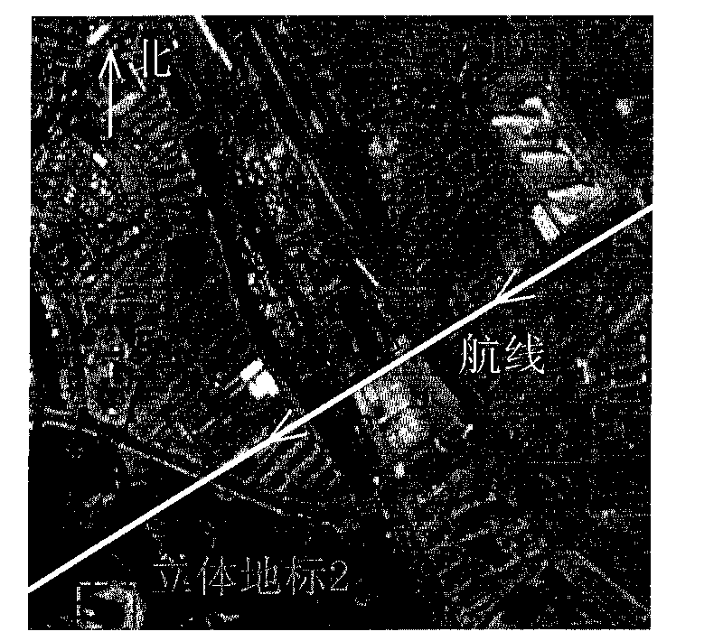
[0037] The present invention takes three-dimensional landmarks available on the aircraft's preset route as the implementation condition. figure 2 This is an example of a digital orthophoto map of a navigation destination area, with a resolution of 2.5 meters and a size of 800×800 pixels. Below to figure 2 A digital orthophoto image including a three-dimensional building, a river, a road, and land is taken as an example to further describe the present invention in detail. Such as image 3 As shown, in this example, the flight altitude of the aircraft is h=1000 meters, the entry angle is the angle α=243 degrees with the true north direction, and the horizontal field of view angle of the imaging sensor is degrees, the vertical field of view is φ degrees, the target position is marked with a solid line frame, and the three-dimensional landmark is marked with a broken line frame. overall process figure 1 As shown, specifically:

[0038] 1. Preliminarily determine the three-...


PUM


Abstract

The invention discloses a three-dimensional landmark selection and reference map preparation method for front-view navigation guidance of an aircraft, which specifically comprises the following steps: firstly carrying out scene analysis by combining preset track parameters and utilizing a digital orthophoto map (DOM), preliminarily determining the type of a target background material and three-dimensional landmarks which are possible to occur on a track, then utilizing a digital surface model (DSM) for simulating a flight scene on the present track, analyzing the blocking situation of a target and the three-dimensional landmarks, verifying and determining the three-dimensional landmarks used for navigation on the track according to the selection criteria of the three-dimensional landmarks, making a multi-view point and multi-scale optical feature map of the landmarks, calculating relevant parameters of all the landmarks and preparing a corresponding reference map with the parameters. The method can effectively select the three-dimensional landmarks required for navigation guidance according to reference data and prepare the reference map with the parameters under the situation that the flight destination is blocked or lack of significance, thereby providing effective navigation information and support guarantee for the navigation guidance.

Description

technical field [0001] The invention belongs to the technical field of forward-looking navigation guidance and imaging automatic target recognition of aircraft, and specifically relates to a method for selecting a three-dimensional landmark and preparing a reference map for forward-looking navigation guidance of an aircraft, using multiple data sources to select a three-dimensional landmark reasonably and correctly, Based on this, the reference map of the three-dimensional landmark is prepared to provide technical support for the target recognition algorithm, track planning and forward-looking navigation guidance. Background technique [0002] The automatic and accurate identification and positioning of ground navigation points in urban areas by unmanned aerial vehicles and manned aerial vehicles is a challenging problem with wide application value. [0003] Guo Wenpu, Sun Jiyin, Li Zhao et al. proposed a method for scene matching in the visible light band in "Preparation me...

Claims


Application Information

Patent Timeline
IPC IPC(8): G01C21/24
Inventor 张天序王岳环毛麟李成敖国庆杨效余万美君汪小平王登位孙思远郑璐璐王曼
Owner HUAZHONG UNIV OF SCI & TECH
Why Eureka
Try Eureka