
Monitoring method and system based on WEB GIS topological map

A GIS map and topological map technology, applied in the field of network geographic information system, can solve problems such as unintuitive, single presentation mode, and low timeliness, and achieve the effects of shortening processing time, improving work efficiency, and flexible use

Inactive Publication Date: 2010-06-09
ULTRAPOWER SOFTWARE
View PDF0 Cites 18 Cited by
  • Summary
  • Abstract
  • Description
  • Claims
  • Application Information

AI Technical Summary

Problems solved by technology

[0021] In the traditional monitoring system, the monitoring of equipment is separated, and it is not possible to conduct unified monitoring including various types of data that can be compared
And the presentation method is single, not intuitive
[0022] In the existing monitoring methods, it is impossible to focus on the monitoring of certain network element devices. For example, during a major meeting or important holiday, it is necessary to focus on monitoring some network element devices around the meeting place or around key areas. Real-time or quasi-real-time statistics and summary monitoring of the configuration, performance and alarm data of these network elements. In the traditional monitoring method, the operation and maintenance personnel can only search for relevant data in a lot of data, and then perform calculation and summary, which is not time-sensitive , unable to discover existing problems in time, and unable to provide leaders with the data needed for command and decision-making in a timely manner

Method used


Image

  • Monitoring method and system based on WEB GIS topological map
  • Monitoring method and system based on WEB GIS topological map
  • Monitoring method and system based on WEB GIS topological map

Examples


Embodiment Construction

[0061] The specific implementation manners of the present invention will be further described in detail below in conjunction with the accompanying drawings and embodiments. The following examples are used to illustrate the present invention, but are not intended to limit the scope of the present invention.

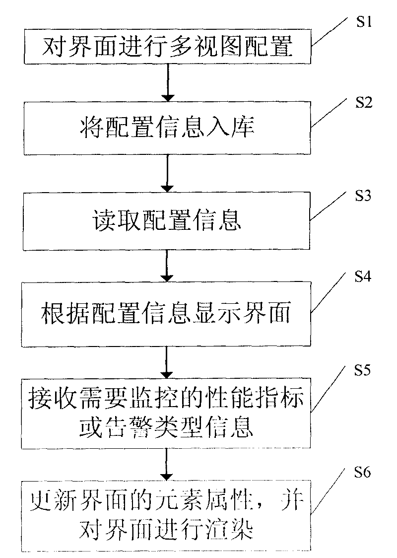
[0062] According to the monitoring method based on WEB GIS topological map of the embodiment of the present invention, the method comprises the following steps:

[0063] S1, performing multi-view configuration on the interface;

[0064] S2, storing the configuration information into the database;

[0065] S3, read configuration information;

[0066] S4, displaying an interface according to the configuration information;

[0067] S5, receiving performance indicators or alarm type information to be monitored;

[0068] S6. Update element attributes of the interface according to the performance index or alarm type information, and render the interface.

[0069] The config...


PUM


Abstract

The invention discloses a monitoring method and a system based on a WEB GIS topological map. The method comprises the following steps: carrying out multi-view configuration on an interface; putting the configuration information in storage; reading the configuration information; displaying the interface according to the configuration information; receiving performance indexes or alarm type information needing to be monitored; updating element attribution of the interface according to the performance indexes or the alarm type information; and rendering the interface. The technical scheme of the invention can provide an intuitive, multi-faceted and full angular monitoring scheme having significance to monitoring personnel.

Description

technical field [0001] The present invention relates to the field of network geographic information systems, in particular to a monitoring method and system based on WEB GIS (Web Geographical Information System, network geographic information system) topology map. Background technique [0002] In the field of traditional network management and monitoring, device monitoring mainly includes configuration management, performance management and alarm management. [0003] Configuration management refers to the resource system. Resource management mainly reflects the allocation of various types of equipment resources and the setting of important parameters in the province's mobile network. It can easily understand the allocation and use of key resources and count the resources of the entire network. , in order to strengthen management and maximize the benefits of telecommunications network resources. Including configuration entry and management functions. [0004] Performance ma...

Claims


Application Information

Patent Timeline
IPC IPC(8): H04L12/24
Inventor 杨国良刘威李宏琳刘宇龙
Owner ULTRAPOWER SOFTWARE
Learn More