Road network monitoring system based on satellite communication positioning and wireless electronic tag technology

A technology of wireless electronics and satellite communication, applied in satellite radio beacon positioning system, radio wave measurement system, radio transmission system and other directions, can solve the problem of vehicle safety not being fully guaranteed.

Inactive Publication Date: 2010-06-23
CHENGDU LINHAI ELECTRONICS
View PDF0 Cites 7 Cited by
  • Summary
  • Abstract
  • Description
  • Claims
  • Application Information

AI Technical Summary

Problems solved by technology

It is partial and hysteresis, and there is no complete guarantee for the vehicle safety of the expressway network

Method used


Image

  • Road network monitoring system based on satellite communication positioning and wireless electronic tag technology
  • Road network monitoring system based on satellite communication positioning and wireless electronic tag technology

Examples


Embodiment Construction

[0015] All features disclosed in this specification, or steps in all methods or processes disclosed, may be combined in any manner, except for mutually exclusive features and / or steps.

[0016] Any feature disclosed in this specification (including any appended claims, abstract and drawings), unless expressly stated otherwise, may be replaced by alternative features which are equivalent or serve a similar purpose. That is, unless expressly stated otherwise, each feature is one example only of a series of equivalent or similar features.

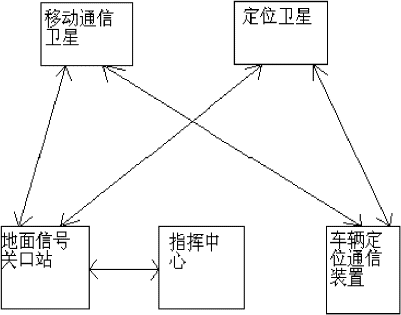
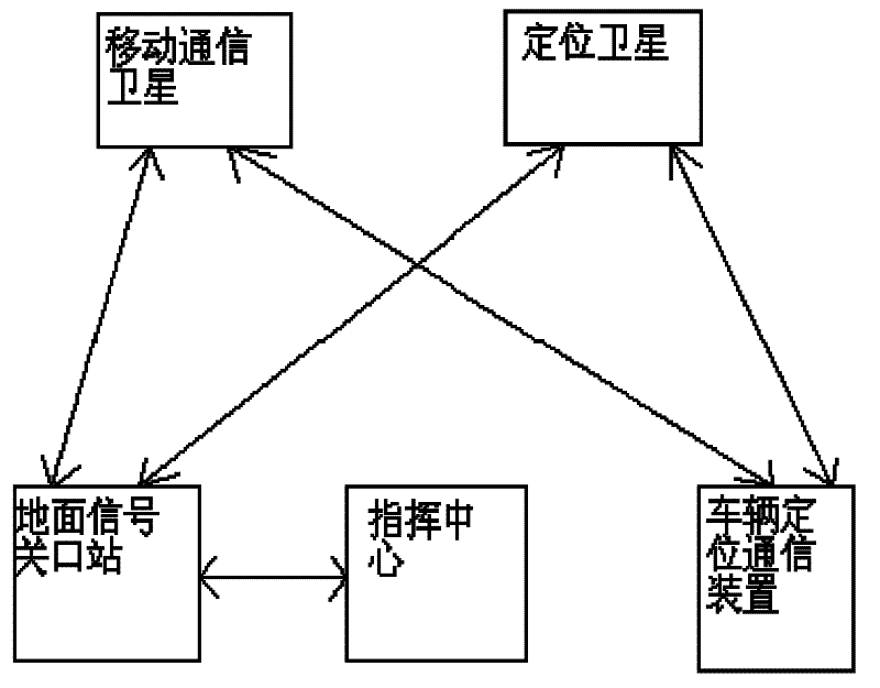
[0017] The road network monitoring system based on satellite communication positioning and wireless electronic tag technology in this embodiment includes two parts, the space segment and the ground segment, wherein the space segment is composed of two types of satellites, which are respectively mobile communication satellites and positioning satellites, and the positioning satellites acquire ground For the location information of vehicles driv...


PUM


Abstract

A road network monitoring system based on satellite communication positioning and wireless electronic tag technology includes a space section and a road surface section; wherein, the space section is composed of two types of satellites, including a mobile communication satellite and a positioning satellite, the positioning satellite is used for acquiring the position information of a vehicle in a highway, and the mobile communication satellite realizes the communication between a vehicle in the highway and a command center; the road surface section is composed of a ground signal terminal station for supporting the positioning satellite and the mobile communication satellite, a command center and a vehicle positioning communication device, the ground signal terminal station receives and transmits the signals of the two types of satellites, and establishes network communication connection with the command center, and the vehicle positioning communication device is composed of a position indicator, a satellite mobile phone terminal and a wireless electronic tag. By adopting the road network monitoring system and for the vehicles in a highway, the command center can obtain the vehicle information and position information in real-time and can establish speech communication with each vehicle in certain road section, and carry out rescue in time.

Description

technical field [0001] The invention relates to the field of expressway vehicle safety monitoring, in particular to a road network monitoring system based on satellite communication positioning and wireless electronic tag technology. Background technique [0002] At present, the safety monitoring of driving vehicles in the expressway network mainly relies on cameras and speed measuring devices installed on the expressway for image acquisition and speed monitoring; road safety is mainly maintained by the police on the road section. It is partial and hysteresis, and there is no complete guarantee for the vehicle safety of the expressway network. Contents of the invention [0003] The purpose of the present invention is to overcome the defects of the prior art, to provide a kind of vehicle information, location information for each vehicle on the highway, and to communicate with each vehicle based on satellite Communication positioning and wireless electronic label technolog...

Claims


Application Information

Patent Timeline
Patent Type & Authority Applications(China)
IPC IPC(8): G08G1/127G01S19/42H04B7/185
Inventor 刘铁华王小玲税成侠何戎辽倪国超王勇宋慧朱辉
Owner CHENGDU LINHAI ELECTRONICS
Why Eureka
Try Eureka