Navigation path planning method

A technology for navigating paths and paths, applied in directions such as road network navigators, can solve problems such as unavailability and unreasonable navigation paths, and achieve the effect of short estimated length

Active Publication Date: 2010-07-14
XIAMEN YAXON NETWORKS CO LTD
View PDF0 Cites 12 Cited by
  • Summary
  • Abstract
  • Description
  • Claims
  • Application Information

AI Technical Summary

Problems solved by technology

However, when users use the above navigation functions on a route that has formed a certain driving habit, they often cannot get pleasant results because the user artificially deviates from the route.
Because the machine has no subjective feelings, the navigation path it provides is correct from the perspective of the machine, but the navigation path is unreasonable from the perspective of humans

Method used


Image

  • Navigation path planning method
  • Navigation path planning method
  • Navigation path planning method

Examples


Embodiment 1

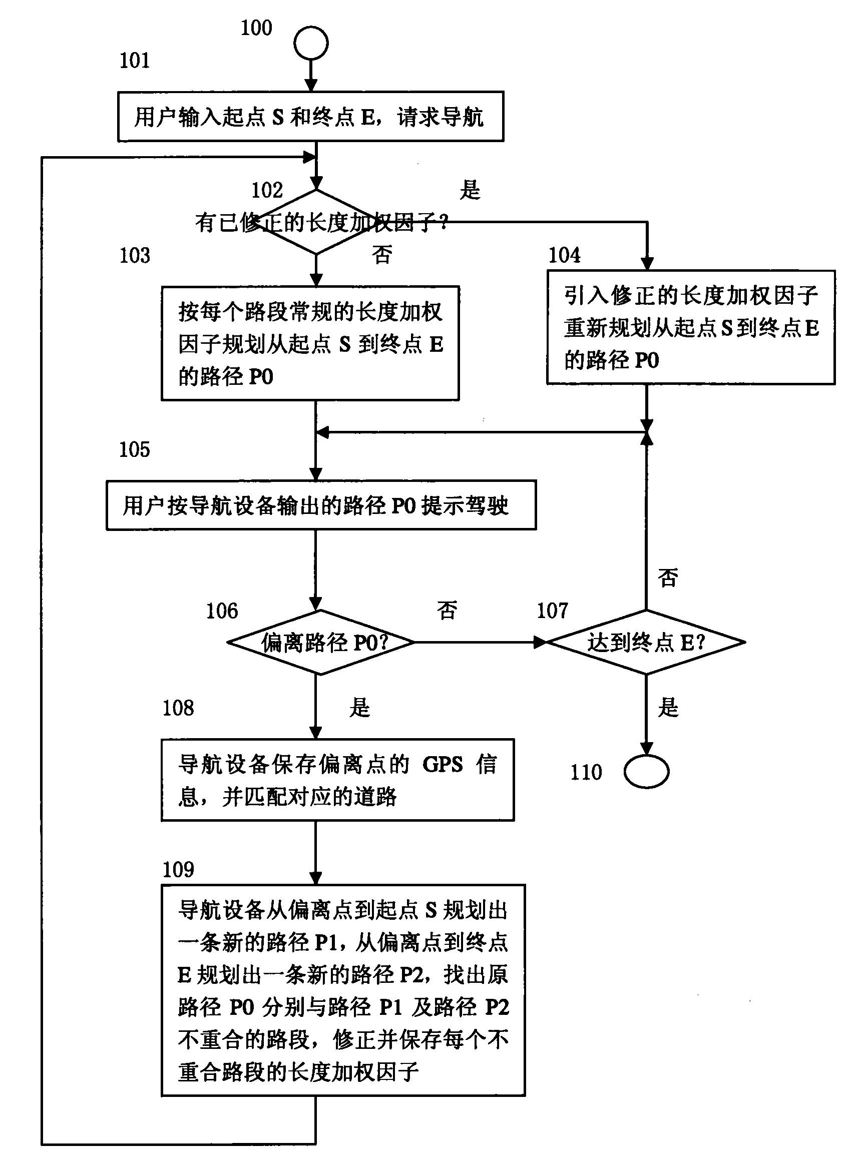
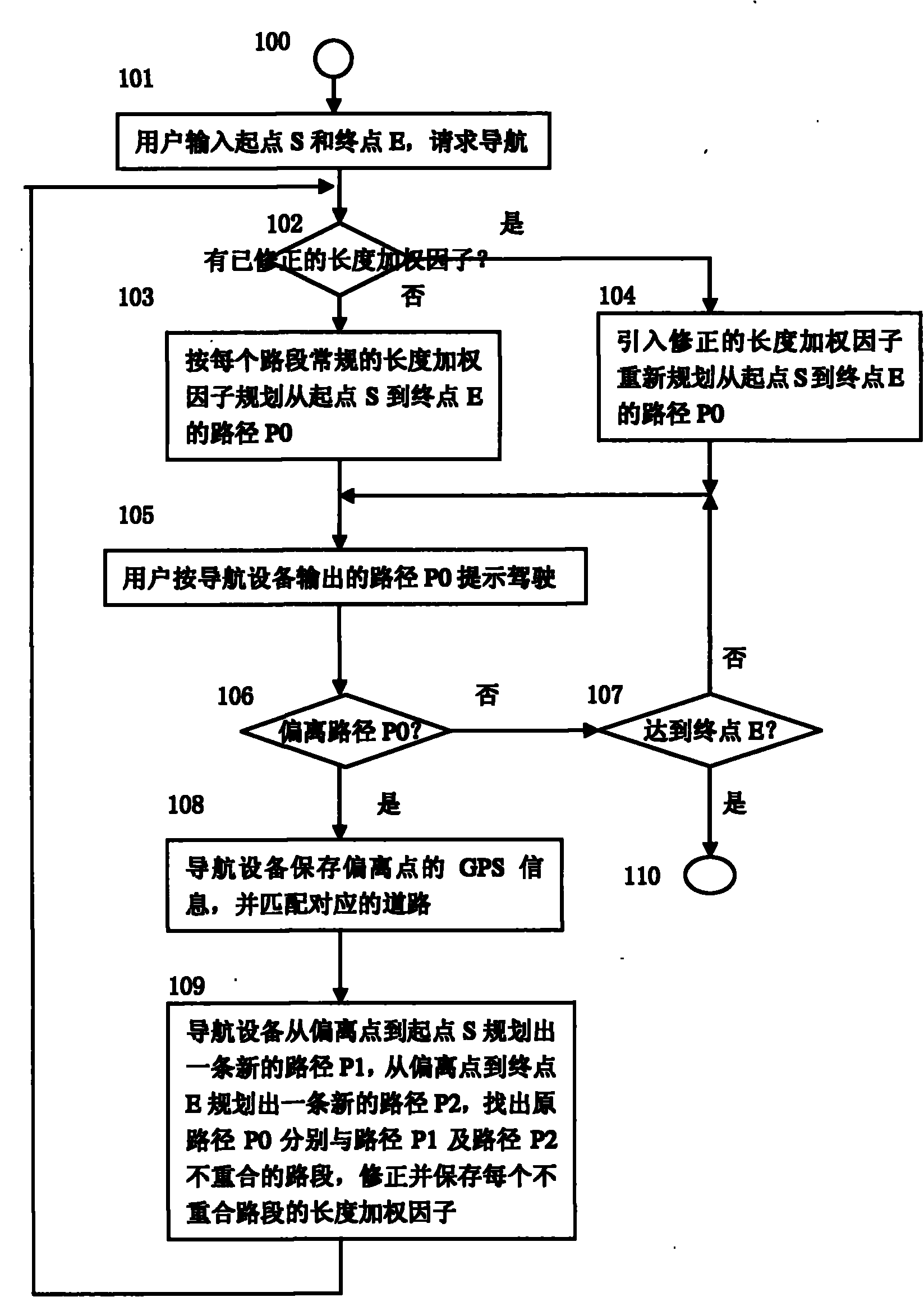
[0019] An electronic map of the navigation area is stored in a navigation device embodiment using the navigation route planning method of the present invention, and the electronic map has road information corresponding to the geographical location and the length weighting factor of the road section between each adjacent two nodes in each road .

[0020] The navigation device plans the navigation path and navigates according to the principle of the shortest distance, such as figure 1 shown. The process consists of the following steps:

[0021] Step 100, start, go to step 101.

[0022] In step 101, the user inputs a start point S and an end point E into the navigation device to request navigation; step 102 is executed.

[0023] Step 102 , the navigation device checks whether the corrected length weighting factors of each road section in the calculated route corresponding to the start point S and the end point E have been saved, and if yes, execute step 104 ; otherwise, execut...


PUM


Abstract

The invention discloses a navigation path planning method, relating to a method for path navigation equipment to plan a navigation path and navigate. The method can be used to learn the driving custom of a user. The navigation equipment is stored with an electronic map of each road section length weight coefficient and plans the navigation path according to a shortest path rule. The equipment plans a path P0 from a starting point S to an end point E according to each road section length weight coefficient; a user drives according to the path P0 prompted and output by the equipment; the equipment detects whether the user deviates from the path P0 according to real-time GPS data; and if so, the GPS information of a deviating point is stored, a path P1 is planned from the deviating point to the starting point S, a path P2 is planned from the deviating point to the end point E, the misaligned road sections of the source path P0, the path P1 and the path P2 are found, and a coefficient which is less than 1 is used for correcting the length weight coefficient of each misaligned road section, and the corrected length weight coefficient is stored; and the equipment replans the path P0 from the starting point S to the end point E and prompts the users to drive according to the new path P0.

Description

technical field [0001] The invention relates to a method for a road navigation device to plan a navigation path and perform navigation. Background technique [0002] Road route navigation is a typical application in the technical field of GPS, and it has been widely used at present. In the existing navigation path planning process, according to the principle of the shortest distance, different weighting modes can be used for the same pair of starting point and end point (such as major road priority, least toll, etc.); path result. The essence of this weighting process is to artificially change the estimated length of the road section by using different multiplicative weighting factors λ for the length of the road section between two adjacent nodes in the path. For example, for the priority weighting mode of large roads, set λ=1 for the road section on the expressway with the highest priority level; set λ>1 for main roads or other roads; Road λ=1.8; thus artificially le...

Claims


Application Information

Patent Timeline
Patent Type & Authority Applications(China)
IPC IPC(8): G01C21/34
Inventor 时宜杨一麟陈青溪曹辉标刘辉
Owner XIAMEN YAXON NETWORKS CO LTD
Why Eureka
Try Eureka